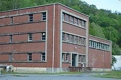
Wilcoe, West Virginia

Last updated
Wilcoe
Unincorporated community
USA West Virginia location map.svg
Red pog.svg
Wilcoe
Location within the state of West Virginia
Coordinates: 37°22′52″N81°33′50″W / 37.38111°N 81.56389°W / 37.38111; -81.56389 Coordinates: 37°22′52″N81°33′50″W / 37.38111°N 81.56389°W / 37.38111; -81.56389
Country United States
State West Virginia
County McDowell
Elevation 1,378 ft (420 m)
Time zone Eastern (EST) (UTC-5)
  Summer (DST) EDT (UTC-4)
ZIP code 24895
Area code(s) 304 & 681
GNIS feature ID 1555983 [1]

Wilcoe is a former coal town located in McDowell County, West Virginia, United States. Wilcoe was once an independent community and was incorporated into Gary in 1971. [2] Wilcoe has its own post office with ZIP code 24895. [3]

A coal town, also known as a coal camp or patch is typically situated in a remote place and provides residences for a population of miners to reside near a coal mine. A coal town is a type of company town or mining community established by the employer, a mining company, which imports workers to work the mineral find. The 'town founding' process is not limited to coal mining, nor mining, but is generally found where mineral wealth is located in a remote or undeveloped area, which is then opened for exploitation, normally first by having some transportation infrastructure brought into being first. Often, such minerals were the result of logging operations by pushing into a wilderness forest, which clear-cutting operations then allowed geologists and cartographers, to chart and plot the lands, allowing efficient discovery of natural resources and their exploitation.

McDowell County, West Virginia County in the United States

McDowell County is a county in the U.S. state of West Virginia. As of the 2010 census, the population was 22,113. Its county seat is Welch. McDowell county is the southernmost county in the state. It was created in 1858 by the Virginia General Assembly and named for Virginia Governor James McDowell. It became a part of West Virginia in 1863, when several counties seceded from the state of Virginia during the American Civil War.

West Virginia State of the United States of America

West Virginia is a state located in the Appalachian region in the Southern United States that is also considered to be a part of the Middle Atlantic States. It is bordered by Pennsylvania to the north, Maryland to the east and northeast, Virginia to the southeast, Kentucky to the southwest, and Ohio to the northwest. West Virginia is the 41st largest state by area, and is ranked 38th in population. The capital and largest city is Charleston.

Related Research Articles

A ZIP Code is a postal code used by the United States Postal Service (USPS) in a system it introduced in 1963. The term ZIP is an acronym for Zone Improvement Plan; it was chosen to suggest that the mail travels more efficiently and quickly when senders use the code in the postal address. The basic format consists of five digits. An extended ZIP+4 code was introduced in 1983 which includes the five digits of the ZIP Code, followed by a hyphen and four additional digits that reference a more specific location.

Nallen, West Virginia Unincorporated community in West Virginia, United States

Nallen is an unincorporated community in Fayette and Nicholas counties, West Virginia, United States. Nallen is located along West Virginia Route 41 12 miles (19 km) south of Summersville. Nallen has a post office with ZIP code 26680.

Spring Dale, West Virginia Unincorporated community in West Virginia, United States

Spring Dale is an unincorporated community in Fayette County, West Virginia, United States. Spring Dale is located on West Virginia Route 20 3 miles (4.8 km) northeast of Meadow Bridge. Spring Dale has a post office with ZIP code 25986.

Glen Daniel, West Virginia Unincorporated community in West Virginia, United States

Glen Daniel is an unincorporated community in Raleigh County, West Virginia, United States. Glen Daniel is located at the junction of West Virginia Route 3 and West Virginia Route 99 8.5 miles (13.7 km) west of Beckley. Glen Daniel has a post office with ZIP code 25844.

Fairdale, West Virginia Unincorporated community in West Virginia, United States

Fairdale is an unincorporated community in Raleigh County, West Virginia, United States. Fairdale is located on West Virginia Route 99 9.5 miles (15.3 km) west of Beckley. Fairdale has a post office with ZIP code 25839.

Lanark, West Virginia Unincorporated community in West Virginia, United States

Lanark is an unincorporated community in Raleigh County, West Virginia, United States. Lanark is located on West Virginia Route 41 4 miles (6.4 km) northeast of downtown Beckley. Lanark has a post office with ZIP code 25860.

Dothan, West Virginia Unincorporated community in West Virginia, United States

Dothan is an unincorporated community in Fayette County, West Virginia, United States. Dothan is located on West Virginia Route 612 4 miles (6.4 km) west of Oak Hill. Dothan had a post office, which closed on October 5, 1991.

Scarbro, West Virginia Census-designated place in West Virginia, United States

Scarbro is a census-designated place (CDP) and coal town in Fayette County, West Virginia, United States. Scarbro is 1.5 miles (2.4 km) southwest of Oak Hill. Scarbro has a post office with ZIP code 25917. As of the 2010 census, its population was 486.

Hilltop, West Virginia Census-designated place in West Virginia, United States

Hilltop is a census-designated place (CDP) in Fayette County, West Virginia, United States. Hilltop is located on West Virginia Route 16 and West Virginia Route 61 2 miles (3.2 km) south of Oak Hill. Hilltop has a post office with ZIP code 25855. As of the 2010 census, its population was 624.

Danese, West Virginia Unincorporated community in West Virginia, United States

Danese is an unincorporated community in Fayette County, West Virginia, United States. Danese is located on West Virginia Route 41 5.5 miles (8.9 km) northwest of Meadow Bridge. Danese has a post office with ZIP code 25831.

Layland, West Virginia Unincorporated community in West Virginia, United States

Layland is an unincorporated community in Fayette County, West Virginia, United States. Layland is located on West Virginia Route 41 6.5 miles (10.5 km) west-northwest of Meadow Bridge. Layland has a post office with ZIP code 25864.

Sprague, West Virginia Unincorporated community in West Virginia, United States

Sprague is an unincorporated community and coal town in Raleigh County, West Virginia, United States. Sprague is located on West Virginia Route 16 1 mile (1.6 km) north of downtown Beckley. Sprague has a post office with ZIP code 25926.

Surveyor, West Virginia Unincorporated community in West Virginia, United States

Surveyor is an unincorporated community in Raleigh County, West Virginia, United States. Surveyor is located on West Virginia Route 305 7 miles (11 km) west of Beckley. Surveyor has a post office with ZIP code 25932.

Naoma, West Virginia Unincorporated community in West Virginia, United States

Naoma is an unincorporated community in Raleigh County, West Virginia, United States. Naoma is located on West Virginia Route 3 7.5 miles (12.1 km) south-southeast of Whitesville. Naoma has a post office with ZIP code 25140.

Blount, West Virginia Unincorporated community in West Virginia, United States

Blount is an unincorporated community in Kanawha County, West Virginia, United States. Blount is 11 miles (18 km) east-southeast of Charleston. Blount had a post office, founded by Harry and Stella Blount which opened on October 30, 1946, and closed on October 24, 2009.

Dixie, Nicholas County, West Virginia Census-designated place in West Virginia, United States

Dixie is a census-designated place (CDP) in Fayette and Nicholas counties, West Virginia, United States. Dixie is located on West Virginia Route 16 5.5 miles (8.9 km) north of Gauley Bridge. Dixie has a post office with ZIP code 25059. As of the 2010 census, its population was 291, with 202 residents in Nicholas County and 89 in Fayette County.

Stollings, West Virginia Census-designated place (CDP) in West Virginia, United States

Stollings is a census-designated place (CDP) in Logan County, West Virginia, United States. Stollings is located on the Guyandotte River at the junction of West Virginia Route 10 and West Virginia Route 17, 1.5 miles (2.4 km) east-southeast of Logan. Stollings has a post office with ZIP code 25646. As of the 2010 census, its population was 316.

Saxon, West Virginia Unincorporated community in West Virginia, United States

Saxon is an unincorporated community in Raleigh County, West Virginia, United States. Saxon is 12.5 miles (20.1 km) west of Beckley. Saxon had a post office, which closed on June 27, 2009.

Mount Olive, Fayette County, West Virginia Unincorporated community in West Virginia, United States

Mount Olive is an unincorporated community in Fayette County, West Virginia, United States. Mount Olive is 5.5 miles (8.9 km) north-northwest of Gauley Bridge. The town itself has no ZIP code; however, Mount Olive Correctional Complex, West Virginia's maximum-security state prison, is located near the town and has a post office with ZIP code 25185.

Amherstdale, West Virginia Census-designated place in West Virginia, United States

Amherstdale is a census-designated place in Logan County, West Virginia, United States, along Buffalo Creek. Its population was 350 as of the 2010 census. Prior to 2010, Amherstdale was part of the Amherstdale-Robinette CDP. Amherstdale has a post office with ZIP code 25607.

References

  1. "US Board on Geographic Names". United States Geological Survey. 2007-10-25. Retrieved 2008-01-31.
  2. Garay, Ronald (2011). U.S. Steel and Gary, West Virginia: Corporate Paternalism in Appalachia. Knoxville, TN: University of Tennessee Press. p. 103. ISBN   1572337974.
  3. ZIP Code Lookup