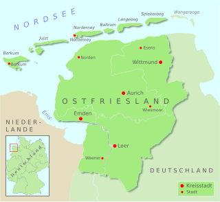
East Frisia or East Friesland is a historic region in modern Lower Saxony, Germany. The modern province is primarily located on the western half of the East Frisian peninsula, to the east of West Frisia and to the west of Landkreis Friesland but is known to have extended much further inland before modern representations of the territory. Administratively, East Frisia consists of the districts Aurich, Leer and Wittmund and the city of Emden. It has a population of approximately 469,000 people and an area of 3,142 square kilometres (1,213 sq mi).

Moordorf is an East Frisian village in Lower Saxony, Germany. It is both the highest and most densely populated Ortsteil of the municipality of Südbrookmerland, in the district of Aurich. Originally, Moordorf was a linear village but developed into a dispersed settlement due to the designation of new building areas.

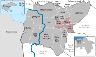
Jümme is a collective municipality (Samtgemeinde) in the district of Leer in the German state of Lower Saxony. It is named after the River Jümme which flows through all three constituent communities. It has an area of 82.34 km2 and a population of 6,421. It is situated in the region of East Frisia. Along with the Samtgemeinde of Hesel, it is one of two in the district. It was formed in the wake of local government reform in 1973. Filsum serves as the administrative centre.

Wiesmoor is a town in the district of Aurich in the northwest of Lower Saxony. It lies on the Nordgeorgsfehnkanal and is the youngest town in the East Frisia area having been bestowed town rights on 16 March 2006, two days later on 18 March 2006, Wiesmoor celebrated the Centenary of the settlement's founding. The town owes its growth to the industrialisation of the harvesting of peat from the surrounding moors. Wiesmoor holds an annual flower festival and the town is also known as the ‘Flower City’, the name originates from the large numbers of flowers which are grown in the town’s industrial greenhouse. Formerly the greenhouses were heated by waste heat from the now defunct peat burning power station which was located in the city. Wiesmoor also has the official title of a Luftkurort; tourism now plays an important role in the local economy.

Vossbarg is a row village in East Frisia, Germany. It is a Moorland colony consisting mostly of pasture land and is predominantly an agricultural area.

Wyk auf Föhr is the only town on Föhr, the second largest of the North Frisian Islands on the German coast of the North Sea. Like the entire island it belongs to the district of Nordfriesland. Wyk includes the two minor town districts of Boldixum and Südstrand.

Berumbur is a municipality in the district of Aurich, in Lower Saxony, Germany. It is part of the municipal association (Samtgemeinde) of Hage. In 2022, the municipality had approximately 2,700 inhabitants and covers an area of 6.42 square kilometers. It is located directly east of the town of Hage.

Neermoor is a village in the region of East Frisia, in Lower Saxony, Germany. Administratively, it is an Ortsteil of the municipality of Moormerland. Located to the west of the river Ems, Neermoor is approximately 8 kilometers to the north of Leer. It has a population of 4,748.

Berum is a village in the region of East Frisia, Lower Saxony, Germany. It is an Ortsteil of the municipality of Hage, part of the municipal association (Samtgemeinde) of Hage, although its metropolitan area practically borders that of the nearby town of Berumbur, to which it is located to the west.
Ostermoordorf is an East Frisian village in Lower Saxony, Germany. It is an Ortsteil of the municipality of Großheide, in the Aurich district. It is located directly to the east of Berumerfehn.

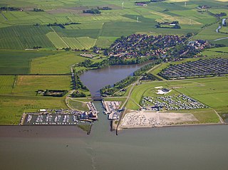
Dornumersiel is an East Frisian village and coastal resort on the Wadden Sea coast in Lower Saxony, Germany. It is an Ortsteil of the municipality of Dornum, in the Aurich district. The village is converged with the village core of Westeraccumersiel. The two settlements are only divided by Dornumersieler Tief, the historical border of Norderland and Harlingerland. Dornumersiel has been part of the municipality of Dornum since 2001.

Münkeboe is an East Frisian village in Lower Saxony, Germany. It is an Ortsteil of the municipality of Südbrookmerland, in the district of Aurich. It is located southwest of the Ewiges Meer and approximately 8 kilometers northwest of Aurich.

Marcardsmoor is a village and district (Stadtteil) of the East Frisian town of Wiesmoor, in Lower Saxony. It is located north of the town, on the intersection of the Ems-Jade Canal and the Nordgeorgsfehn Canal.
Auricher Wiesmoor II is a district (Stadtteil) of the East Frisian town of Wiesmoor, in Lower Saxony. A linear settlement, it is located southwest of the town and runs along the Voßbarg Canal.

Hinrichsfehn is a district (Stadtteil) of the East Frisian town of Wiesmoor, in Lower Saxony. It is located south of the town and west of the Nordgeorgsfehn Canal.
Mullberg is a district (Stadtteil) of the East Frisian town of Wiesmoor, in Lower Saxony. A linear settlement, it is located southeast of the town and east of the Nordgeorgsfehn Canal.
Rammsfehn is a district (Stadtteil) of the East Frisian town of Wiesmoor, in Lower Saxony. A linear settlement, it is located south of the town, along the Nordgeorgsfehn Canal, just to the northeast of Hinrichsfehn.
Wiesederfehn is a small village and district (Stadtteil) of the East Frisian town of Wiesmoor, in Lower Saxony. It is located northeast of the town, along the Bundesstraße 436.

Wilhelmsfehn I is a district (Stadtteil) of the East Frisian town of Wiesmoor, in Lower Saxony. A linear settlement, it is located northwest of the town, to the north of Wilhelmsfehn II.
Zwischenbergen is a village and district (Stadtteil) of the East Frisian town of Wiesmoor, in Lower Saxony. It is located approximately six kilometers southwest of the town center.


