This article relies largely or entirely on a single source .(June 2023) |
WILLOW 1800N 1000W | |||||||||||
---|---|---|---|---|---|---|---|---|---|---|---|
Former Chicago 'L' rapid transit station | |||||||||||
General information | |||||||||||
Location | 940-44 W. Willow St. Chicago, Illinois | ||||||||||
Coordinates | 41°54′52″N87°39′09″W / 41.9145°N 87.6525°W | ||||||||||
Owned by | Chicago Rapid Transit Company | ||||||||||
Line(s) | North Side Main Line | ||||||||||
Platforms | 2 side platforms | ||||||||||
Tracks | 4 tracks (2 express) | ||||||||||
Construction | |||||||||||
Structure type | Elevated | ||||||||||
History | |||||||||||
Opened | 1905 | ||||||||||
Closed | May 17, 1942 | ||||||||||
Former services | |||||||||||
| |||||||||||
|
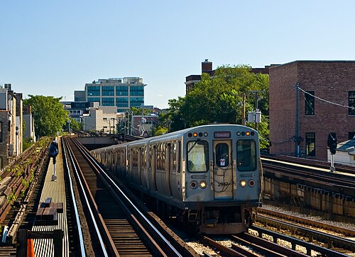
Willow was a station on the Chicago Rapid Transit Company's North Side Main Line, which is now part of the Chicago Transit Authority's Brown Line. The station was located at 940-44 W. Willow Street in the Lincoln Park neighborhood of Chicago. Willow was situated south of Armitage and north of Halsted, which is now closed. Willow opened in 1905 and closed on May 17, 1942, to allow for the construction of a new portal to the State Street subway. [1]
The Red Line is a rapid transit line in Chicago, run by the Chicago Transit Authority (CTA) as part of the Chicago "L" system. It is the busiest line on the "L" system, with an average of 108,303 passengers boarding each weekday in 2023 The route is 26 miles (42 km) long with a total of 33 stations. It runs elevated from the Howard station in the Rogers Park neighborhood on the North Side, through the State Street subway on the Near North Side, Downtown, and the South Loop, and then through the Dan Ryan Expressway median to 95th/Dan Ryan in the Roseland neighborhood on the South Side.
The Green Line is a rapid transit line in Chicago, Illinois, operated by the Chicago Transit Authority (CTA) as part of the Chicago "L" system. It is the only completely elevated route in the "L" system. All other routes may have various combinations of elevated, subway, street level, or freeway median sections. This line is also the only route with three terminals: trains departing Harlem/Lake alternate destinations between Ashland/63rd and Cottage Grove.
Cicero is a station on the Chicago Transit Authority's 'L' system, serving the Green Line. It opened on March 3, 1894, and serves the Austin neighborhood on Chicago's West side. Until 1948, the next station towards the Chicago Loop was Kostner. The station is 24 blocks east and 2 blocks north of Harlem.
Central is a station on the Chicago Transit Authority's 'L' system and is located at 350 North Central Avenue in the Austin neighborhood on Chicago's West side.
Halsted station is an "L" station on the CTA Orange Line, located near the intersection of Halsted Street and Archer Avenue in the Bridgeport neighborhood of Chicago. The station opened in 1993 as part of the extension to Midway Airport. A previous railroad station just to the east opened in 1902 and served the Metra Heritage Corridor until 1984.
The Chicago and Joliet Electric Railway, or C&JE, was an electric interurban railway linking the cities of Chicago and Joliet, Illinois. It was the only interurban between those cities and provided a link between the streetcar network of Chicago and the cities along the Des Plaines River Valley in north central Illinois, which were served by the Illinois Valley Division of the Illinois Traction System.
Grace was a station on the Chicago Transit Authority's Howard Line, which is now part of the Red Line. The station was located at Grace Street and Sheffield Avenue in the Lakeview neighborhood of Chicago. Grace was situated north of Addison and south of Sheridan. Grace opened on June 7, 1900, and closed on August 1, 1949, along with 22 other stations as part of a CTA service revision.
Clark was a station on the Chicago Transit Authority's Howard Line, which is now part of the Red Line. The station was located at the corner of Clark and Roscoe Streets in the Lakeview neighborhood of Chicago, at what is now the junction between the Red and Brown lines. Clark was situated north of Belmont and south of Addison. Clark opened on June 6, 1900, and closed on August 1, 1949, along with 22 other stations as part of a CTA service revision.
Halsted was a station on the Chicago Transit Authority's North Side Main Line, which is now part of the Brown Line. The station was located at 1618 N. Halsted Street in the Lincoln Park neighborhood of Chicago. Halsted was situated south of Armitage and north of Larrabee, which closed at the same time as Halsted. It was one of only four "L" stations that were built on s-curves; Sheridan, Indiana, and Sacramento were the other three. Halsted opened on May 31, 1900, and closed on August 1, 1949, along with 22 other stations as part of a CTA service revision.
Larrabee, also known as Larrabee & Ogden, was a station on the Chicago Transit Authority's North Side Main Line, which is now part of the Brown Line. The station was located at 1540 N. Larrabee Street in the Near North Side neighborhood of Chicago. Larrabee was situated east of Halsted, which closed at the same time as Larrabee, and north of Sedgwick.
Schiller was a station on the Chicago Transit Authority's North Side Main Line, which is now part of the Brown Line. The station was located at 315 W. Schiller Street in the Near North Side neighborhood of Chicago. Schiller was situated south of Sedgwick and north of Division, which closed at the same time as Schiller. Schiller opened on May 31, 1900, and closed on August 1, 1949, along with 22 other stations as part of a CTA service revision.
Division was a station on the Chicago Transit Authority's North Side Main Line, which is now part of the Brown Line. The station was located at 322 W. Division Street in the Near North Side neighborhood of Chicago. Division was situated south of Schiller and north of Oak, both of which closed at the same time as Division. Division opened on May 31, 1900, and closed on August 1, 1949, along with 22 other stations as part of a CTA service revision.
Oak was a station on the Chicago Transit Authority's North Side Main Line, which is now part of the Brown Line. The station was located at 319 W. Oak Street in the Near North Side neighborhood of Chicago. Oak was situated south of Division, which closed at the same time as Oak, and north of Chicago. Oak opened in 1906 and closed on August 1, 1949, along with 22 other stations as part of a CTA service revision.
26th was a station on the Chicago Transit Authority's South Side Main Line, which is now part of the Green Line. The station was located at 26th Street and Wabash Avenue in the Near South Side neighborhood of Chicago. 26th was situated south of Cermak and north of 29th. 26th opened on June 6, 1892, and closed on August 1, 1949.
31st was a station on the Chicago Transit Authority's South Side Main Line, which is now part of the Green Line. The station was located at 31st Street near State Street in the Douglas neighborhood of Chicago. 31st was situated south of 29th and north of 33rd. 31st opened on June 6, 1892, and closed on August 1, 1949.
33rd was a station on the Chicago Transit Authority's South Side Main Line, which is now part of the Green Line. The station was located at 33rd Street and Wabash Avenue in the Douglas neighborhood of Chicago. 33rd was situated south of 31st and north of Tech–35th, which is now named 35th–Bronzeville–IIT. 33rd opened on June 6, 1892, and closed on August 1, 1949. Portions of the station remained in service as part of Tech–35th until September 25, 1961.
Pershing was a station on the Chicago Transit Authority's South Side Elevated Line, which is now part of the Green Line. The station was located at Pershing Road and State Street in the Douglas neighborhood of Chicago. Pershing was situated south of Tech–35th, which is now named 35th–Bronzeville–IIT, and north of Indiana. Pershing opened on June 6, 1892, and closed on August 1, 1949.
The Cermak branch, formerly known as the Douglas branch, is a 6.6 mi (10.6 km) long section of the Pink Line of the Chicago "L" system in Chicago, Illinois. It was built by the Metropolitan West Side Elevated west of the Loop. As of February 2013, it serves an average of 17,474 passengers every weekday. The branch serves the Near West Side, Pilsen, Lower West Side, South Lawndale, and North Lawndale neighborhoods of Chicago, and the west suburb Cicero, Illinois. The branch operates from 4:05 a.m. to 1:25 a.m., weekdays, and Saturdays from 5:05 a.m. to 1:25 a.m., and Sundays from 5:00 a.m. to 1:25 a.m., including holidays.
The Garfield Park Branch was a rapid transit line which was part of the Chicago "L" system from 1895 to 1958. The branch served Chicago's Near West Side, East Garfield Park, West Garfield Park, and Austin neighborhoods, and the suburbs of Oak Park, and Forest Park, and consisted of twenty-two stations. It opened on June 19, 1895 and closed on June 22, 1958, when it was replaced by the Congress branch of the Blue Line.