Argyle station (CTA)

Last updated

Argyle
 
5000N
1200W
Chicago 'L' rapid transit station
Northbound track at Argyle, looking south on Phase 1B opening night.jpg
Temporary platform in use until 2025
General information
LocationTemporarily between Broadway, Winthrop Avenue, Foster Avenue, and Winona Street (originally 1118 West Argyle Street)
Chicago, Illinois 60640
Coordinates 41°58′24″N87°39′31″W / 41.973365°N 87.658561°W / 41.973365; -87.658561
Owned by Chicago Transit Authority
Line(s) North Side Main Line
Platforms1 Island platform
Tracks4 (two temporarily out of service)
Construction
Structure type Elevated
ParkingNo
Bicycle facilitiesNo
AccessibleStarting 2025
Other information
StatusTemporary station
History
OpenedChicago & Evanston Railroad:
May 21, 1885;138 years ago (1885-05-21)
Northwestern Elevated Railroad:
May 16, 1908;115 years ago (1908-05-16)
Rebuilt1921, 2012, 202125
Previous namesArgyle Park
Passengers
2022717,349 [1] Increase2.svg 39%
Services
Preceding station Chicago "L" Following station
Bryn Mawr
One-way operation
Red Line Wilson
Berwyn
Temporarily closed
toward Howard
Lawrence
Temporarily closed
      Purple Line does not stop here
Former services
Preceding station Milwaukee Road Following station
Edgewater Chicago  Evanston Sheridan Park
towards Chicago
Location
Argyle station (CTA)

Argyle is a station on the Chicago Transit Authority's 'L' system. It is situated between the Berwyn and Lawrence stations on the Red Line, which runs from Rogers Park at Chicago's northern city limits, through downtown Chicago, to Roseland. It is an elevated station with an island platform. Located at 1118 West Argyle Street in the West Argyle Street Historic District of Chicago's Uptown community area. Purple Line weekday rush hour express service passes through this station but does not stop, normally on tracks outside the Red line tracks, but due to the reconstruction going on until 2025, they currently use the same tracks as Red Line trains.

Contents

Location

Argyle is situated on West Argyle Street, close to the intersection with Broadway though it has temporarily been located slightly north to a location between Foster Avenue and Winona Street due to reconstruction at the original site. The station is located in the West Argyle Street Historic District in the Uptown community area of Chicago; the area surrounding the station consists of a mixture commercial and residential areas, [2] and is particularly noted for the high concentration of Vietnamese restaurants, bakeries and shops; as well as Chinese, Cambodian, Laotian, and Thai businesses. [3]

History

The new embankment at Argyle station in 1916 Argyle Station 19160116.jpg
The new embankment at Argyle station in 1916

The site of Argyle station was first used as Argyle Park on the Chicago and Evanston branch of the Chicago, Milwaukee & St. Paul Railroad route, which opened on May 21, 1885. [4] On opening, the station houses along the route were described as "attractive frame structures built in the Gothic and Queen Anne styles." [4] 
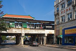
In 1908, the Northwestern Elevated Railroad was extended north from Wilson, using the tracks of the Chicago, Milwaukee & St. Paul Railroad, and a new station was constructed on the site of the previous depot. [5] [6] The station was again rebuilt to a design by architect Charles P. Rawson when the tracks between Wilson and Howard were elevated onto an embankment between 1914 and 1922. [7] In 1979, the station received a $250,000 facelift [8] and, in 1991, a Chinese-style hipped-and-gabled roof was added to the platform canopy. [9] The station was closed for renovation from August 24 to October 5, 2012. [10]

Services

A northbound train at Argyle station, July 2010 Argyle CTA 20100729.jpg
A northbound train at Argyle station, July 2010

Argyle is part of CTA's Red Line, which runs from the northern city limits at Howard Street to downtown Chicago and 95th street. The station has an island platform on an elevated structure located between Broadway and Winthrop Avenue. It serves the Red Line's two tracks; the northbound track serves trains to Howard, while the southbound track serves trains to 95th. The station entrance was originally located on the north side of Argyle Street, built into the embankment. It is located between the Berwyn and Lawrence stations. Red Line trains serve Argyle 24 hours a day, every day of the year; trains operate roughly every 3 to 9 minutes during rush hour and midday operation, with longer headways of up to 15 minutes at night. [11] [12] The station is also located 12 a block from the 36 Broadway bus.

Red & Purple Modernization Project

The Argyle station is being rebuilt as part of this project. The station will receive new wider platforms, new signage, new lights, new security cameras, and new elevators, reconstruction will begin in May 2021 and will be completed in 2025. [13] [14] [15] During Stage A, the two northbound tracks and the main entrance were closed with northbound trains using what is normally the southbound Red line track and platform and southbound trains using the southbound Purple Line Express track stopping at a temporary side platform. Purple Line Express trains will continue to skip this station in both directions. [15] Unlike a similar reconstruction that happened simultaneously at Bryn Mawr, both platforms are used single temporary entrance, as opposed to one platform using the normal entrance and one platform using a temporary entrance with no link in the paid area. After Stage A was completed in 2023, Stage B began, where the station was temporarily relocated a block north to a location between Foster Avenue and Winona Street with an entrance on each street. [16] This time, the temporary station is an island platform located on what will be the permanent northbound Red Line track, located between what will be a completely new pocket track (which did not exist on the original structure) immediately to the north of the site of both the original and permanent new stations (currently being used by all southbound trains), and the permanent Purple Line Express northbound track (currently being used by all northbound trains).

Related Research Articles

<span class="mw-page-title-main">Chicago "L"</span> Rapid transit system in Chicago, Illinois, US

The Chicago "L" is the rapid transit system serving the city of Chicago and some of its surrounding suburbs in the U.S. state of Illinois. Operated by the Chicago Transit Authority (CTA), it is the fourth-largest rapid transit system in the United States in terms of total route length, at 102.8 miles (165.4 km) long as of 2014, and the third-busiest rapid transit system in the United States. In 2016, the "L" had 1,492 rail cars, eight different routes, and 145 train stations. In 2023, the system had 117,447,000 rides, or about 373,800 per weekday in the fourth quarter of 2023.

<span class="mw-page-title-main">Red Line (CTA)</span> Rapid transit line in Chicago

The Red Line is a rapid transit line in Chicago, run by the Chicago Transit Authority (CTA) as part of the Chicago "L" system. It is the busiest line on the "L" system, with an average of 93,457 passengers boarding each weekday in 2022. The route is 26 miles (42 km) long with a total of 33 stations. It runs elevated from the Howard station in the Rogers Park neighborhood on the North Side, through a subway on the Near North Side, Downtown, and the South Loop, and then through the Dan Ryan Expressway median to 95th/Dan Ryan in the Roseland neighborhood on the South Side.

<span class="mw-page-title-main">Purple Line (CTA)</span> Rapid transit line run by the Chicago Transit Authority

The Purple Line of the Chicago "L" is a 3.9-mile (6.3 km) route on the northernmost section of the system. The service normally begins from Linden in Wilmette and ends at Howard on Chicago's north border, passing through the city of Evanston.

<span class="mw-page-title-main">Howard station (CTA)</span> Chicago "L" station

Howard is an 'L' station in Chicago, Illinois on the North Side Main Line. It is the northern terminus of the Red Line and the southeastern terminus of the Yellow Line; it also serves the Purple Line, for which it is the southern terminus at non-rush hour times on weekdays and all day on weekends. Trains on the Chicago North Shore and Milwaukee Railroad also stopped at Howard from 1926 until that line was abandoned in 1963.

<span class="mw-page-title-main">Berwyn station (CTA)</span> Chicago "L" station

Berwyn is a temporarily closed 'L' station on the CTA's Red Line. It is located at 1121 West Berwyn Avenue in the Edgewater neighborhood of Chicago, Illinois. The adjacent stations are Bryn Mawr, located about 38 mile (0.60 km) to the north, and Argyle, about 13 mile (0.54 km) to the south, both still in service and serving as alternate stations. Four tracks pass through the station, but there is only single island platform in the center of the tracks. The two western tracks are temporarily out of service for construction and trains on both the Red and Purple Lines pass Berwyn on the eastern tracks without stopping. When it reopens, it will consist of an island platform with Red Line trains stopping on the inner tracks and Purple Line Express trains bypassing the station on the outer tracks. Berwyn is named for the Berwyn station in the community of the same name, which is west of Philadelphia. Many of the roads in the Edgewater neighborhood are named after stations on the former Pennsylvania Railroad Main Line.

<span class="mw-page-title-main">Loyola station</span> Chicago "L" station

Loyola is a station on the Chicago Transit Authority's 'L' system, served by the Red Line. It is located at 1200 West Loyola Avenue in the Rogers Park neighborhood of Chicago, Illinois. The station has high ridership by students from the nearby Lakeshore Campus of Loyola University Chicago. The Red Line right-of-way runs directly through the southwest corner of the campus. Purple Line weekday rush hour express service use the outside tracks but do not stop at this station.

<span class="mw-page-title-main">Belmont station (CTA North Side Main Line)</span> Chicago "L" station

Belmont is an 'L' station serving the CTA's North Side Main Line. It is served at all times by the Red and Brown Lines, and by the Purple Line Express during weekday rush hours. It is located at 945 West Belmont Avenue in the Lakeview neighborhood of Chicago, Illinois. It is an elevated station with two island platforms serving four tracks; Brown and Purple Line trains share the outer tracks while Red Line trains run on the inner tracks. Along with residential areas, the neighborhood surrounding Belmont contains many eclectic shops, bars, and restaurants and active nightlife. The station is one of the more heavily utilized on the system serving as a busy transfer point, and also as a terminal when the Brown Line operates as a shuttle service to and from Kimball late at night and early in the morning. It is nearly identical to Fullerton, minus the terminal status.

<span class="mw-page-title-main">Merchandise Mart station</span> Chicago "L" station

Merchandise Mart is a station on the Chicago Transit Authority's 'L' system, located in the Near North Side neighborhood at 350 North Wells Street in Chicago, Illinois. The station is elevated above street level, on a steel structure. The turnstiles and customer assistant booth of the station are located on the second level of the Merchandise Mart itself. This is the main entrance to the station.

<span class="mw-page-title-main">Noyes station</span> Chicago "L" station

Noyes is a station on the Chicago Transit Authority's 'L' system, on the Purple Line in Evanston, Illinois. It is located at 909 Noyes Street, just a few blocks west of the north end of Northwestern University's Evanston campus. The Noyes Cultural Center is also nearby. This area of Evanston is a mix of residential and light commercial properties.

<span class="mw-page-title-main">Central station (CTA Purple Line)</span> Chicago "L" station

Central is a Purple Line station of the Chicago Transit Authority 'L' system. Located at 1024 Central Street in Evanston, Illinois, the elevated platform sits above Central Street, half a block west of Ridge Avenue. The station itself, a Beaux-Arts structure designed by noted transit architect Arthur Gerber, is on the south side of Central Street and is entered at street level, with an auxiliary exit on the north side of the street.

<span class="mw-page-title-main">Foster station</span> Chicago "L" station

Foster is a station on the Chicago Transit Authority's 'L' system, on the Purple Line in Evanston, Illinois. It is located at 900 Foster Street, just a few blocks west of Northwestern University's Evanston campus.

<span class="mw-page-title-main">Addison station (CTA Red Line)</span> Chicago "L" station

Addison is a Chicago "L" station on the Chicago Transit Authority Red Line. It is located in the Wrigleyville area of the Lakeview neighborhood of Chicago, Illinois, at 940 West Addison Street with city block coordinates at 3600 North at 940 West. Addison directly serves Wrigley Field, home of Major League Baseball's Chicago Cubs. The station is within the shadow of the historic baseball stadium, which was built with convenient access to the "L".

<span class="mw-page-title-main">Sheridan station (CTA)</span> Chicago "L" station

Sheridan is an 'L' station on the CTA's Red Line. It is an elevated station with two island platforms, located at 3940 North Sheridan Road, in the Lakeview neighborhood of Chicago's Lakeview community area. Sheridan is the closest 'L' stop to Graceland Cemetery, which is about one-half mile to the west on Irving Park Road. The Sheridan station is one of only two remaining 'L' stations that were built on S-curves; Indiana on the Green Line is the other. Purple Line weekday rush hour express service use the outside tracks but only a certain number of them stop at this station when the Chicago Cubs have weekday evening home games scheduled.

<span class="mw-page-title-main">Wilson station (CTA)</span> Chicago "L" station

Wilson is an 'L' station on the CTA's North Side Main Line, located at 4620 North Broadway in the Uptown neighborhood of Chicago, Illinois. It is served at all times by the Red Line and by the Purple Line on weekdays at rush hour.

<span class="mw-page-title-main">Fullerton station (CTA)</span> Chicago "L" station

Fullerton is an 'L' station on the CTA's North Side Main Line. It is served at all times by Red and Brown Line trains; Purple Line Express trains also stop at the station during weekday rush hours. It is an elevated station with two island platforms, serving four tracks, located in the Lincoln Park neighborhood in Chicago, Illinois. Brown and Purple Line trains share the outer tracks while Red Line trains run on the inner tracks. As well as being an important transfer station, the station serves the Lincoln Park Campus of DePaul University.

<span class="mw-page-title-main">Evanston Davis Street station</span> Commuter rail station in Evanston, Illinois

Evanston Davis Street is a commuter railroad station in downtown Evanston, Illinois. It is served by Metra's Union Pacific North Line with trains going south to Ogilvie Transportation Center in Chicago and as far north as Kenosha, Wisconsin. In Metra's zone-based fare system, Davis Street is in zone 2. As of 2018, Evanston Davis Street is the 12th busiest of Metra's 236 non-downtown stations, with an average of 1,876 weekday boardings. The station is next to the Davis station of the Chicago Transit Authority's Purple Line, where CTA and Pace buses terminate. Between the two stations is 909 Davis Street, a six-story building with a kiss-and-ride loop for car drop-off.

<span class="mw-page-title-main">Bryn Mawr station (CTA)</span> Rapid transit station in Chicago

Bryn Mawr is an 'L' station on the CTA's Red Line. It is located at 1119 West Bryn Mawr Avenue in the Bryn Mawr Historic District of the Edgewater neighborhood of Chicago, Illinois. The adjacent stations are Thorndale, located about one half mile to the north, and Berwyn, about three eighths of a mile to the south. Four tracks pass through the station, but the two western tracks are currently out of service for reconstruction. There is an island platform in the center of the tracks which currently only serves southbound trains; Purple Line weekday rush hour express service pass through the station on the same tracks used by the Red Line but do not stop. The name "Bryn Mawr" comes from the SEPTA Regional Rail station located northwest of Philadelphia in the community of the same name. The name came to the area in the 1880s by Edgewater developer John Lewis Cochran, and is Welsh for "Big Hill."

<span class="mw-page-title-main">Lawrence station (CTA)</span> Chicago "L" station

Lawrence is a temporarily closed 'L' station on the Chicago Transit Authority's Red Line. It is an elevated station located at 1117 West Lawrence Avenue in the Uptown neighborhood of Chicago, Illinois. The adjacent stations are Argyle, located about 13 mile (0.54 km) to the north, and Wilson, about 14 mile (0.40 km) to the south, serving as alternate stations remaining open while Lawrence is closed for reconstruction. Four tracks pass through the station, though the two western tracks are out of service for reconstruction with all trains passing through without stopping on the two eastern tracks. Prior to demolition in 2021, there was a single island platform in the center of the tracks; Purple Line weekday rush hour express service used the outside tracks and did not stop.

<span class="mw-page-title-main">Diversey station</span> Chicago "L" station

Diversey is an 'L' station on the CTA Brown Line; Purple Line express trains also stop at the station during weekday rush hours. It is an elevated station with two side platforms, located in the Lincoln Park neighborhood of Chicago, Illinois. Red Line trains pass through the station on the middle tracks, but do not stop.

<span class="mw-page-title-main">North Side main line</span>

The North Side Main Line is a branch of the Chicago "L" system that is used by Red, Purple, and Brown Line trains. As of 2012, it is the network's busiest rail branch, serving an average of 123,229 passengers each weekday. The branch is 10.3 miles (16.6 km) long with a total of 21 stations, from Howard Street in Rogers Park down to Lake Street in Chicago's Loop. The branch serves the north side of the city 24 hours a day, seven days a week.

References

  1. "Annual Ridership Report Calendar Year 2022" (PDF). Chicago Transit Authority, Ridership Analysis and Reporting. February 2, 2023. Retrieved June 9, 2023.
  2. City of Chicago Zoning Map (Map). Chicago Department of Zoning. 2010.
  3. "Uptown's Argyle Street Named To Historic Register". CBS2 Chicago: Chicago Area Local News. CBS Broadcasting Inc. June 14, 2010. Archived from the original on June 21, 2010. Retrieved July 29, 2010.
  4. 1 2 "The Chicago & Evanston". Chicago Daily Tribune. May 22, 1885.
  5. "Electrification of the Evanston Suburban Line of the Chicago Milwaukee & St. Paul". The Railway Age. 44 (14): 467. October 4, 1907. Retrieved July 29, 2010.
  6. Garfield, Graham. "Argyle". Chicago-"L".org. Graham Garfield. Retrieved July 29, 2010.
  7. Borzo, Greg (2007). The Chicago "L". Chicago: Arcadia Publishing. p. 70. ISBN   978-0-7385-5100-5.
  8. Lynch, Kevin; Janega, James (April 4, 2001). "Charlie Soo 1945-2001. - Argyle Street 'Mayor,' Bold Promoter of Asian Shops". Chicago Tribune.
  9. McCarron, John (February 6, 1991). "'Mayor' Brings New Life to Argyle Street". Chicago Tribune.
  10. "Red Ahead: Argyle". Chicago Transit Authority. Retrieved December 3, 2012.
  11. "Red Line Route Guide". Chicago Transit Authority. Archived from the original on July 22, 2010. Retrieved July 29, 2010.
  12. "Argyle Station Timetable" (PDF). Chicago Transit Authority. Archived from the original (PDF) on July 30, 2010. Retrieved July 29, 2010.
  13. "CTA unveils new Red Line station designs". January 28, 2021.
  14. "Four CTA Red Line stations are getting a makeover".
  15. 1 2 "CTA Red & Purple Modernization: Lawrence to Bryn Mawr Modernization Project".
  16. https://www.transitchicago.com/rpm/