
Prince Frederick is an unincorporated community and census-designated place (CDP) in Calvert County, Maryland, United States. As of the 2010 census, the population of Prince Frederick was 2,538, up from 1,432 at the 2000 census. It is the county seat of Calvert County.

Baron Baltimore or Lord Baltimore, of Baltimore Manor in County Longford, was a title in the Peerage of Ireland. It was created in 1625 and ended in 1771, upon the death of its sixth-generation male heir, aged 40.

The Province of Maryland was an English and later British colony in North America that existed from 1632 until 1776, when it joined the other twelve of the Thirteen Colonies in rebellion against Great Britain and became the U.S. state of Maryland. Its first settlement and capital was St. Mary's City, in the southern end of St. Mary's County, which is a peninsula in the Chesapeake Bay and is also bordered by four tidal rivers.
Wilson, Maryland may refer to the following places in Maryland:

Elihu Emory Jackson, a member of the United States Democratic Party, was the 41st Governor of Maryland in the United States from 1888 to 1892. He was born in 1837 in Delmar, Maryland and died in 1907 in the City of Baltimore, Maryland. He is buried at the Parsons Cemetery in Salisbury, Maryland, the county seat of Wicomico County. He was part owner of Pemberton Hall, listed on the National Register of Historic Places in 1971.

Southern Maryland in popular usage is composed of the state's southernmost counties on the "Western Shore" of the Chesapeake Bay in the state of Maryland. This region includes all of Calvert, Charles, and St. Mary's counties and sometimes the southern portions of Anne Arundel and Prince George's counties.
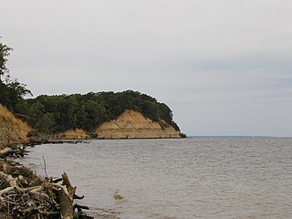
Calvert Cliffs State Park is a public recreation area in Lusby, Calvert County, Maryland, that protects a portion of cliffs that extend for 24 miles along the eastern flank of the Calvert Peninsula on the west side of Chesapeake Bay from Chesapeake Beach southward to Drum Point. The state park is known for the abundance of mainly Middle Miocene sub-epoch fossils that can be found on the shoreline.

Charles Benedict Calvert was an American politician who was a U.S. Representative from the sixth district of Maryland, serving one term from 1861 to 1863. He was an early backer of the inventors of the telegraph, and in 1856 he founded the Maryland Agricultural College, the first agricultural research college in America, now known as the University of Maryland. He was a direct descendant of the Lords Baltimore, proprietary governors of the Province of Maryland from 1631 until 1776.

Calvert is an unincorporated community in Cecil County, Maryland, United States, about 6 miles east of Rising Sun.

Maryland's 5th congressional district comprises all of Charles, St. Mary's, and Calvert counties, as well as portions of Prince George's and Anne Arundel counties. The district is currently represented by Democrat Steny Hoyer, the current House Majority Leader.

The Cove Point Light is a lighthouse located on the west side of Chesapeake Bay in Calvert County, Maryland.

Benedict is a small unincorporated town and census-designated place in Charles County, Maryland, United States located on the Patuxent River in southern Maryland. As of the 2010 census, it had a population of 261.

The Chesapeake Beach railway station is a historic railway station located at Chesapeake Beach, Calvert County, Maryland, United States. It is composed of two one-story, hip-roofed sections; one part was once an open passenger boarding area that was later enclosed for storage. The station was erected in 1898, for the Chesapeake Beach Railway. It is now operated as a railway museum.

This is a list of the National Register of Historic Places listings in Calvert County, Maryland.
Fairhaven is an unincorporated community in Anne Arundel County, Maryland, United States. Maryland Route 423 connects Fairhaven with Maryland Route 2, which goes north to Annapolis, the state capital, and south to Prince Frederick, the county seat of Calvert County.
Zekiah Swamp is part of the Potomac River basin in Charles County, Maryland in the United States. The swamp is 21 miles (34 km) of braided stream stretching the length of Charles County and is a tributary of the Potomac River. It sits at an elevation of three feet (0.91 m) and 450 acres (180 ha) of its southern end is protected as the Zekiah Swamp Natural Environment Area. The Maryland Department of Natural Resources has the authority to purchase an additional 5,000 acres (2,000 ha) for the park. Charles County has moved to protect an additional 65,000 acres (26,000 ha) of the wetland. The headwaters of the swamp are protected as part of Cedarville State Forest. It was first accurately surveyed by John Henry Alexander, Maryland's official cartographer, in 1835, as "Allen's Fresh".
Wilson is an unincorporated community in Calvert County, Maryland, United States. Wilson is located along Wilson Road near the Chesapeake Bay, 5.5 miles (8.9 km) northeast of Prince Frederick.
Calvert Beach is a census-designated place and unincorporated community in Calvert County, Maryland, United States. Its population was 808 as of the 2010 census. Prior to 2010, the community was part of the Calvert Beach-Long Beach CDP.

The United States presidential election in Maryland, 1976 was held on November 2, 1976. Incumbent Republican President Gerald Ford of Michigan and his running mate Senator Bob Dole of Kansas lost to the Democratic challengers, Governor Jimmy Carter of Georgia and Senator Walter Mondale of Minnesota. Carter and Mondale won the state with 53.04 percent of the vote compared to Ford and Dole’s 46.96 percent – a comfortable margin of 6.08 percent.


