The Continental Divide is the principal, and largely mountainous, hydrological divide of the Americas. The Continental Divide extends from the Bering Strait to the Strait of Magellan, and separates the watersheds that drain into the Pacific Ocean from those river systems that drain into the Atlantic Ocean and, along the northernmost reaches of the Divide, those river systems that drain into the Arctic Ocean.

Mount Cleveland is the highest mountain in Glacier National Park, located in Montana, United States. It is also the highest point in the Lewis Range, which spans part of the northern portion of the Park and extends into Canada. It is located approximately 3 mi (4.8 km) southeast of the southern end of Waterton Lake, and approximately 5 mi (8.0 km) south of the US/Canada border. The east side of the future national park was purchased by the federal government from the Blackfoot Confederacy in 1895 during the second term of President Cleveland. According to the United States Board on Geographic Names, the mountain is named for the former president.

Heavens Peak is located in the Livingston Range, Glacier National Park in the U.S. state of Montana. Heavens Peak is a little more than 1 mile (1.6 km) north of McPartland Mountain.
The Lewis Range is a mountain range located in the Rocky Mountains of northern Montana, United States and extreme southern Alberta, Canada. It was formed as a result of the Lewis Overthrust, a geologic thrust fault resulted in the overlying of younger Cretaceous rocks by older Proterozoic rocks. The range is located within Waterton Lakes National Park in Alberta, Canada and Glacier National Park and the Bob Marshall Wilderness Complex in Montana, United States. The highest peak is Mount Cleveland at 10,466 ft (3,190 m).
Marias Pass is a high mountain pass near Glacier National Park in northwestern Montana in the United States.

Babb is a small unincorporated farming and ranching community in Glacier County, Montana, United States, on the Blackfeet Indian Reservation. The community experiences a large influx of tourist in the summer months as it is the gateway to the Many Glacier area of Glacier National Park. Babb is a census-designated place (CDP) and had a population of 174 at the 2010 census.

Mount Jackson is located in the Lewis Range, Glacier National Park in the U.S. state of Montana. Mount Jackson is the fourth tallest mountain in Glacier National Park and it is situated on the Continental Divide. Both the mountain and its namesake Jackson Glacier are easily seen from the Going-to-the-Sun Road. Harrison Glacier, the park's largest remaining glacier, is located on the mountain's southern flank.

Blackfoot Mountain is located in the Lewis Range, Glacier National Park in the U.S. state of Montana. To the north of Blackfoot Mountain lies Blackfoot Glacier, one of the largest glaciers in the park. The stagnant Pumpelly Glacier is located to the immediate east and northeast of the mountain.

Curly Bear Mountain is located in the Lewis Range, Glacier National Park in the U.S. state of Montana. Curly Bear Mountain is easily seen from the village of Saint Mary, Montana rising just west of Divide Mountain. The peak was named after Blackfoot warrior and historian Curly Bear (Kyáiyo-xusi).

Divide Mountain is located in the Lewis Range, Glacier National Park in the U.S. state of Montana. Divide Mountain is located south of Saint Mary, Montana on the border of Glacier National Park and the Blackfeet Indian Reservation.
Gable Mountain is located in the Lewis Range, Glacier National Park in the U.S. state of Montana. Gable Mountain is in the northeastern section of Glacier National Park, approximately 3 miles (4.8 km) southwest of the prominent Chief Mountain.

Grizzly Mountain is located in the Lewis Range, Glacier National Park in the U.S. state of Montana. Grizzly Mountain sits astride the Continental Divide in the Two Medicine region of Glacier National Park.
Kaina Mountain is located in the Lewis Range, Glacier National Park in the U.S. state of Montana. Kaina Mountain is in the northeastern section of Glacier National Park and north of Kaina Lake.
Seward Mountain is located in the Lewis Range, Glacier National Park in the U.S. state of Montana.
White Calf Mountain is located in the Lewis Range, Glacier National Park in the U.S. state of Montana. White Calf Mountain is south of Divide Mountain and just west of the Blackfeet Indian Reservation boundary.

Mount Oberlin is located in the Lewis Range, Glacier National Park in the U.S. state of Montana. Mount Oberlin is just northwest of Logan Pass. Below the summit to the northwest, water and melting snow off Mount Oberlin lead to the 492 feet (150 m) Bird Woman Falls, one of the tallest waterfalls in Glacier National Park.

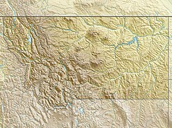
The Regional designations of Montana vary widely within the U.S state of Montana. The state is a large geographical area that is split by the Continental Divide, resulting in watersheds draining into the Pacific Ocean, Gulf of Mexico and Hudson's Bay. The state is approximately 545 miles (877 km) east to west along the Canada–United States border and 320 miles (510 km) north to south. The fourth largest state in land area, it has been divided up in official and unofficial ways into a variety of regions. Additionally, Montana is part of a number of larger federal government administrative regions.

Olson Mountain, also known as Mount Olson, is a 7,913 feet (2,412 m) mountain summit located in the Livingston Range, of Glacier National Park in the U.S. state of Montana. Olson Mountain rises more than 3,700 feet (1,100 m) above the western shore of Waterton Lake. The mountain was named for a surveyor on the International Boundary Survey, with the name officially adopted in 1929. The nearest higher peak is Campbell Mountain, 1.13 miles (1.82 km) to the north.. Precipitation runoff from the mountain drains into Olson Creek before it empties to Waterton Lake.