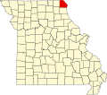
Winchester, Clark County, Missouri

Last updated

Winchester is an unincorporated community in eastern Clark County, in the U.S. state of Missouri. [1]

The community is located on Missouri Route H 1.5 miles west of US Route 61. Wayland is approximately five miles to the north and the community of Antioch is four miles to the west. [2]

History

Winchester was platted in 1837, and most likely was named after Winchester, Virginia. [3] A post office called Winchester was established in 1840, and remained in operation until 1905. [4]

Related Research Articles

<span class="mw-page-title-main">Clark County, Missouri</span> County in Missouri, United States

Clark County is a county located in the U.S. state of Missouri. As of the 2020 census, its population was 6,634. Its county seat is Kahoka. The county was organized December 16, 1836 and named for William Clark, leader of the Lewis and Clark Expedition and later Governor of Missouri Territory.

<span class="mw-page-title-main">St. Patrick, Missouri</span>

St. Patrick or Saint Patrick is an unincorporated community in southern Clark County, Missouri, United States. It is located approximately ten miles northwest of Canton on Route 81. The community was founded in 1833 by Irish immigrants, who named it after the patron saint of Ireland, Saint Patrick. Today, it is best known as the home of the Shrine of St. Patrick, a medieval-inspired Catholic church.

Concord is an unincorporated community in northern Callaway County, in the U.S. state of Missouri. The community is located approximately four miles west-northwest of Auxvasse and about one-half mile north of Missouri Route E.

Garrett is an extinct town in eastern Callaway County, in the U.S. state of Missouri. The community and Garrett Cemetery are on Missouri Route K, one-half mile west of the Callaway-Montgomery county line. The community of Readsville is approximately 3.5 miles to the west and Americus is about 4.5 miles to the east on route K.

Shamrock is an unincorporated community in Shamrock Township in the northeast corner of Callaway County, in the U.S. state of Missouri. The community is on Missouri Route B two miles west of the Loutre River. Auxvasse is ten miles to the west, Montgomery City is about nine miles east and Williamsburg is five miles south.

Anson is an unincorporated community in northern Clark County, in the U.S. state of Missouri.

Ashton is an unincorporated community in Clark County, in the U.S. state of Missouri.

Cedar Creek is a stream in Clark County in the U.S. state of Missouri. It is a tributary of the Des Moines River.

Neeper is an unincorporated community in Clark County, in the U.S. state of Missouri.

Sugar Creek is a stream in Clark and Lewis Counties in the U.S. state of Missouri. It is a tributary of the Wyaconda River.

Cherry Valley is an unincorporated community in Crawford County, in the U.S. state of Missouri.

Coulstone is an unincorporated community in western Dent County, in the U.S. state of Missouri.

<span class="mw-page-title-main">Joy, Missouri</span>

Joy is an unincorporated community in southwest Dent County, in the U.S. state of Missouri.

Beemont is an unincorporated community in western Franklin County, in the U.S. state of Missouri. The community is located on Missouri Route ZZ on the west side of Boeuf Creek one half mile east of the Franklin-Gasconade county line.

Clover Bottom is an unincorporated community in Franklin County, in the U.S. state of Missouri. The community is at the intersection of routes YY and AJ approximately 3.5 miles west of Krakow.

Chapel is an unincorporated community in northeastern Howell County, in the U.S. state of Missouri. The community is located on county road 2680, east of Missouri Route W, and approximately four miles south-southeast of Mountain View. The Chapel Hill Church and historic school lie just west of Route W.

Tavern Creek is a stream in Miller and Pulaski counties in the U.S. state of Missouri. It is a tributary of the Osage River. The stream headwaters are at 37°54′42″N92°22′19″W and the confluence with the Osage is at 38°19′04″N92°17′24″W.

Big Creek is a stream in northern Ralls County in the U.S. state of Missouri. It is a tributary of the Salt River.

Varvol is an unincorporated community in southern Texas County, in the U.S. state of Missouri. The community is on the South Prong of Jacks Fork at the intersection of Missouri Route HH and Varvel Road. The community of Sargent is approximately 3.5 miles to the west on Varvel Road and Willow Springs in adjacent Howell County is about seven miles south on route HH and Missouri Route 137. Varvel School was about three miles east along the north bank of the river.

Venable is an unincorporated community in northwest Texas County, in the U.S. state of Missouri.

References

  1. U.S. Geological Survey Geographic Names Information System: Winchester, Clark County, Missouri
  2. Missouri Atlas & Gazetteer, DeLorme, First edition, 1998, p. 17 ISBN   0899332242
  3. "Clark County Place Names, 1928–1945 (archived)". The State Historical Society of Missouri. Archived from the original on 2016-06-24. Retrieved 19 September 2016.
  4. "Post Offices". Jim Forte Postal History. Retrieved 19 September 2016.

40°19′04″N91°36′41″W / 40.31778°N 91.61139°W / 40.31778; -91.61139