Waterloo, Missouri | |
|---|---|
 Waterloo | |
| Coordinates: 40°26′58″N91°40′08″W / 40.44944°N 91.66889°W | |
| Country | United States |
| State | Missouri |
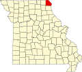
| County | Clark |
| Elevation | 554 ft (169 m) |
| Time zone | UTC-6 (Central (CST)) |
| • Summer (DST) | UTC-5 (CDT) |
| Area code | 660 |
| GNIS feature ID | 755469 [1] |
Waterloo is a community in Clark County, Missouri, United States. [1] The community is located on a sharp meander in the Fox River. Nearby towns include Kahoka (3 miles southwest), Revere (2.5 miles north) and Wayland (6 miles southeast). [2]
A post office called Waterloo was established in 1837, and remained in operation until 1876. [3] Waterloo held the first county seat. [4]