St. Patrick, Missouri

Last updated
MOMap-doton-St. Patrick.png

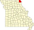
St. Patrick or Saint Patrick is an unincorporated community in southern Clark County, Missouri, United States. [1] It is located approximately ten miles northwest of Canton on Route 81. The community was founded in 1833 by Irish immigrants, who named it after the patron saint of Ireland, Saint Patrick. Today, it is best known as the home of the Shrine of St. Patrick, a medieval-inspired Catholic church. [2]

St. Patrick is part of the Fort Madison Keokuk, IA-MO Micropolitan Statistical Area.

St. Patrick was originally called St. Marysville, and under the latter name was platted in 1857. [3]

Notes

  1. U.S. Geological Survey Geographic Names Information System: St. Patrick, Missouri
  2. Adam Farley, "Irish in the Heartland: St. Patrick, Missouri" Irish America April/May 2013 online
  3. "Clark County Place Names, 1928–1945 (archived)". The State Historical Society of Missouri. Archived from the original on 24 June 2016. Retrieved 19 September 2016.{{cite web}}: CS1 maint: bot: original URL status unknown (link)

Coordinates: 40°15′50″N91°37′38″W / 40.2638°N 91.6273°W / 40.2638; -91.6273


Related Research Articles

<span class="mw-page-title-main">Clark County, Missouri</span> County in Missouri, United States

Clark County is a county located in the U.S. state of Missouri. As of the 2020 census, its population was 6,634. Its county seat is Kahoka. The county was organized December 16, 1836 and named for William Clark, leader of the Lewis and Clark Expedition and later Governor of Missouri Territory.

Athens is an unincorporated community in the now inactive township of Grant in Clark County, Missouri, United States. It is southeast of the Battle of Athens State Historic Site.

Shamrock is an unincorporated community in Shamrock Township in the northeast corner of Callaway County, in the U.S. state of Missouri. The community is on Missouri Route B two miles west of the Loutre River. Auxvasse is ten miles to the west, Montgomery City is about nine miles east and Williamsburg is five miles south.

Acasto is an unincorporated community in Clark County, in the U.S. state of Missouri.

Anson is an unincorporated community in northern Clark County, in the U.S. state of Missouri.

Antioch is an unincorporated community in Clark County, in the U.S. state of Missouri.

Ashton is an unincorporated community in Clark County, in the U.S. state of Missouri.

Cedar Creek is a stream in Clark County in the U.S. state of Missouri. It is a tributary of the Des Moines River.

Chambersburg is an unincorporated community in Clark County, in the U.S. state of Missouri.

Clark City is an unincorporated community in Clark County, in the U.S. state of Missouri.

Dumas is an unincorporated community in Clark County, in the U.S. state of Missouri. The community was located along the banks of Dumas Creek just west (upstream) of the confluence with the Des Moines River. The Atchison, Topeka and Santa Fe Railroad line was adjacent to the community site. Revere lies to the southwest of the location and Argyle, Iowa lies to the northeast along the rail line.

Fairmont is an unincorporated community in Clark County, in the U.S. state of Missouri.

Gregory Landing is an unincorporated community in Clark County, in the U.S. state of Missouri.

Neeper is an unincorporated community in Clark County, in the U.S. state of Missouri.

Peaksville is an unincorporated community in Clark County, in the U.S. state of Missouri.

Sugar Creek is a stream in Clark and Lewis Counties in the U.S. state of Missouri. It is a tributary of the Wyaconda River.

Union is an unincorporated community in Clark County, in the U.S. state of Missouri.

Winchester is an unincorporated community in eastern Clark County, in the U.S. state of Missouri.

Union Township is an inactive township in Clark County, in the U.S. state of Missouri.

Wyaconda Township is an inactive township in Clark County, in the U.S. state of Missouri.