Winchuck River

Last updated
Winchuck River
Winchuck River.jpg
The Winchuck River
Name origin:Uncertain. Possibly the Chinook Jargon term for windy water. Possibly the local native name for woman. [1]
Country United States
State Oregon
County Curry County, Oregon
and Del Norte County, California
Sourceconfluence of Bear and Salmon creeks
 - locationCurry County, Siskiyou National Forest , Oregon
 - elevation164 ft (50 m) [2]
 - coordinates 42°01′09″N124°06′20″W / 42.01917°N 124.10556°W / 42.01917; -124.10556   [3]
Mouth Pacific Ocean
 - location Crissey Field State Recreation Site, Curry County, Oregon
 - elevation7 ft (2 m) [3]
 - coordinates 42°00′18″N124°12′55″W / 42.00500°N 124.21528°W / 42.00500; -124.21528 Coordinates: 42°00′18″N124°12′55″W / 42.00500°N 124.21528°W / 42.00500; -124.21528   [3]
Length10 mi (16 km) [4]
Basin71.3 sq mi (185 km2) [5]
Discharge
 - average494 cu ft/s (14 m3/s) [4]
USA Oregon location map.svg
Red pog.svg
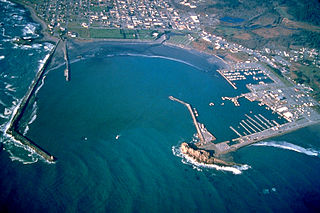
Location of the mouth of the Winchuck River in Oregon

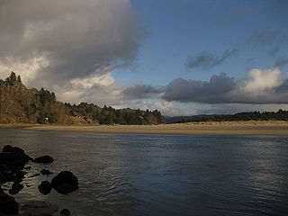
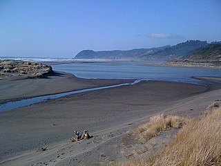
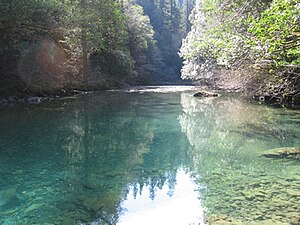
The Winchuck River (Tolowa: duu-sr-xuu-shi taa-ghin-li~' [6] ) is a short coastal stream that runs through the Rogue River–Siskiyou National Forest to the Pacific Ocean in the U.S. states of Oregon and California. Flowing generally west from its origin near Elk Mountain, the river enters the sea at Crissey Field State Recreation Site, [7] about 12 mile (0.80 km) north of the OregonCalifornia border and about 5 miles (8 km) south of Brookings. [8]

The Tolowa language is a member of the Pacific Coast subgroup of the Athabaskan language family. Together with three other closely related languages it forms a distinctive Oregon Athabaskan cluster within the subgroup.

Rogue River–Siskiyou National Forest United States national forest in Oregon

The Rogue River–Siskiyou National Forest is a United States National Forest in the U.S. states of Oregon and California. The formerly separate Rogue River and Siskiyou National Forests were administratively combined in 2004. Now, the Rogue River–Siskiyou National Forest ranges from the crest of the Cascade Range west into the Siskiyou Mountains, covering almost 1.8 million acres (7,300 km2). Forest headquarters are located in Medford, Oregon.

Pacific Ocean Ocean between Asia and Australia in the west, the Americas in the east and Antarctica or the Southern Ocean in the south.

The Pacific Ocean is the largest and deepest of Earth's oceanic divisions. It extends from the Arctic Ocean in the north to the Southern Ocean in the south and is bounded by Asia and Australia in the west and the Americas in the east.

Contents

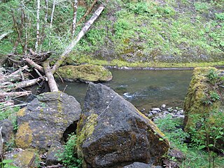
Formed by the confluence of Fourth of July Creek and Bear Creek in southern Curry County, the river flows generally west. Just below the source, Salmon Creek enters from the left, then Elk Creek and Deer Creek enter from the right. Further downstream, the Winchuck receives Moser Creek and the South Fork Winchuck River, both from the left. The river then leaves Oregon, flowing in Del Norte County, California, for a short distance before re-entering Oregon. The Winchuck passes under U.S. Route 101 in Oregon just before reaching the ocean. Winchuck River Road runs along or near the north side of the river for much of its course. [9]

Curry County, Oregon County in the United States

Curry County is a county in the U.S. state of Oregon. As of the 2010 census, the population was 22,364. The county seat is Gold Beach. The county is named for George Law Curry, a governor of the Oregon Territory.

Del Norte County, California County in California ----

Del Norte County is a county at the far northwest corner of the U.S. state of California, along the Pacific Ocean adjacent to the Oregon border. As of the 2010 census, the population was 28,610. The county seat and only incorporated city is Crescent City. Del Norte was pioneered and settled by Azorean Portuguese explorers and dairy farmers, which may account for the local pronunciation of the county name. Residents pronounce the county name as Del Nort, not Del Nor-teh as would be expected in Spanish.

U.S. Route 101 in Oregon highway in Oregon

U.S. Route 101 (US 101), is a major north–south U.S. Highway in Oregon that runs through the state along the coastline near the Pacific Ocean. It runs from the California border, south of Brookings, to the Washington state line on the Columbia River, between Astoria, Oregon, and Megler, Washington.

The main stem and tributaries support chinook and coho salmon, steelhead, and sea-run coastal cutthroat trout. [10] Access for fishing is limited, especially along the lower stretches of the river. Fishing from boats is not allowed, but Winchuck River Road provides public access in places. [11]

Chinook salmon species of fish

The Chinook salmon is the largest species in the Pacific salmon genus Oncorhynchus. The common name refers to the Chinookan peoples. Other vernacular names for the species include king salmon, Quinnat salmon, spring salmon, chrome hog, and Tyee salmon. The scientific species name is based on the Russian common name chavycha (чавыча).

Coho salmon species of fish

The coho salmon is a species of anadromous fish in the salmon family, one of the several species of Pacific salmon. Coho salmon are also known as silver salmon or "silvers". The scientific species name is based on the Russian common name kizhuch (кижуч).

Rainbow trout species of trout

The rainbow trout is a trout and species of salmonid native to cold-water tributaries of the Pacific Ocean in Asia and North America. The steelhead is an anadromous (sea-run) form of the coastal rainbow trout(O. m. irideus) or Columbia River redband trout (O. m. gairdneri) that usually returns to fresh water to spawn after living two to three years in the ocean. Freshwater forms that have been introduced into the Great Lakes and migrate into tributaries to spawn are also called steelhead.

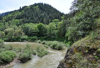
Flora in the watershed's forests include Douglas-fir, bigleaf maple, and madrone, typical of the Southern Oregon Coast Range, the coastal Siskiyou Mountains, and the Redwoods Zone. [12] Most of Oregon's remaining coast redwood forest lies within the Winchuck drainage. [10] Sensitive fauna in the watershed include the spotted owl and marbled murrelet. [5]

<i>Acer macrophyllum</i> species of plant

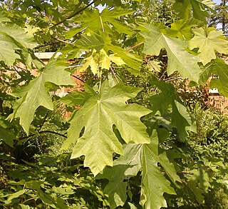
Acer macrophyllum, the bigleaf maple or Oregon maple, is a large deciduous tree in the genus Acer.

<i>Arbutus</i> genus of plants

Arbutus is a genus of 12 accepted species of flowering plants in the family Ericaceae, native to warm temperate regions of the Mediterranean, western Europe, the Canary Islands and North America. The name Arbutus was taken from Latin, where it referred to Arbutus unedo.

Southern Oregon Coast Range

The Southern Oregon Coast Range is the southernmost section of the Oregon Coast Range, in the Pacific Coast Ranges, located in the southwest portion of the state of Oregon, United States, roughly between the Umpqua River and the middle fork of the Coquille River, beyond which are the Klamath Mountains. To the east is the Umpqua Valley and to the west the Pacific Ocean. This approximately 55-mile (89 km)-long mountain range contains mountains as high as 3,547 feet (1,081 m) for Bone Mountain. The mountains are known locally in the Roseburg area as the Callahan Mountains, or simply as The Callahans.

Related Research Articles

Coos River Gold

The Coos River flows for about 5 miles (8.0 km) into Coos Bay along the Pacific coast of southwest Oregon in the United States. Formed by the confluence of its major tributaries, the South Fork Coos River and the Millicoma River, it drains an important timber-producing region of the Southern Oregon Coast Range. The course of the main stem and the major tributaries is generally westward from the coastal forests to the eastern end of Coos Bay near the city of Coos Bay.

Elk River (Oregon) river in southwestern Oregon in the United States

The Elk River is in southwestern Oregon in the United States. About 29 miles (47 km) long, the river drains a remote 92-square-mile (240 km2) area of the Coast Range into the Pacific Ocean.

Salmon River (Lincoln County, Oregon) river in Lincoln County, Oregon

The Salmon River flows from the Central Oregon Coast Range to the Pacific Ocean coast of northwest Oregon in the United States. About 24 miles (39 km) long, it begins and ends in Lincoln County but also flows briefly through western Polk and southern Tillamook counties. Much of its course lies within the Siuslaw National Forest.

Nestucca River river in the United States of America

The Nestucca River flows for about 57 miles (92 km) through forests near the Pacific coast of northwest Oregon in the United States. It drains a timber-producing area of the Northern Oregon Coast Range west of Portland.

Sixes River river in the United States of America

The Sixes River flows about 31 miles (50 km) through coastal forests in southwestern Oregon in the United States. It drains a rugged region of the Klamath Mountains along the Pacific north of Port Orford.

Sycan River river in the United States of America

The Sycan River is a tributary, about 75 miles (121 km) long, of the Sprague River in the U.S. state of Oregon. The headwaters are in highlands in the Fremont National Forest south of Summer Lake. The river runs northwest into the Sycan Marsh in southern Lake County, from which it flows generally southwest to join the Sprague River near Beatty, in Klamath County. The uppermost 59 miles (95 km) of the stream are part of the National Wild and Scenic Rivers System.

Umatilla River tributary of the Columbia River in Oregon

The Umatilla River is an 89-mile (143 km) tributary of the Columbia River in the U.S. state of Oregon. Draining a basin of 2,450 square miles (6,300 km2), it enters the Columbia near the city of Umatilla in the northeastern part of the state. In downstream order, beginning at the headwaters, major tributaries of the Umatilla River are the North Fork Umatilla River and the South Fork Umatilla River, then Meacham, McKay, Birch, and Butter creeks.

Catherine Creek river in the United States of America

Catherine Creek is a 32.4-mile-long (52.1 km) creek in northeastern Oregon, United States. A tributary of the Grande Ronde River, it is the second-longest stream in the Grande Ronde Valley. Originating in the foothills of the Wallowa Mountains, it flows generally northwest through Catherine Creek State Park and the city of Union before joining the river.

South Fork Rogue River tributary of the Rogue River in Oregon

The South Fork Rogue River is a 25-mile (40 km) tributary of the Rogue River in the U.S. state of Oregon. Rising in the Sky Lakes Wilderness in the Cascade Range, it flows generally northeast through the Rogue River – Siskiyou National Forest to meet the Rogue River downstream of Prospect and slightly upstream of Lost Creek Lake.

Muddy Fork (Oregon) river in the United States of America

Muddy Fork is a tributary, about 6 miles (10 km) long, of the Sandy River in the U.S. state of Oregon. Arising at the base of Sandy Glacier on the west slope of Mount Hood, it flows west through the Mount Hood Wilderness in the Mount Hood National Forest. It joins the Sandy River in Old Maid Flat, about 5 miles (8 km) northeast of Rhododendron. The stream offers limited fishing for coastal cutthroat trout.

North Fork Malheur River river in the United States of America

The North Fork Malheur River is a 59-mile (95 km) tributary of the Malheur River in eastern Oregon in the United States. Rising in Big Cow Burn in the Blue Mountains, it flows generally south to join the larger river at Juntura. The upper 25.5 miles (41.0 km) of the river have been designated Wild and Scenic. This part of the river basin offers camping, hiking, and fishing opportunities in a remote forest setting. The lower river passes through Beulah Reservoir, which stores water for irrigation and has facilities for boaters.

Union Creek (Rogue River)

Union Creek is a 15-mile (24 km) long tributary of the Rogue River in the U.S. state of Oregon. Beginning west of Union Peak in the Cascade Range, it flows through the Rogue River – Siskiyou National Forest to meet the Rogue at Union Creek and the Union Creek Historic District.

Pistol River river in the United States of America

The Pistol River is a coastal stream that meanders for 21 miles (34 km) through the Southern Oregon Coast Range to the Pacific Ocean near the unincorporated community of Pistol River in the U.S. state of Oregon. Flowing generally southwest from its origin near Sugarloaf Mountain in the Siskiyou National Forest, the river enters the sea at Pistol River State Scenic Viewpoint, 10 miles (16 km) south of Gold Beach. The river received its name after pioneer James Mace lost his pistol in it in 1853.

Millicoma River river in the United States of America

The Millicoma River is a coast stream, about 8.5 miles (13.7 km) long, east of Coos Bay in the U.S. state of Oregon. Formed by the confluence of the East Fork Millicoma River and the West Fork Millicoma River at Allegany, it meanders across relatively flat land to meet the South Fork Coos River, with which it forms the Coos River.

West Fork Millicoma River river in the United States of America

The West Fork Millicoma River is a tributary, about 34 miles (55 km) long, of the Millicoma River in the U.S. state of Oregon. Rising in northeastern Coos County near the Douglas County line, it flows generally southwest through the Elliott State Forest of the Southern Oregon Coast Range to the community of Allegany. There it joins the East Fork Millicoma River to form the Millicoma. In turn, the Millicoma, which is only about 9 miles (14 km) long, joins the South Fork Coos River to form the Coos River. The Coos River, itself only about 5 miles (8 km) long, empties into the eastern end of Coos Bay, which connects to the Pacific Ocean.

South Fork Coos River river in the United States of America

The South Fork Coos River is a tributary, about 32 miles (51 km) long, of the Coos River in the U.S. state of Oregon. Formed by the confluence of the Williams River and Tioga Creek, it begins in eastern Coos County near the Douglas County line and flows generally northwest through the Southern Oregon Coast Range. East of the city of Coos Bay, it joins the Millicoma River to form the Coos River. This larger river, only about 5 miles (8 km) long, empties into the eastern end of Coos Bay, which connects to the Pacific Ocean.

South Fork McKenzie River tributary of the McKenzie River in Oregon

The South Fork McKenzie River is a tributary, about 31 miles (50 km) long, of the McKenzie River in the U.S. state of Oregon. It begins at about 4,500 feet (1,400 m) above sea level near Mink Lake in the Three Sisters Wilderness of the Cascade Range. Flowing northwest within Lane County, it meets the McKenzie River about 60 miles (97 km) from the larger river's confluence with the Willamette River.

North Fork Siuslaw River river in the United States of America

The North Fork Siuslaw River is a tributary of the Siuslaw River in Lane County in the United States state of Oregon. It is formed by the confluence of Sam Creek and West Branch in the Siuslaw National Forest of the Central Oregon Coast Range. The former community of Pawn was once at the juncture of the two creeks. From here, the river flows about 2 miles (3 km) southeast, then about 25 miles (40 km) southwest to meet the main stem 1.2 miles (1.9 km) east of Florence.

South Fork Burnt River river in the United States of America

The South Fork Burnt River is a tributary of the Burnt River in Baker County in the U.S. state of Oregon. Its headwaters lie in the Monument Rock Wilderness and the Wallowa–Whitman National Forest of the Blue Mountains. It flows generally northeast for about to meet the main stem at Unity Reservoir, north of Unity. The river, about 12 miles (19 km) long, crosses under U.S. Route 26 about 3 miles (5 km) northwest of Unity.

Middle Fork Coquille River river in the United States of America

The Middle Fork Coquille River is a tributary, about 40 miles (64 km) long, of the South Fork Coquille River in the U.S. state of Oregon. It begins near Camas Mountain in Douglas County in the Southern Oregon Coast Range. It flows generally south, bypassing the community of Camas Valley while passing through the valley of the same name, then curves west and north to Remote in Coos County. The Middle Fork then flows generally west, passes by the small community of Bridge, and meets the South Fork near Myrtle Point. The confluence with the South Fork is 41 miles (66 km) by water to where the main stem of the Coquille River enters the Pacific Ocean at Bandon.

References

  1. McArthur, pp. 104950
  2. Source elevation derived from Google Earth search using GNIS source coordinates.
  3. 1 2 3 "Winchuck River". Geographic Names Information System. United States Geological Survey. November 28, 1980. Retrieved April 12, 2011.
  4. 1 2 Palmer, Tim (2014). Field Guide to Oregon Rivers. Corvallis: Oregon State University Press. pp. 122–23. ISBN   978-0-87071-627-0.
  5. 1 2 "Winchuck River". United States Forest Service. Retrieved April 24, 2014.
  6. "Siletz Talking Dictionary". Living Tongues Institute for Endangered Languages. 2007. Retrieved June 4, 2012.
  7. Oregon Atlas and Gazetteer (Map) (1991 ed.). DeLorme Mapping. § 17. ISBN   978-0-89933-347-2.
  8. McGuire, p. 1
  9. United States Geological Survey. "United States Geological Survey Topographic Map". TopoQuest. Retrieved April 12, 2011. Relevant map quadrangles from mouth to source are Mount Emily, Smith River, and Fourth of July Creek.
  10. 1 2 "East Fork Winchuck River, Curry County". Western Rivers Conservancy. Retrieved April 14, 2011.
  11. Sheehan, p. 114
  12. McGuire, pp. 1320

Works cited

International Standard Book Number Unique numeric book identifier

The International Standard Book Number (ISBN) is a numeric commercial book identifier which is intended to be unique. Publishers purchase ISBNs from an affiliate of the International ISBN Agency.