
The United States Census Bureau (USCB), officially the Bureau of the Census, is a principal agency of the U.S. Federal Statistical System, responsible for producing data about the American people and economy. The Census Bureau is part of the U.S. Department of Commerce and its director is appointed by the President of the United States.

The United States had an official estimated resident population of 333,287,557 on July 1, 2022, according to the U.S. Census Bureau. This figure includes the 50 states and the District of Columbia but excludes the population of five unincorporated U.S. territories as well as several minor island possessions. The United States is the third most populous country in the world. The Census Bureau showed a population increase of 0.4% for the twelve-month period ending in July 2022, below the world average annual rate of 0.9%. The total fertility rate in the United States estimated for 2022 is 1.665 children per woman, which is below the replacement fertility rate of approximately 2.1.
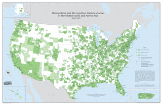
In the United States, a metropolitan statistical area (MSA) is a geographical region with a relatively high population density at its core and close economic ties throughout the region. Such regions are not legally incorporated as a city or town would be and are not legal administrative divisions like counties or separate entities such as states. That makes the precise definition of any given metropolitan area vary with the source. The statistical criteria for a standard metropolitan area were defined in 1949 and redefined as a metropolitan statistical area in 1983.

Park County is a county in the U.S. state of Montana. At the 2020 census, the population was 17,191. Its county seat is Livingston. A small part of Yellowstone National Park is in the southern part of the county.
A census-designated place (CDP) is a concentration of population defined by the United States Census Bureau for statistical purposes only.
United States micropolitan statistical areas, as defined by the Office of Management and Budget (OMB), are labor market and statistical areas in the United States centered on an urban cluster with a population of at least 10,000 but fewer than 50,000 people. The micropolitan area designation was created in 2003. Like the better-known metropolitan statistical areas, a micropolitan area is a geographic entity used for statistical purposes based on counties and county equivalents. The OMB has identified 543 micropolitan areas in the United States.
Combined statistical area (CSA) is a United States Office of Management and Budget (OMB) term for a combination of adjacent metropolitan (MSA) and micropolitan statistical areas (µSA) across the 50 U.S. states and the territory of Puerto Rico that can demonstrate economic or social linkage. CSAs were first designated in 2003. The OMB defines a CSA as consisting of various combinations of adjacent metropolitan and micropolitan areas with economic ties measured by commuting patterns. These areas that combine retain their own designations as metropolitan or micropolitan statistical areas within the larger combined statistical area.

The United States has a racially and ethnically diverse population. At the federal level, race and ethnicity have been categorized separately. The most recent United States census officially recognized seven racial categories, as well as people of two or more races. The Census Bureau also classified respondents as "Hispanic or Latino" or "Not Hispanic or Latino", identifying as an ethnicity, which comprises the largest minority group in the nation. The census also asked an "Ancestry Question," which covers the broader notion of ethnicity, in the 2000 census long form and the 2010 American Community Survey; the question worded differently on "origins" will return in the 2020 census.
The United States census of 1990, conducted by the Census Bureau, was the first census to be directed by a woman, Barbara Everitt Bryant. It determined the resident population of the United States to be 248,709,873, an increase of 9.8 percent over the 226,545,805 persons enumerated during the 1980 census.
The United States census of 1980, conducted by the Census Bureau, determined the resident population of the United States to be 226,545,805, an increase of 11.4 percent over the 203,184,772 persons enumerated during the 1970 census. It was the first census in which a state—California—recorded a population of 20 million people, as well as the first in which all states recorded populations of over 400,000.
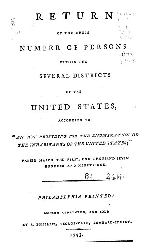
The 1790 United States census was the first decennial United States census of the whole United States. It recorded the population of the United States as of Census Day, August 2, 1790, as mandated by Article 1, Section 2 of the United States Constitution and applicable laws. In the first census, the population of the United States was enumerated to be 3,929,214 inhabitants
The United States census of 1920, conducted by the Census Bureau during one month from January 5, 1920, determined the resident population of the United States to be 106,021,537, an increase of 15.0 percent over the 92,228,496 persons enumerated during the 1910 census.
The United States census of 1950, conducted by the Census Bureau, determined the resident population of the United States to be 150,697,361, an increase of 14.5 percent over the 131,669,275 persons enumerated during the 1940 census.

Hillcrest is a suburb in the City of Logan, Queensland, Australia. In the 2016 census, Hillcrest had a population of 5,626 people.

Americans are the citizens and nationals of the United States of America. The United States is home to people of many racial and ethnic origins; consequently, American culture and law do not equate nationality with race or ethnicity, but with citizenship and an oath of permanent allegiance.

