Fenham is an area of the west-end of Newcastle upon Tyne, in the county of Tyne and Wear, England. It lies to the west of the city centre, and is bounded on the north and east by a large area of open land known as the Town Moor. To the south lies Benwell, West Denton lies to the west, Blakelaw and Cowgate to the north, and Arthur's Hill and Spital Tongues to the east. Until 1974 it was in Northumberland.
Newcastle upon Tyne Central was a constituency represented in the House of Commons of the UK Parliament from 2010 until its abolition for the 2024 general election by Chi Onwurah of the Labour Party. As with all constituencies since 1950, the constituency elected one Member of Parliament (MP) by the first past the post system of election at least every five years.

Newcastle upon Tyne North is a constituency represented in the House of Commons of the UK Parliament since 2010 by Catherine McKinnell of the Labour Party.

Elswick is a district and electoral ward of the city and metropolitan borough of Newcastle upon Tyne, in the county of Tyne and Wear, England, 1.9 miles west of the city centre, bordering the River Tyne. Historically in Northumberland, Elswick became part of Newcastle upon Tyne in 1835. Elswick is home to the Newcastle Utilita Arena; and Newcastle College, with approximately 45,000 students.

Walkergate is an area and electoral ward in the city of Newcastle upon Tyne, England. It is in the east of the city, north of Walker proper, east of the Heaton area and west of Wallsend. Areas within the Walkergate ward include Daisy Hill, Eastfield, Walkerdene and Walkerville. Walkergate Metro station which was opened in 1982 serves the area. This replaced the previous railway station on the same site which was originally known as Walker station from 1839 to 1889 when it was renamed Walker Gate station.

Newcastle City Council is the local authority for the city of Newcastle upon Tyne in the ceremonial county of Tyne and Wear in North East England. Newcastle has had a council from medieval times, which has been reformed on numerous occasions. Since 1974 the council has been a metropolitan borough council. In 2024 the council became a member of the North East Combined Authority. The council is based at Newcastle Civic Centre.

Byker is a district in the east of the city and metropolitan borough of Newcastle upon Tyne, in the county of Tyne and Wear, England. Home to the Byker Wall estate, made famous by TV series Byker Grove, Byker's population was recorded at 12,206 in the 2011 census. Byker is bordered by Heaton to the north and by Shieldfield to the north east. Until 1974 it was in Northumberland.

Woolsington is a village in, and civil parish of, Newcastle upon Tyne, England. It is located north-west of the city centre, covering a large geographical area. It was also formerly an electoral ward, although the ward was slightly larger than the civil parish, extending slightly further south. The parish also includes Newbiggin Hall, Woolsington village and Newcastle Airport. It had a population of 11,160 as of the 2011 Census.
Newcastle City Council elections are generally held three years out of every four, with a third of the council being elected each time. Newcastle City Council is the local authority for the metropolitan borough of the Newcastle upon Tyne in Tyne and Wear, England. Since the last boundary changes in 2018, 78 councillors have been elected from 26 wards.

Newcastle upon Tyne East was a constituency of the House of Commons of the UK Parliament. It was held by Nick Brown, an independent formerly of the Labour Party, from its recreation in 2010 until its abolition for the 2024 general election.

Arthur's Hill is a district of Newcastle upon Tyne. It lies approximately 1 mile west of Newcastle City Centre. It is bordered by Fenham to the west, Elswick to the south, and Spital Tongues to the north west. It gives name to a Newcastle City Council electoral ward with a population of 14,507. The area was part of the Westgate and Wingrove electoral wards up until 2018.
North Heaton is a ward of Newcastle City Council in Newcastle upon Tyne, England. It covers the northern part of the Heaton district as well as High Heaton. The Ward population at the 2011 Census was 9,574.
South Heaton was a ward of Newcastle City Council in Newcastle upon Tyne, England. It covers the southern part of the Heaton district, and some north eastern parts of neighbouring Byker. It was abolished in 2018 and replaced by a new ward named Heaton.
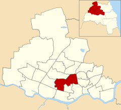
Benwell and Scotswood is an electoral ward of Newcastle upon Tyne in North East England. The ward encompasses the Benwell and Scotswood housing areas, as well as the Newcastle Business Park, which is located on the banks of the River Tyne and houses offices of companies such as British Airways and the Automobile Association. The population of the ward is 13,759, which is 5.3% of the total population of Newcastle upon Tyne. Car ownership in the area is 45.1%, lower than the city average of 54.7%. The 2011 Census gave a population of 12,694.

Lemington is an area and electoral ward of Newcastle upon Tyne in North East England.

Westgate was an electoral ward of Newcastle upon Tyne, in the county of Tyne and Wear, England from 2004 to 2018. The population of the ward taken at the 2011 Census was 10,059.
Spital Tongues is a district of Newcastle upon Tyne, located due north-west of the Newcastle City Centre. Its unusual name is believed to be derived from spital – a corruption of the word hospital, commonly found in British place names - and tongues, meaning outlying pieces of land. North of Spital Tongues is the Town Moor, while Castle Leazes and Leazes Park are to the East.

Newcastle General Hospital (NGH) was for many years the main hospital for the city of Newcastle upon Tyne, England. As part of Newcastle upon Tyne Hospitals NHS Foundation Trust moving from three to two key sites, the hospital was closed and the majority of services transferred to the city's other two hospitals, the Royal Victoria Infirmary and the Freeman Hospital. The Accident and Emergency Department and Intensive Care closed on 16 November 2010. A walk-in centre for minor ailments and injuries remained on the site.

Newcastle Corporation Tramways operated a tramway service in Newcastle upon Tyne between 1901 and 1950.