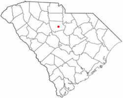
Winnsboro Mills, South Carolina | |
---|---|
Coordinates: 34°21′24″N81°4′58″W / 34.35667°N 81.08278°W | |
Country | United States |
State | South Carolina |
County | Fairfield |
Area | |
• Total | 2.57 sq mi (6.66 km2) |
• Land | 2.57 sq mi (6.66 km2) |
• Water | 0.00 sq mi (0.00 km2) |
Elevation | 561 ft (171 m) |
Population | |
• Total | 1,632 |
• Density | 634.77/sq mi (245.06/km2) |
Time zone | UTC-5 (Eastern (EST)) |
• Summer (DST) | UTC-4 (EDT) |
ZIP code | 29180 |
Area code(s) | 803 and 839 |
FIPS code | 45-78505 [4] |
GNIS feature ID | 1231932 [2] |
Winnsboro Mills is an unincorporated community and census-designated place (CDP) in Fairfield County, South Carolina, United States. The population was 1,898 at the 2010 census, [5] down from 2,263 at the 2000 census. It is part of the Columbia, South Carolina Metropolitan Statistical Area.
Winnsboro Mills is located southeast of the center of Fairfield County at 34°21′24″N81°4′58″W / 34.35667°N 81.08278°W (34.356734, -81.082834). [6] It is bordered to the north by the town of Winnsboro, the county seat. U.S. Route 321 Business (Columbia Road) is the main road through the community.
According to the United States Census Bureau, the CDP has a total area of 2.6 square miles (6.8 km2), all of it land. [5]
Census | Pop. | Note | %± |
---|---|---|---|
2020 | 1,632 | — | |
U.S. Decennial Census [7] |
As of the census [4] of 2000, there were 2,263 people, 885 households, and 593 families residing in the CDP. The population density was 819.9 inhabitants per square mile (316.6/km2). There were 1,005 housing units at an average density of 364.1 per square mile (140.6/km2). The racial makeup of the CDP was 54.75% White, 41.32% African American, 0.40% Native American, 0.53% Asian, 1.86% from other races, and 1.15% from two or more races. Hispanic or Latino of any race were 3.31% of the population.
There were 885 households, out of which 35.0% had children under the age of 18 living with them, 41.5% were married couples living together, 20.0% had a female householder with no husband present, and 32.9% were non-families. 29.5% of all households were made up of individuals, and 12.8% had someone living alone who was 65 years of age or older. The average household size was 2.55 and the average family size was 3.16.
In the CDP, the population was spread out, with 29.1% under the age of 18, 10.3% from 18 to 24, 28.7% from 25 to 44, 19.8% from 45 to 64, and 12.1% who were 65 years of age or older. The median age was 32 years. For every 100 females, there were 91.9 males. For every 100 females age 18 and over, there were 87.2 males.
The median income for a household in the CDP was $25,160, and the median income for a family was $28,357. Males had a median income of $25,305 versus $19,597 for females. The per capita income for the CDP was $12,841. About 16.7% of families and 22.2% of the population were below the poverty line, including 31.8% of those under age 18 and 25.5% of those age 65 or over.
Fairfield County is a county located in the U.S. state of South Carolina. As of the 2020 census, its population was 20,948. Its county seat is Winnsboro.
Saxapahaw is a census-designated place (CDP) and unincorporated area in Alamance County, North Carolina, United States. It is part of the Burlington, North Carolina Metropolitan Statistical Area. The population was 1,648 at the 2010 census.
Royal Pines is a census-designated place (CDP) in Buncombe County, North Carolina, United States. The population was 4,272 at the 2010 census. It is part of the Asheville Metropolitan Statistical Area.
Eureka Mill is a census-designated place (CDP) in Chester County, South Carolina, United States. The population was 1,476 at the 2010 census, down from 1,737 at the 2000 census.
Gayle Mill is a census-designated place (CDP) in Chester County, South Carolina, United States. The population was 913 at the 2010 census, down from 1,094 at the 2000 census.
Ridgeway is a town in Fairfield County, South Carolina, United States. The population was 319 at the 2010 census. It is part of the Columbia, South Carolina Metropolitan Statistical Area.
Winnsboro is a town in Fairfield County, South Carolina, United States. The population was 3,550 at the 2010 census. The population was 3,215 at the 2020 census. A population decrease of approximately 9.5% for the same 10 year period. It is the county seat of Fairfield County. Winnsboro is part of the Columbia, South Carolina metropolitan Area. Winnsboro is a suburb of a Columbia, South Carolina.
Taylors is a census-designated place (CDP) in Greenville County, South Carolina, United States. The population was 21,617 at the 2010 census. Taylors is the Greenville/Spartanburg area's largest suburb although it is not incorporated as a city. It is part of the Greenville–Mauldin–Easley Metropolitan Statistical Area.
Socastee is a census-designated place (CDP) in Horry County, South Carolina, United States. The population was 19,952 at the 2010 census.
Lancaster Mill is an unincorporated area and former census-designated place (CDP) in Lancaster County, South Carolina, United States. The population was 2,109 at the 2000 census. With the growth of the neighboring city of Lancaster via annexation into the Lancaster Mill area, the remaining unincorporated area was not listed as a CDP in 2010.
Mountville is an unincorporated community and census-designated place (CDP) in Laurens County, South Carolina, United States. The population was 108 at the 2010 census, down from 130 at the 2000 census. It is part of the Greenville–Mauldin–Easley Metropolitan Statistical Area.
Wattsville is an unincorporated community in Laurens County, South Carolina, United States. The town name is derived from Watts Mill, a textile mill in the center of town. The area is listed as the Wattsville census-designated place (CDP) for statistical purposes. The population of the CDP was 1,635 at the 2010 census. It is part of the Greenville–Mauldin–Easley Metropolitan Statistical Area.
Seven Oaks is a census-designated place (CDP) in Lexington County, South Carolina, United States, 8 miles (13 km) northwest of downtown Columbia, the state capital. The population of the CDP was 15,144 at the 2010 census. It is part of the Columbia Metropolitan Statistical Area.
St. Andrews is a census-designated place (CDP) in Richland County, South Carolina, United States. The population was 20,493 at the 2010 census. It is part of the Columbia, South Carolina Metropolitan Statistical Area.
Saxon is a census-designated place (CDP) in Spartanburg County, South Carolina, United States. The population was 3,424 at the 2010 census.
Southern Shops is a census-designated place (CDP) in Spartanburg County, South Carolina, United States. The population was 3,767 at the 2010 census.
Buffalo is a census-designated place (CDP) in Union County, South Carolina, United States. The population was 1,266 at the 2010 United States Census.
Monarch Mill is a census-designated place (CDP) in Union County, South Carolina, United States. The population was 1,811 at the 2010 census.
Newport is a census-designated place in York County, South Carolina. Most of Newport is annexed into the city of Rock Hill, while parts are still located in unincorporated York County, but Newport is still considered to be a census-designated place. The census of 2010 showed the population to be 4,136. During the 2000 Census, the population was 4,033.
Cottage Lake is a census-designated place (CDP) in King County, Washington, United States. The population was 22,494 at the 2010 census. The lake itself falls within the 98072 ZIP code, while the developments east of the lake fall under the 98077 ZIP code.