Walkaway is a small town in the City of Greater Geraldton local government area of Western Australia. At the 2016 census, Walkaway had a population of 270.

The Swan Coastal Plain in Western Australia is the geographic feature which contains the Swan River as it travels west to the Indian Ocean. The coastal plain continues well beyond the boundaries of the Swan River and its tributaries, as a geological and biological zone, one of Western Australia's Interim Biogeographic Regionalisation for Australia regions. It is also one of the distinct physiographic provinces of the larger West Australian Shield division.
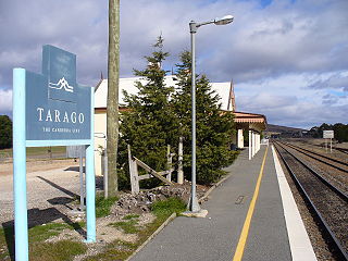
Tarago is a town in the Southern Tablelands of New South Wales, Australia in Goulburn Mulwaree Council. Part of the defined locality, which includes a large area of grazing country, is on the eastern shore of Lake George in the area of the Queanbeyan–Palerang Regional Council. The town is situated 39 kilometres south of the city of Goulburn and 69 kilometres northeast of Canberra, the capital city of Australia. It is located on the Goulburn-Braidwood road. The town is notable for recent renewable energy projects in the surrounding districts.
Alinta wind farm is a wind power station at Walkaway, just south of Geraldton, Western Australia. It is owned by Infigen Energy and has offtake agreements with Alinta Energy and AGL Energy.

Wind power became a significant energy source within South Australia over the first two decades of the 21st century. In 2015, there was an installed capacity of 1,475 MW, which accounted for 34% of electricity production in the state. This accounted for 35% of Australia's installed wind power capacity. In 2021, there was an installed capacity of 2052.95 MW, which accounted for 42.1% of the electricity production in the state in 2020.

Lake Bonney Wind Farm is a wind farm near Millicent, South Australia, Australia. The wind farm is south of, and contiguous with, Canunda Wind Farm. Both are built along the Woakwine Range - a line of stabilised sand dunes that once were coastal.
Lake Bonney SE is a coastal freshwater lake located in the Limestone Coast region of South Australia in the gazetted locality of Canunda. It has a surface area of 79 square kilometres (31 sq mi).
The Capital Wind Farm near Bungendore is the largest wind farm in New South Wales. It is part of the 6,000-hectare (15,000-acre) Capital Renewable Energy Precinct, along with nearby Woodlawn Wind Farm and the Capital East Solar Demonstration Plant.

The Great South Australian Coastal Upwelling System is a seasonal upwelling system in the eastern Great Australian Bight, extending from Ceduna, South Australia, to Portland, Victoria, over a distance of about 800 kilometres (500 mi). Upwelling events occur in the austral summer when seasonal winds blow from the southeast. These winds blow parallel to the shoreline at certain areas of the coast, which forces coastal waters offshore via Ekman transport and draws up cold, nutrient-rich waters from the ocean floor.

Infigen Energy (Infigen), operating under this name since 29 April 2009, is a developer, owner and operator of renewable energy generation assets in Australia. Infigen's wind farm portfolio has an installed capacity of 557 MW. Most of Infigen's assets generate electricity from renewable sources and are eligible to sell Large-scale Generation Certificates (LGCs) under the mandatory Renewable Energy Target scheme, which operates in Australia under the Renewable Energy (Electricity) Act 2000. Since 2020, Infigen Energy has been a subsidiary of Iberdrola.
The Woodlawn Wind Farm is a wind farm located near Bungendore, New South Wales. It is part of the Capital Renewable Energy Precinct, along with nearby Capital Wind Farm and the Woodlawn Bioreactor.

Canunda is a locality in the Australian state of South Australia located on the state’s south-east coast overlooking the body of water known in Australia as the Southern Ocean and by international authorities as the Great Australian Bight. It is about 339 kilometres south-east of the state capital of Adelaide and 49 kilometres south of the centre of Mount Gambier.
The Hundred of Mayurra is a cadastral division of the County of Grey in southeastern South Australia. It was named on 15 July 1869 for an Aboriginal word meaning fern straws.

Corybas carsei, commonly known as the swamp helmet orchid, is a species of terrestrial orchid endemic to New Zealand. It is found only in Whangamarino Wetland in the Waikato District, where the population of fewer than 250 plants is critically endangered.
Woakwine Conservation Park is a protected area located in the Australian state of South Australia in the locality of Robe about 272 kilometres (169 mi) south-east of the state capital of Adelaide and about 8 kilometres (5.0 mi) east of the town centre in Robe.
