Wolf Point, Chicago

Last updated

Wolf Point in July 2018 Wolf Point 2018.jpg
Wolf Point in July 2018
Map depicting Wolf Point (area owned by the Kennedy family in black, with approximate area of the historical Wolf Point settlement in red) Wolf Point map.jpg
Map depicting Wolf Point (area owned by the Kennedy family in black, with approximate area of the historical Wolf Point settlement in red)

Wolf Point is the location at the confluence of the North, South and Main Branches of the Chicago River in the present day Near North Side, Loop, and Near West Side community areas of Chicago. This fork in the river is historically important in the development of early Chicago. Located about 1.6 miles (2.6 km) from Lake Michigan, [1] this was the location of Chicago's first three taverns, its first hotel, Sauganash Hotel, its first ferry, its first drug store, its first church, its first theater company, and the first bridges across the Chicago River. The name is said to possibly derive from a Native American Chief whose name translated to wolf, but alternate theories exist.

Contents

Historically, the west bank of the river at the fork was called "Wolf Point," but in the 1820s and 1830s it came to denote the entire area and the settlement that grew up around the river-fork. Wolf Point is now often used more specifically to refer to a plot of land on the north side of the fork in the Near North Side community area owned by the Kennedy family, now occupied by Wolf Point South Tower. Today the north bank at the fork, is the location of a high-rise and a construction site, the west bank includes condominium high rises, commercial skyscrapers, and railroad tracks, while the south bank includes part of the Chicago Riverwalk and serves as the transition point of Wacker Drive from an east–west street to a north–south street.

Background

View of Wolf Point from the south in the Chicago Loop (2005) Wolf Point from Loop.jpg
View of Wolf Point from the south in the Chicago Loop (2005)

The origin of the name, Wolf Point, is unknown. In her 1856 memoir Wau-Bun, Juliette Kinzie states that 'the place was then called Wolf Point, from its having been the residence of an Indian named "Moa-way," or "the Wolf."' [2] Other alternate explanations are that it was so-named after the landlord of what would later be called the Wolf Point Tavern killed a ferocious wolf and hung a painted sign of a wolf outside his tavern to commemorate the event, [3] or that it was named by a soldier at Fort Dearborn because it was a place where wolves would gather at night. [4] Originally the term Wolf Point referred to the west bank of the Chicago River at the fork junction of its branches, [5] [6] [7] but it gradually came to refer to the whole region around the forks and in modern usage is often more specifically used to mean the plot of land on the north side of the forks. [7] The confluence of the three branches of the river near Wolf Point provided inspiration for Chicago's Municipal Device, a Y-shaped, city identification symbol that can be seen on many buildings in Chicago, and on city owned vehicles. [8] [9]

Early settlement

Wolf Point in 1833 Chicago in 1833 - V.O. Hammon Publishing Co. Chicago (Front) crop.jpg
Wolf Point in 1833
Wolf Point 1830 Andreas.jpg
View of Wolf Point from the south as it might have appeared in 1830 (published in 1884); the Wolf Point Tavern is on the left, the Miller Tavern is on the right
Chicago River from Lake Street bridge.jpg
Wolf Point from a similar viewpoint in 2009; among the buildings and structures shown are (left to right) Left Bank at K Station (300 North Canal), 333 North Canal, Kinzie Street railroad bridge, 350 West Mart Center, Merchandise Mart, 300 North LaSalle, Franklin Street Bridge and part of 333 Wacker Drive

The first non-indigenous settler at Wolf Point may have been a trader named Guarie. Writing in 1880 Gurdon Hubbard, who first arrived in Chicago on October 1, 1818, stated that he had been told of Guarie by Antoine De Champs and Antoine Beson, who had been traversing the Chicago Portage annually since about 1778. [10] Hubbard wrote that De Champs had shown him evidence of a trading house and the remains of a cornfield supposed to have belonged to Guarie. [11] The cornfield was located on the west bank of the North Branch of the Chicago River, a short distance from the forks at what is now Fulton Street; early settlers named the North Branch of the Chicago River the Guarie River, or Gary's River. [11] [12]

James Kinzie, the son of early settler John Kinzie, built a tavern on the west bank of the river at Wolf Point in 1828. [5] [13] By 1829 this tavern was operated for Kinzie by Archibald Caldwell who was granted a liquor license on December 8 of that year. [lower-alpha 1] Caldwell left Chicago early in 1830 and Elijah Wentworth became the landlord of the tavern. He was in turn succeeded by Charles Taylor (1831–1833) and William Walters (1833–1836). [5] The tavern became known as the 'Wolf Point Tavern' or 'Wolf Tavern' and a painted sign of a wolf was hung outside the tavern by approximately 1833. [15]

In about 1829, Samuel Miller and his brother John opened a store on the north bank of the river at the forks. [13] [16] In 1830, they enlarged their store and began to operate it as a tavern in competition with the Wolf Point Tavern. On June 2, 1829 Samuel Miller and Archibald Clybourn had been authorized to operate the first ferry across the Chicago River. Clybourn was the ferry man, crossing the North Branch of the river between Miller's tavern and the Wolf Point Tavern. [17] In 1831 John Miller built a log house near his brother's tavern that he used as a tannery; Chicago's first recorded factory. [16] Samuel Miller sold the tavern and moved away following the death of his wife in 1832. [13]

The Sauganash Hotel was Chicago's first hotel. Sauganash2b.jpg
The Sauganash Hotel was Chicago's first hotel.

Mark Beaubien opened the Eagle Exchange Tavern in a log cabin on the south bank in 1829. [18] In 1831 Beaubien added a frame addition and opened the Sauganash Hotel, Chicago's first hotel. [19] [20] Immediately adjacent to the hotel's public bar was Chicago's first drug store. [21] Beaubien left the Sauganash Hotel in 1834, but the hotel continued in operation until it was destroyed by a fire in 1851. [19] In 1837, the hotel hosted the first Chicago theatre company in a converted dining room. [22] [23] The site of the Sauganash Hotel was redeveloped as the Wigwam in 1860; the site today is at 191 North Wacker and is designated as a Chicago Landmark. [24]

James Kinzie built the Green Tree Tavern at the northeastern corner of Canal and Lake Streets in 1833. [19] The tavern went through a succession of owners and name changes before being moved in 1880 to 33, 35, and 37 Milwaukee Avenue. [5] In 1902 plans were made to preserve the building and move it to Garfield Park, however the hotel collapsed before work could start on this project. [25]

Rev. Jesse Walker started the first church on June 14, 1831, with ten members in a log cabin. [26] In 1838, the congregation floated their log cabin across the Chicago River and rolled it on logs to the corner of Washington and Clark Streets, where it is now the First United Methodist Church Chicago Temple. [27]

Archibald Clybourn's ferry across the North Branch of the river was replaced by a bridge in the winter of 1831 and 1832, and a bridge across the South Branch of the river located between Lake and Randolph Streets [28] was added in the winter of 1832 and 1833. Early settlers J. D. Caton, John Bates, Charles Cleaver, and John Noble wrote in a letter in the fall of 1883 that both of these bridges were constructed of logs; they were about 10 feet (3.0 m) wide, and cleared the river by about 6 feet (1.8 m). [29]

Development

Wolf Point in 1870 Wolf Point in 1870.jpg
Wolf Point in 1870
Bird's-eye view of Wolf Point viewed from the east as it appeared in 1893 Wolf Point 1893.jpg
Bird's-eye view of Wolf Point viewed from the east as it appeared in 1893
Wolf Point looking south 2012 Kayakers at Wolf Point, IL.jpg
Wolf Point looking south 2012

When the Illinois and Michigan Canal opened in 1848, the landmass at Wolf Point was decreased by dredging to accommodate a turning basin for ships. [30] In the autumn of the same year the Galena and Chicago Union Railroad opened Chicago's first railroad depot at Wolf Point, on the southwestern corner of Kinzie and Canal Streets. [31] By 1857 the site of Wolf Point Tavern was being used as a lumber yard; [32] the Fulton Elevator, one of Chicago's earliest grain elevators, was built just to the north of the former tavern in 1852. [33] Several blocks to the west of Wolf Point were destroyed in a large fire on September 15, 1859. [34] The Fulton Elevator survived this, and the Great Chicago Fire of 1871, but was burned down on September 7, 1873. [33] It was rebuilt in the same year, and another grain elevator, the St Paul Elevator, was added immediately to the south of the original in 1879. [35] The Chicago, Milwaukee and St. Paul railway company purchased both elevators in 1889 for $400,000, [lower-alpha 2] [37] but demolished them in 1906. [35] Currently, the site is occupied by the Riverbend Condominiums at 333 North Canal Street. [38] [39]

The property on the north bank of the river at Wolf Point was owned by businessman Marshall Field until it was sold to Democratic Party figure and Kennedy family patriarch Joseph P. Kennedy in 1945 or 1946, depending on the source. [40] [41] Although the Kennedy family sold much of the complex center property to Vornado Realty Trust in 1998 as part of a larger $625 million transaction, [lower-alpha 3] [42] the family retained their interest in the 4 acres (16,000 m2) of Wolf Point land. [43] The area still owned by the Kennedy family is bounded by the Chicago River to the east, west, south and 350 West Mart Center to the north. The Merchandise Mart is located diagonally to the northeast. There have been numerous plans to develop the property dating back to the late 1980s. [44] [45] In 2007, the Kennedys planned to develop the property with three high-rises and skyscrapers to designs by Argentine-American architect César Pelli. [43] In 2012, updated plans were proposed with several target completion dates over the next decade. [46] The property is a coveted real estate location that has had several serious redevelopment plans in the past. [47] [48] [49] In 2014, construction began on the first phase of the planned Wolf Point Towers. [50] A joint venture including the AFL-CIO Building Investment Trust and the Kennedy Family [51] completed the 46-story Wolf Point West tower with union construction labor in 2016. [52] [53] [54] A building permit for construction of Wolf Point East was issued on June 22, 2017 as a 60-story, 698-unit, 660-foot (201.17 m) building and by June 28, a joint venture of the AFL-CIO Building Investment Trust, the Kennedy Family, and Hines [55] began construction on the $380 million project [lower-alpha 4] with a $200 million loan [lower-alpha 5] through a lending group that included Bank of America, Citizens Bank, ING Real Estate Finance, and Ullico. [56] [57] Occupancy is expected in 2019. [58]

The south bank is being redeveloped as part of Mayor Rahm Emanuel's plans to extend the Chicago Riverwalk, which is located on the south bank of the Chicago River and will extend from Lake Michigan to the intersection of North Wacker Drive and Lake Street. Design plans are being finalized as of Spring 2015 with completion targeted by the end of 2016 pending funding. Currently, the plan will include a three-story retail space, a large park, and an iconic bridge linking Wacker to the Riverwalk path. [59] [ needs update ]

See also

Notes

Notes

  1. Some sources state that Archibald Caldwell was the first licensed liquor seller in Chicago; [5] [13] however licenses had previously been issued to Archibald Clybourn and Samuel Miller on May 2, 1829. [14]
  2. equivalent to $13,564,444in 2023 [36]
  3. equivalent to $1.17 billion in 2023 [36]
  4. equivalent to $472 million in 2023 [36]
  5. equivalent to $249 million in 2023 [36]

Related Research Articles

<span class="mw-page-title-main">Chicago River</span> System of rivers and canals running through the city of Chicago

The Chicago River is a system of rivers and canals with a combined length of 156 miles (251 km) that runs through the city of Chicago, including its center. Though not especially long, the river is notable because it is one of the reasons for Chicago's geographic importance: the related Chicago Portage is a link between the Great Lakes and the Mississippi River Basin, and ultimately the Gulf of Mexico.

<span class="mw-page-title-main">Merchandise Mart</span> Commercial building in Chicago, Illinois, USA

The Merchandise Mart is a commercial building located in downtown Chicago, Illinois. When it was opened in 1930, it was the largest building in the world, with 4 million square feet (372,000 m2) of floor space. The Art Deco structure is located at the junction of the Chicago River's branches. The building is a leading retailing and wholesale location, hosting 20,000 visitors and tenants per day in the late 2000s.

<span class="mw-page-title-main">Trump International Hotel and Tower (Chicago)</span> Supertall skyscraper condo-hotel in downtown Chicago, Illinois

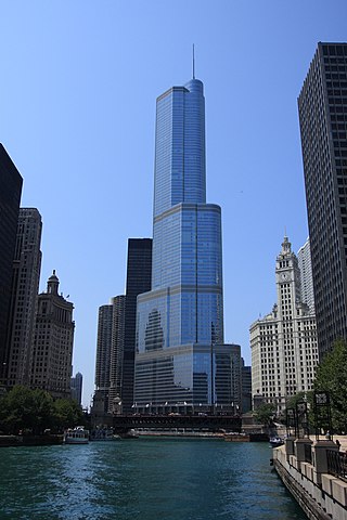
The Trump International Hotel and Tower is a skyscraper condo-hotel in downtown Chicago, Illinois. The building, named for Donald Trump, was designed by architect Adrian Smith of Skidmore, Owings and Merrill. Bovis Lend Lease built the 100-story structure, which reaches a height of 1,388 feet (423.2 m) including its spire, its roof topping out at 1,171 feet (357 m). It is next to the main branch of the Chicago River, with a view of the entry to Lake Michigan beyond a series of bridges over the river. The building received publicity when the winner of the first season of The Apprentice reality television show, Bill Rancic, chose to manage the construction of the tower over managing a Rancho Palos Verdes based "Trump National Golf Course & Resort" in the Los Angeles metro area.

<span class="mw-page-title-main">Near North Side, Chicago</span> Community area in Chicago

The Near North Side is the eighth of Chicago's 77 community areas. It is the northernmost of the three areas that constitute central Chicago, the others being the Loop and the Near South Side. The community area is located north and east of the Chicago River. To its east is Lake Michigan, and its northern boundary is the early 19th-century city limit of Chicago, North Avenue. In 2020 the Near North Side had 105,481 residents, surpassing Lake View as the largest Chicago community area by population. It is also the most densely populated community area and has the second most skyscrapers, after the Loop. With the exception of Goose Island, the Near North Side is known for its extreme affluence, typified by the Gold Coast, Magnificent Mile, Navy Pier, and skyscrapers.

<span class="mw-page-title-main">Lakeshore East</span> Human settlement in Chicago, Illinois

Lakeshore East is a master-planned mixed use urban development being built by the Magellan Development Group in the Loop community area of Chicago in Cook County, Illinois, United States. It is located in the northeastern part of the Loop, which, along with Illinois Center, is called the New Eastside. The development is bordered by Wacker Drive to the north, Columbus Drive to the west, Lake Shore Drive to the east, and East Randolph Street to the south. Skidmore, Owings & Merrill created the master plan for the area. The development, which had been scheduled for completion in 2011, was set for completion in 2013 by 2008. Development continued with revised plans for more buildings in 2018 and continuing construction of the Vista Tower in 2019.

<span class="mw-page-title-main">330 North Wabash</span> Skyscraper in Chicago

330 North Wabash is a skyscraper in downtown Chicago, Illinois, United States, at 330 N. Wabash Avenue, designed by architect Ludwig Mies van der Rohe. A small bust of the architect by sculptor Marino Marini is displayed in the lobby. The 52-story building is situated on a plaza overlooking the Chicago River. At 695 feet, 330 North Wabash is the second-tallest building by Mies van der Rohe, the tallest being the Toronto-Dominion Bank Tower at Toronto-Dominion Centre. It was his last American building.

<span class="mw-page-title-main">Chicago station (CTA Red Line)</span> Chicago "L" station

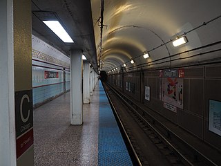
Chicago, is an "L" station on the CTA's Red Line. It serves a significant portion of the Near North Side and Streeterville neighborhoods. With 5,259,992 overall boardings in 2014, it is the busiest station on the Red Line north of the Loop.
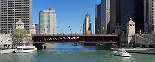
<span class="mw-page-title-main">Block 37</span> Development in Chicago

108 North State Street, also known as Block 37, is a development located in the Loop community area of downtown Chicago, Illinois. It is located on the square block bounded clockwise from the North by West Randolph Street, North State Street, West Washington Street and North Dearborn Street that is known as "Block 37", which was its designated number as one of the original 58 blocks of the city. Above-ground redevelopment is complete, but work stopped on an underground station, when the station was only partially complete.

<span class="mw-page-title-main">Wigwam (Chicago)</span> Convention center in Chicago (demolished)

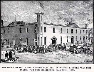
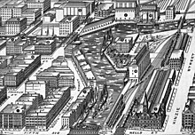
The Wigwam was a convention center and meeting hall that served as the site of the 1860 Republican National Convention. It was located in Chicago, Illinois, at Lake Street and Market near the Chicago River. This site had previously been the site of the Sauganash Hotel, Chicago's first hotel. This is where supporters ushered Abraham Lincoln to the party nomination and the eventual U.S. Presidency. The location at Lake and Wacker was designated a Chicago Landmark on November 6, 2002. The name "Wigwam" was later associated with host locations for both the 1864 Democratic National Convention and the 1892 Democratic National Convention in Chicago.

<span class="mw-page-title-main">Sauganash Hotel</span> First hotel in Chicago

Sauganash Hotel is a former hotel; regarded as the first hotel in Chicago, Illinois. Built in 1831, it was located at Wolf Point in the present day Loop community area at the intersection of the north, south and main branches of the Chicago River. The location at West Lake Street and North Wacker Drive was designated a Chicago Landmark on November 6, 2002. The hotel changed proprietors often in its twenty-year existence and briefly served as Chicago's first theater. It was named after Sauganash, an interpreter in the British Indian Department.

<span class="mw-page-title-main">Rush Street (Chicago)</span> Thoroughfare in Chicago, United States

Rush Street is a one-way street in the Near North Side community area of Chicago in Cook County, Illinois, United States. The street, which starts at the Chicago River between Wabash and North Michigan Avenues, runs directly north until it slants on a diagonal as it crosses Chicago Avenue then it continues to Cedar and State Streets, making it slightly less than a mile long. One lane also runs southbound from Ohio Street (600N) to Kinzie Street (400N) as part of a two-way street segment. It runs parallel to and one block west of the Magnificent Mile on the two-way traffic North Michigan Avenue, which runs at 100 east up to 950 north. The street, which is also one block east of the one-way southbound Wabash Avenue, formerly ran slightly further south to the Chicago River where over time various bridges connected it to the Loop, Chicago's central business district.

<span class="mw-page-title-main">Fulton River District, Chicago</span> Chicago neighborhood

Fulton River District is a Chicago neighborhood located on the edge of Chicago's downtown, northwest of the Loop. The district is bounded by the Chicago River to the east, the Kennedy Expressway to the west, Ohio Street to the north and Madison Street to the south, making it part of the Near West Side and West Town community areas of Chicago in Cook County, Illinois, United States. Just across the expressway to the west is the Fulton Market District. Money magazine ranked the neighborhood as #4 best place to live in the United States in 2019.

<span class="mw-page-title-main">Kinzie Street railroad bridge</span> Bridge in Chicago

The Chicago and North Western Railway's Kinzie Street railroad bridge is a single leaf bascule bridge across the north branch of the Chicago River in downtown Chicago, Illinois. At the time of its opening in 1908 it was the world's longest and heaviest bascule bridge. The previous bridges on the same site included a pedestrian span that was the first bridge across the Chicago River; a second bridge that served as Chicago's first railroad bridge; and a third bridge that was one of the first all-steel spans in the United States.

<span class="mw-page-title-main">Equitable Building (Chicago)</span> Building in Chicago, Illinois USA

401 North Michigan is a 35-story skyscraper in the Streeterville area of Chicago, built in 1965 at 401 North Michigan Avenue, along the north bank of the Chicago River. It was designed by Bruce Graham and Natalie de Blois in the international style. Along with the Tribune Tower and Wrigley Building, it forms the southern gateway to Chicago's famous Magnificent Mile. The building was built atop the site of a cabin belonging to Chicago's first permanent resident, Jean Baptiste Pointe du Sable. In reference to du Sable, the large plaza adjacent to the building has been named Pioneer Court.

<span class="mw-page-title-main">350 North Orleans</span> Building in Chicago

350 North Orleans is the official name of the 24-floor multipurpose building located in the River North community area of Chicago, at the intersection of the North Branch and the Main Branch of the Chicago River. It was designed by Skidmore, Owings & Merrill. In 1988, Helmut Jahn designed an enclosed pedestrian walking bridge over Orleans Street connecting the building to Merchandise Mart. Originally built to serve as the world's largest wholesale buying center for the clothing industry, the building has more commonly known by several other names including River North Point, TheApparel Mart, and the Chicago Apparel Center. The building opened on November 6, 1976.

<span class="mw-page-title-main">Chicago Riverwalk</span> Public space in Chicago, Illinois, USA

The Chicago Riverwalk is a multi-use public open space located on the south bank of the main branch of the Chicago River in Chicago, extending from Lake Michigan and Lake Shore Drive westward to Lake Street. The Chicago Riverwalk contains restaurants, bars, cafes, small parks, boat and kayak rentals, a Vietnam War memorial, and other amenities.

<span class="mw-page-title-main">Salesforce Tower Chicago</span> Skyscraper in Chicago, Illinois, USA

Salesforce Tower Chicago is a skyscraper at Wolf Point in downtown Chicago. It is the tallest and last built of a three tower megadevelopment partly owned by the Kennedy family. The 835 ft (255 m)-tall tower was designed by Pelli Clarke and was completed in 2023. It is the regional headquarters of software company Salesforce.

Wolf Point East Tower is the second tallest of three buildings being developed in the Near North Side community area on the Wolf Point property at a fork in the Chicago River in downtown Chicago. The building is planned to be approximately 60 stories and 660 feet (201.2 m) tall. It will have 698 units. Although originally intended to be a mixed use building when planned in 2012 and approved in 2013, the building was reenvisioned as an apartment building in 2016. Construction began in 2017 and is currently finished.

References

  1. "Chicago River System Map - About the River". www.chicagoriver.org. Retrieved April 28, 2021.
  2. Kinzie 1856 , p. 182
  3. Andreas 1884 , pp. 629–630
  4. Hurlbut 1881 , p. 498
  5. 1 2 3 4 5 "Chicago at a Glance—Seventeenth and Eighteenth Wards". Chicago Daily Tribune. June 17, 1900.
  6. Hill 2000 , p. 31
  7. 1 2 Solzman 2006 , p. 101
  8. "The Municipal Device". Forgotten Chicago. Retrieved November 21, 2010.
  9. "The Chicago Municipal Device (Y-Shaped Figure)". Chicago Public Library. Archived from the original on September 3, 2006. Retrieved June 20, 2007.
  10. Blanchard 1881 , pp. 757–759
  11. 1 2 Quaife 1913 , p. 138
  12. Keating, William H. (1824). Narrative of an expedition to the source of St. Peter's river, Lake Winnepeek, Lake of the Woods, &c., performed in the year 1823 (volume 1). H. C. Carey & I. Lea. p.  172 . Retrieved October 30, 2010.
  13. 1 2 3 4 Andreas 1884 , p. 629
  14. East, Ernest E (September 1938). "Contributions to Chicago History from Peoria County Records (part 2)". Journal of the Illinois State Historical Society. 31 (3): 323–343. JSTOR   40187536.
  15. Andreas 1884 , p. 631
  16. 1 2 "Chicago at a Glance—Twenty-first, Twenty-second, and Twenty-third Wards". Chicago Daily Tribune. June 17, 1900.
  17. Hurlbut 1881 , p. 505
  18. Currey 1912 , pp. 100–102
  19. 1 2 3 Andreas 1884 , pp. 632–633
  20. Berger, Molly W. (2005). "Hotels". Encyclopedia of Chicago . Chicago Historical Society . Retrieved July 15, 2010.
  21. Bulletin of pharmacy. Vol. 16. Nabu Press. 2010. p. 100. ISBN   978-1-144-46348-7 . Retrieved September 24, 2010.
  22. Adler, Tony (2004). Grossman, James R.; Keating, Ann Durkin; Reiff, Janice L. (eds.). Theater. The University of Chicago Press. pp. 815–6. ISBN   0-226-31015-9 . Retrieved July 18, 2010.{{cite book}}: |work= ignored (help)
  23. Lewis, Charlton Thomas; Joseph H. Willsey, eds. (1895). Harper's book of facts: a classified history of the world; embracing science. Harper & Brothers. p.  163 . Retrieved September 25, 2010. Sauganash Hotel.
  24. "Site of the Sauganash Hotel/Wigwam". City of Chicago Department of Planning and Development, Landmarks Division. Retrieved July 15, 2010.
  25. "Green Tree Tavern Falls: Two Men Hurt in Collapse". Chicago Tribune. August 5, 1902.
  26. Cutler, I. (1973). Chicago. SIU Press. p. 404. ISBN   9780809387953 . Retrieved March 8, 2015.
  27. "Chicago Temple – United Methodist Church » History". chicagotemple.org. Retrieved March 8, 2015.
  28. Andreas 1884 , p. 133
  29. Andreas 1884 , p. 632
  30. Hill 2000 , pp. 90–91
  31. Grant, H. Roger (1996). The Northwestern: A History of the Chicago & Northwestern Railway System. Northern Illinois University Press. p. 21. ISBN   0-87580-214-1.
  32. Hurlbut 1881 , p. 499
  33. 1 2 "The Elevator Fire". Chicago Daily Tribune. September 8, 1873. - Clipping at Newspapers.com.
  34. "Great Fire in the West Division". Chicago Daily Tribune. September 16, 1859. - Clipping at Newspapers.com.
  35. 1 2 "Build on Elevator Site". Chicago Daily Tribune. July 19, 1906.
  36. 1 2 3 4 1634–1699: McCusker, J. J. (1997). How Much Is That in Real Money? A Historical Price Index for Use as a Deflator of Money Values in the Economy of the United States: Addenda et Corrigenda (PDF). American Antiquarian Society. 1700–1799: McCusker, J. J. (1992). How Much Is That in Real Money? A Historical Price Index for Use as a Deflator of Money Values in the Economy of the United States (PDF). American Antiquarian Society. 1800–present: Federal Reserve Bank of Minneapolis. "Consumer Price Index (estimate) 1800–" . Retrieved February 29, 2024.
  37. "Big Deal in Elevators". Chicago Daily Tribune. February 25, 1899. - Clipping at Newspapers.com.
  38. "Riverbend Condominiums". glasssteelandstone.com. Retrieved November 20, 2010.
  39. "Riverbend Condominiums". Emporis.com . Retrieved November 20, 2010.[ dead link ]
  40. Giovannini, Joseph (June 16, 1998). "New Pieces, New Looks For the Office". The New York Times . Retrieved July 13, 2010.
  41. Feuerstein, Phyllis (August 22, 1993). "Christopher Kennedy Chicago's The Place To Work On The Other Family Business". Chicago Tribune. pp. 8, 10. - Clipping of first and of second page at Newspapers.com.
  42. "Kennedy Family Selling Merchandise Mart To Vornado Realty". Chicago Tribune . January 26, 1998. p. 3.
  43. 1 2 Gallun, Alby (June 30, 2007). "Kennedys, developer plan big Wolf Point project". ChicagoBusiness . Crain Communications, Inc. Retrieved July 14, 2010.
  44. Davis, Jerry C. (September 3, 1989). "Wolf Point, part of Mart face redevelopment". Chicago Sun-Times .
  45. "Wolf Point". Emporis.com . Retrieved July 14, 2010.[ dead link ]
  46. Kamen, Blair (June 3, 2012). "Wolf Point". Chicago Tribune .
  47. "Wolf Point". Emporis.com . Retrieved September 17, 2010.[ dead link ]
  48. "Wolf Point". Emporis.com . Retrieved September 17, 2010.[ dead link ]
  49. "Wolf Point Apartments". Emporis.com . Retrieved September 17, 2010.[ dead link ]
  50. "Construction Begins on Wolf Point West: Luxury rental units, office, retail space and possibly a hotel planned for development". WMAQ-TV. July 18, 2014. Retrieved September 18, 2014.
  51. Janssen, Kim. "Chris Kennedy takes swipe at 'state leaders,' won't discuss governor's race". chicagotribune.com. Retrieved February 14, 2018.
  52. "Ribbon cut to officially open first Wolf Point tower". Loop North News. Retrieved February 14, 2018.
  53. Gallun, Alby (March 8, 2017). "Kennedys seek buyer for Wolf Point apartment tower". Crain's Chicago Business . Retrieved March 15, 2017.
  54. ctbuh. "Groundbreaking Ceremony Held for Chicago's Wolf Point West Tower". ctbuh. Retrieved February 14, 2018.
  55. "60-story Wolf Point East apartment tower cleared to rise". Curbed Chicago. Retrieved February 14, 2018.
  56. Koziarz, Jay (June 22, 2017). "Second Wolf Point apartment tower cleared to rise along the Chicago River". Curbed Chicago. Retrieved July 6, 2017.
  57. Gallun, Alby (June 28, 2017). "Wolf Point developers land $200 million loan for 60-story tower". Crain's Chicago Business . Retrieved July 6, 2017.
  58. Baiceanu, Roxana (July 4, 2017). "Construction Kicks Off at Chicago's Wolf Point East". Multi-Housing News . Retrieved July 6, 2017.
  59. "Chicago Riverwalk". City of Chicago. Retrieved April 17, 2015.

Bibliography

41°53′10″N87°38′17″W / 41.88611°N 87.63806°W / 41.88611; -87.63806