
In geology, a fjord or fiord is a long, narrow inlet with steep sides or cliffs, created by a glacier. There are many fjords on the coasts of Alaska, Antarctica, British Columbia, Chile, Denmark, Greenland, the Faroe Islands, Iceland, Ireland, Kamchatka, the Kerguelen Islands, New Zealand, Norway, Novaya Zemlya, Labrador, Nunavut, Newfoundland, Quebec, Scotland, South Georgia Island, Isla de los Estados, and Washington state. Norway's coastline is estimated at 29,000 kilometres (18,000 mi) with nearly 1,200 fjords, but only 2,500 kilometres (1,600 mi) when fjords are excluded.

The Back River, formerly Back's River, is the 20th longest Canadian river and is located in the Northwest Territories and Nunavut. It rises at an unnamed lake in the North Slave Region of the Northwest Territories and flows more than 974 km (605 mi) mostly through the Kivalliq Region, Nunavut, to its mouth at the Arctic Ocean in the Kitikmeot Region of Nunavut.

Ukkusiksalik National Park is a national park in Nunavut, Canada. It covers 20,885 km2 (8,064 sq mi) of tundra and coastal mudflats south of the Arctic Circle and the hamlet of Naujaat, from Hudson Bay's Roes Welcome Sound towards the western Barrenlands and the source of Brown River. The park surrounds Wager Bay, a 100 km (62 mi)-long inlet on the Hudson Bay. Although the smallest of Nunavut's four national parks, it is the sixth largest in Canada. Its name relates to steatite found there: Ukkusiksalik means "where there is material for the stone pot".

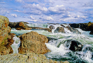
The Coppermine River is a river in the North Slave and Kitikmeot regions of the Northwest Territories and Nunavut in Canada. It is 845 kilometres (525 mi) long. It rises in Lac de Gras, a small lake near Great Slave Lake, and flows generally north to Coronation Gulf, an arm of the Arctic Ocean. The river freezes in winter but may still flow under the ice.

Coronation Gulf lies between Victoria Island and mainland Nunavut in Canada. To the northwest it connects with Dolphin and Union Strait and thence the Beaufort Sea and Arctic Ocean; to the northeast it connects with Dease Strait and thence Queen Maud Gulf.
The Kazan River, is a Canadian Heritage River located in Nunavut, Canada. The Dene name for the river was Kasba-tue meaning "white partridge river." The name was apparently changed to Kazan in the late 19th century due to the influence of Order of Mary Immaculate missionaries. The river headwaters are in northern Saskatchewan at Kasba Lake, and it flows north for about 1000 km (621 mi) before emptying into Baker Lake, on the opposite side of the mouth of the Thelon River. Along its course the river flows through several lakes, including Ennadai Lake and Yathkyed Lake, over the Kazan Falls, down a red sandstone gorge and through both boreal forest and tundra. It is the last section of the river, below Ennadai Lake, that is above the timber line and is designated a Canadian Heritage River.

The Soper River is a waterway on Baffin Island, Nunavut. The river flows over 100 km (62 mi) and then empties into Soper Lake and Pleasant Inlet. The Soper River was designated a Canadian Heritage River in 1992.
The Burnside River is a river in the Canadian territory of Nunavut. It has its headwaters at Contwoyto Lake, flows across the Precambrian Shield's Contwoyto Plateau, flows through isolated and rugged tundra, into Lake Kathawachaga, and through the Wilberforce Hills region. Before emptying into Bathurst Inlet on the Arctic Ocean, the Mara River empties into the Burnside River. The river has an island, Nadlak, historically notable for Inuit use of caribou antlers as hut roof infrastructures.

The Tree River (Kogluktualuk) is a river in Nunavut, Canada. It flows into Coronation Gulf, an arm of the Arctic Ocean.

The Arctic Cordillera is a terrestrial ecozone in northern Canada characterized by a vast, deeply dissected chain of mountain ranges extending along the northeastern flank of the Canadian Arctic Archipelago from Ellesmere Island to the northeasternmost part of the Labrador Peninsula in northern Labrador and northern Quebec, Canada. It spans most of the eastern coast of Nunavut with high glaciated peaks rising through ice fields and some of Canada's largest ice caps, including the Penny Ice Cap on Baffin Island. It is bounded to the east by Baffin Bay, Davis Strait and the Labrador Sea while its northern portion is bounded by the Arctic Ocean.

The Koukdjuak River begins at the outlet of Nettilling Lake and empties into the Arctic Ocean. It is the namesake of the Great Plain of the Koukdjuak located in the Foxe Basin on western Baffin Island, Nunavut, northern Canada.

Copper Inuit also known as Kitlinermiut) and Inuinnait are a Canadian Inuit group who live north of the tree line, in what is now Nunavut's Kitikmeot Region and the Northwest Territories's Inuvik Region. Most historically lived in the area around Coronation Gulf, on Victoria Island, and southern Banks Island.
The Rae River (Pallirk) is a waterway that flows from Akuliakattak Lake into Richardson Bay, Coronation Gulf. Its mouth is situated northwest of Kugluktuk, Nunavut. Its shores were the ancestral home of Copper Inuit subgroups: the Kanianermiut and the Pallirmiut.
The Hoppner River flows northward from Wollaston Peninsula into Dolphin and Union Strait at the juncture with the Amundsen Gulf in Nunavut, Canada. Long-tailed duck frequent the area.

Hornaday River is a waterway located above the Arctic Circle on the mainland of Northern Canada.
The Asiak River is a waterway in the Kitikmeot Region of Nunavut in Canada. It flows generally north to Coronation Gulf, an arm of the Arctic Ocean. It runs parallel to the Coppermine River, 29 kilometres (18 mi) to the west.
The Napaaktoktok River is a waterway in the Kitikmeot region of Nunavut in Canada. It flows generally north to Coronation Gulf, an arm of the Arctic Ocean. The Napaaktoktok runs parallel to the Coppermine River, 14.4 km (8.9 mi) to the west, and the Asiak River, 15.2 km (9.4 mi) to the east.
Kangiqtualuk Uqquqti formerly Sam Ford Fiord is an isolated, elongated Arctic fjord on Baffin Island's northeastern coast in the Qikiqtaaluk Region of Nunavut, Canada. The Inuit settlement of Pond Inlet is 320 km (200 mi) to the northwest and Clyde River is 80 km (50 mi) to the east.
Arviqtujuq Kangiqtua formerly Eglinton Fiord is a fjord on Baffin Island's northeastern coast in the Qikiqtaaluk Region of Nunavut, Canada. The Inuit settlement of Pond Inlet is 355 km (221 mi) to the northwest and Clyde River is 55 km (34 mi) to the east.
