
Waterfall is a small suburb in southern Sydney, in the state of New South Wales, Australia. It is 40 kilometres south of the Sydney central business district in the Sutherland Shire. It is the southernmost suburb of Sydney in the eastern corridor, on the Princes Highway, bordering the Illawarra region.

Lucas Heights is a suburb in southern Sydney, in the state of New South Wales, Australia. It is near to the Royal National Park.

The Wingecarribee River, a perennial river that is part of the Hawkesbury–Nepean catchment, is located in the Southern Highlands region of New South Wales, Australia.

Sutherland Shire is a local government area in the southern region of Sydney, in the state of New South Wales, Australia. The Sutherland Shire is located just south of the Sydney CBD, and comprises an area of 370 square kilometres (140 sq mi) and as at the 2016 census and has an estimated population of 218,464. The Sutherland Shire is colloquially known as "The Shire" which has been featured in several reality television series.

Illawong is a suburb in southern Sydney, in the state of New South Wales, Australia. Illawong is located 27 kilometres south of the Sydney Central Business District, in the local government area of the Sutherland Shire in the area commonly called Menai. The post code is 2234, which is also assigned to the contiguous suburbs of Menai, Bangor Barden Ridge and Alfords Point.
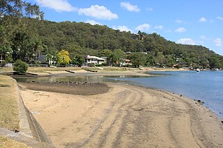
Woronora is a suburb in southern Sydney, in the state of New South Wales, Australia. Woronora is located 27 kilometres south of the Sydney central business district, in the local government area of the Sutherland Shire. Woronora Heights is a separate suburb, to the south-west.

Woronora Heights is a suburb in southern Sydney, in the state of New South Wales, Australia. Woronora Heights is located 29 kilometres south of the Sydney central business district, in the local government area of the Sutherland Shire. Woronora is a separate suburb, to the north. Most streets in Woronora Heights are named after birds.

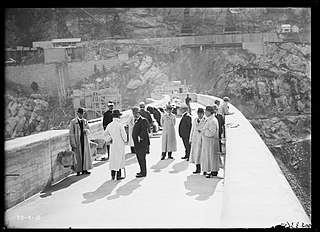
The Woronora Dam is a heritage-listed concrete gravity dam with an uncontrolled serpentine spillway across the Woronora River, located south of Greater Metropolitan Sydney, in the suburb of Woronora Dam, Sutherland Shire, New South Wales, Australia. The principal purpose of the dam is for potable water supply for Sydney's southern suburbs and the northern suburbs of the Illawarra region. The impounded 71,790-megalitre reservoir is also called Woronora Dam and is sometimes incorrectly called Lake Woronora. The dam was designed by G. E. Haskins, Chief Engineer and the Metropolitan Water, Sewerage and Drainage Board of NSW (MWS&DB) and built from 1927 to 1941 by the MWS&DB. The property is owned by the Sydney Catchment Authority, an agency of the Government of New South Wales. It was added to the New South Wales State Heritage Register on 18 November 1999.
Como West is a locality in southern Sydney, in the state of New South Wales, Australia. It is located in the western part of the suburb of Como. The postcode is 2226, the same as Como.

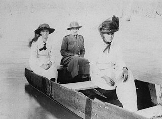
The Woronora River is a perennial river of the Sydney Basin, located in the Sutherland Shire local government area of Greater Metropolitan Sydney, approximately 22 kilometres (14 mi) south of the Sydney central business district, in New South Wales, Australia.
Bayonet Head is an outer north-eastern suburb of Albany, Western Australia, on the west bank of Oyster Harbour. Its local government area is the City of Albany. Until the 1980s, it was known as Flinders Park.
Balmoral is a Northern Village of the Southern Highlands area of New South Wales, Australia. It is the northernmost village in Wingecarribee Shire.
Burrinjuck is a village community in the far eastern part of the Riverina, in the South West Slopes. It is situated by road, about 15 kilometres (9.3 mi) southwest from Woolgarlo and 28 kilometres (17 mi) south from Bookham. The name of the town is derived from an Aboriginal word meaning 'mountain with a rugged top'. At the 2016 census, the Burrinjuck area had a population of 19.
Upper Kangaroo River is a small village in the Southern Highlands of New South Wales, Australia, in Shoalhaven City Council. It is located on the Kangaroo River, a tributary of the Shoalhaven River. At the 2021 census, it had a population of 151.

The Cordeaux River, a perennial river of the Hawkesbury-Nepean catchment, is located in the Southern Highlands and Macarthur regions of New South Wales, Australia.

Russell Vale is a small suburb of Wollongong in the Illawarra region of New South Wales, Australia.
Avon is a suburb of the City of Wollongong and Wingecarribee Shire, both in New South Wales, Australia. It is "a locality within Metropolitan Catchment Area on the western side of Illawarra Range about 4km west of Wongawilli and about 5km north west of Avondale". At the 2016 census, it had no population.
Cordeaux is a suburb of the City of Wollongong, New South Wales, Australia.
Glen Niven is a rural locality in the Southern Downs Region, Queensland, Australia. It is within the Granite Belt on the Darling Downs and adjacent to the border with New South Wales. In the 2021 census, Glen Niven had a population of 99 people.

Cania is a locality in the North Burnett Region, Queensland, Australia. In the 2021 census, Cania had a population of 27 people.
