
Perth is the capital city of Western Australia. It is the fourth most populous city in Australia, with a population of over 2.3 million within Greater Perth as of 2023. It is part of the South West Land Division of Western Australia, with most of Perth's metropolitan area on the Swan Coastal Plain between the Indian Ocean and the Darling Scarp. The city has expanded outward from the original British settlements on the Swan River, upon which its central business district and port of Fremantle are situated.

The Darling Scarp, also referred to as the Darling Range or Darling Ranges, is a low escarpment running north–south to the east of the Swan Coastal Plain and Perth, Western Australia. The escarpment extends generally north of Bindoon, to the south of Pemberton. The adjacent Darling Plateau goes easterly to include Mount Bakewell near York and Mount Saddleback near Boddington. It was named after the Governor of New South Wales, Lieutenant-General Ralph Darling.

Armadale is a suburb of Perth within the City of Armadale, located on the south-eastern edge of the Perth metropolitan region. The major junction of the South Western and Albany Highways, which connect Perth with the South West and Great Southern regions of Western Australia respectively, is located within the suburb. It is also the terminus of the Armadale railway line, one of five major railway lines to service Perth.

Pinjarra is a town in the Peel region of Western Australia along the South Western Highway, 82 kilometres (51 mi) from the state capital, Perth and 21 kilometres (13 mi) south-east of the coastal city of Mandurah. Its local government area is the Shire of Murray. At the 2016 census, Pinjarra had a population of 4910.

Bedfordale is a semi-rural suburb in the south-east of Perth, Western Australia, located within the City of Armadale. Located approximately 40 km from Perth in the Darling Range, some of the local attractions include Churchman Brook Dam, Wungong Dam and the Elizabethan Pub. The area is popular for hiking and cycling. Being close to Armadale railway station provides easy access to the city by train.

Wungong, pronounced is a semi-rural south-eastern suburb of Perth, Western Australia, located midway between Armadale and Byford and located in the local government area of the City of Armadale.

Mount Richon is a suburb of Perth, Western Australia in the City of Armadale. Formerly part of Armadale and Wungong, Mount Richon was approved as a suburb in 2003. It occupies the western slope of the Darling Range from the intersection of Albany and South Western Highways south to Leys Rise, is bounded on the west by South-Western Highway and is bounded on the east by Albany Highway and Bungendore Park. Mount Richon is named after a vineyard that formerly existed in the area.

Armadale is a Legislative Assembly electorate in the state of Western Australia. The district is named for the southeastern Perth suburb of Armadale, which falls within its borders.

The City of Armadale is a local government area in the southeastern suburbs of the Western Australian capital city of Perth, about 28 kilometres (17.4 mi) southeast of Perth's central business district. The City covers an area of 560 square kilometres (216 sq mi), much of which is state forest rising into the Darling Scarp to the east, and had a population of almost 80,000 as at the 2016 Census. At the 2021 census, the population had risen to 94,184.

Beeliar Regional Park is a conservation park approximately 19 kilometres (12 mi) south of the central business district in Perth, Western Australia, located within the Citys of Cockburn, Kwinana and Melville. The regional park is named after the indigenous Beeliar people of the area.
Hilbert is a suburb of Perth, Western Australia, located within the City of Armadale. This rural and semi-rural suburb is located on the city's fringe, and in the 2010s began to be subdivided for urban purposes.

Nandi is a rural locality in the Western Downs Region, Queensland, Australia. In the 2021 census, Nandi had a population of 105 people.

Rockingham Lakes Regional Park is a conservation park approximately 40 kilometres (25 mi) south of Perth, Western Australia, located within the City of Rockingham. The park, established in 1997, covers a non-continuous area of 4,270 hectares and occupies approximately 16 percent of the area of the City of Rockingham.

Jandakot Regional Park is a conservation park approximately 20 kilometres (12 mi) south of Perth, Western Australia, located within the Cities of Armadale, Canning, Cockburn, Gosnells and Kwinana as well as the Shire of Serpentine-Jarrahdale. The park, established in 1997 as the Jandakot Botanic Park, covers a non-continuous area of 2,362 hectares and is managed by the Cities of Armadale, Cockburn and Kwinana. It stretches from the southern end of Jandakot Airport to south of Casuarina Prison.
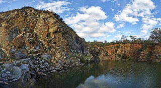
Banyowla Regional Park, formerly Kelmscott-Martin Regional Park, is a conservation park in the Perth Hills, 20 kilometres south-east of Perth, Western Australia, located within the Cities of Gosnells and Armadale. The regional park was re-named in 2008 after Banyowla, who was a Noongar elder at the time of European settlement.
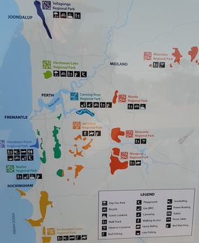
Regional parks in Western Australia are conservation areas with the purpose of serving as urban havens to preserve and restore cultural heritage and valuable ecosystems as well as to encourage sustainable nature-based recreation activities.

Wooroloo Regional Park, formerly Chidlow Regional Park, is a conservation park near Chidlow in the Perth Hills, 40 kilometres north-east of Perth, Western Australia, located within the Shire of Mundaring.

The Spectacles Wetlands is a wetland located in the eponymous suburb, 30 kilometres (19 mi) south of the central business district of Perth, the capital of Western Australia. It is part of Beeliar Regional Park.
Midgegooroo National Park, formerly the Canning National Park, is a national park in the Perth metropolitan region of Western Australia, 43 km (27 mi) south-east of Perth. It is located in the City of Armadale, and part of the Jarrah Forest bioregion.

