Banyowla Regional Park

Last updated

Banyowla Regional Park
Western Australia
Old Barrington Quarry, December 2020.jpg
Old Barrington Quarry, near Ellis Brook Valley
Banyowla Regional Park
Nearest town or city City of Gosnells
Coordinates 32°03′15″S116°02′27″E / 32.05417°S 116.04083°E / -32.05417; 116.04083 (Banyowla Regional Park)
Area2,607 ha (6,440 acres)
Managing authorities Department of Biodiversity, Conservation and Attractions
Website Banyowla Regional Park

Banyowla Regional Park, formerly Kelmscott-Martin Regional Park, is a conservation park in the Perth Hills, 20 kilometres south-east of Perth, Western Australia, located within the Cities of Gosnells and Armadale. The regional park was re-named in 2008 after Banyowla, who was a Noongar elder at the time of European settlement.

Contents

Banyowla is one of eleven regional parks in the Perth region of Western Australia. The purpose of these regional parks is to serve as urban havens to preserve and restore cultural heritage and valuable ecosystems as well as to encourage sustainable nature-based recreation activities. [1]

History

The concept of regional spaces in Western Australia open to the public was first proposed in 1955, when the Stephenson-Hepburn Report recommended preserving private land for future public use in what would become the Perth Metropolitan Region in 1963. The Environmental Protection Authority (EPA) identified areas of significant conservation, landscape and recreation value in a report in 1983. In 1989, the state Government allocated the responsibility of managing regional parks to the Department of Conservation and Land Management. [2]

A Regional Parks Taskforce was established in 1990 but the EPA reported in 1993 that the establishment of these parks encountered difficulties. [2]

In August 2008, Minister for the Environment and Climate Change, David Templeman, announced that our regional parks and three national parks in the Perth Hills would be renamed to Aboriginal names, one of them being Kelmscott-Martin Regional Park, which became Banyowla Regional Park. [3] These four regional parks had, prior to 2008, been part of the larger Darling Range Regional Park which had been formed in the 1990s. [4]

Cultural heritage

Both Banyowla, after whom the park is now named, and Captain Theophilus Tighe Ellis, whom the Ellis Brook Valley is named for, were involved in the 1834 Pinjarra massacre, the former as a victim and the latter as a perpetrator. Ellis, Superintendent of Mounted Police at the time, a short while later died from injuries sustained during the massacre. [5] [6] [7]

Areas

The main areas of the park: [7]

ImageNameSuburbDescriptionCo-ordinates
Ellis Brook Valley, August 2021 07.jpg Ellis Brook Valley Martin 32°03′58″S116°02′26″E / 32.066216°S 116.040613°E / -32.066216; 116.040613 (Ellis Brook Valley)
Hardinge Park Orange Grove 32°01′46″S116°02′06″E / 32.029506°S 116.035115°E / -32.029506; 116.035115 (Hardinge Park)
Hillside Farm Martin 32°03′17″S116°01′30″E / 32.054725°S 116.025108°E / -32.054725; 116.025108 (Hillside Farm)
Lloyd Hughes Park Kelmscott 32°07′04″S116°01′39″E / 32.117678°S 116.027393°E / -32.117678; 116.027393 (Lloyd Hughes Park)

Related Research Articles

<span class="mw-page-title-main">Perth</span> Capital city of Western Australia

Perth is the capital city of Western Australia. It is the fourth most populous city in Australia, with a population of over 2.3 million within Greater Perth as of 2023. It is part of the South West Land Division of Western Australia, with most of Perth's metropolitan area on the Swan Coastal Plain between the Indian Ocean and the Darling Scarp. The city has expanded outward from the original British settlements on the Swan River, upon which its central business district and port of Fremantle are situated.

<span class="mw-page-title-main">Darling Scarp</span> Scarp east of Perth, Western Australia

The Darling Scarp, also referred to as the Darling Range or Darling Ranges, is a low escarpment running north–south to the east of the Swan Coastal Plain and Perth, Western Australia. The escarpment extends generally north of Bindoon, to the south of Pemberton. The adjacent Darling Plateau goes easterly to include Mount Bakewell near York and Mount Saddleback near Boddington. It was named after the Governor of New South Wales, Lieutenant-General Ralph Darling.

<span class="mw-page-title-main">Armadale, Western Australia</span> Suburb of Perth, Western Australia

Armadale is a suburb of Perth within the City of Armadale, located on the south-eastern edge of the Perth metropolitan region. The major junction of the South Western and Albany Highways, which connect Perth with the South West and Great Southern regions of Western Australia respectively, is located within the suburb. It is also the terminus of the Armadale railway line, one of five major railway lines to service Perth.

<span class="mw-page-title-main">Roleystone, Western Australia</span> Suburb of Perth, Western Australia

Roleystone is a suburb of Perth, Western Australia in the south eastern corridor.

<span class="mw-page-title-main">Byford, Western Australia</span> Suburb of Perth, Western Australia

Byford is a suburb on the south-eastern edge of Perth, Western Australia, within the Shire of Serpentine-Jarrahdale. The town has its origins in a township that was gazetted under the name "Beenup" in 1906. In 1920, the name of the township was changed to Byford.

<span class="mw-page-title-main">Kelmscott, Western Australia</span> Suburb of Perth, Western Australia

Kelmscott is a southeastern suburb of Perth, Western Australian within the local government area of the City of Armadale. It is 23 kilometres (14 mi) southeast of Perth along the Albany Highway.

<span class="mw-page-title-main">Whadjuk</span> Noongar people of the Swan Coastal Plain in Western Australia

Whadjuk, alternatively Witjari, are Noongar people of the Western Australian region of the Perth bioregion of the Swan Coastal Plain.

<span class="mw-page-title-main">Whiteman Park</span> Bushland reserve north of Perth, Western Australia

Whiteman Park is a 4,000-hectare bushland area located 22 km (14 mi) north of Perth, Western Australia. The park is in the suburb of Whiteman, in the Swan Valley in the upper reaches of the Swan River.

<span class="mw-page-title-main">Pinjarra massacre</span> Massacre in Pinjarra, Western Australia

The Pinjarra massacre, also known as the Battle of Pinjarra, occurred on 28 October 1834 in Pinjarra, Western Australia when a group of Binjareb Noongar people were attacked by a detachment of 25 soldiers, police, and settlers led by Governor James Stirling. According to Stirling, "about 60 or 70" of the Binjareb people were present at the camp and John Roe, who also participated, estimated about 70–80. This roughly agrees with an estimate of 70 by an unidentified eyewitness. The attack at Pinjarra was in response to sustained aggression by the Binjarebs, including robberies and murder of settlers and members of other Nyungar tribes.

<span class="mw-page-title-main">City of Rockingham</span> Local government area in Western Australia

The City of Rockingham is a council and local government area, comprising the south coastal suburbs of the Western Australian capital city of Perth.

<span class="mw-page-title-main">Flinders Peak Group</span> Unnamed range of hills in the country of Australia

The Flinders Peak Group is an unnamed range of hills located on the northern edge of the Scenic Rim Region, south west of Logan City and south east of the City of Ipswich in South East Queensland, Australia. The summit in the Range is Flinders Peak reaching 680 metres (2,230 ft) above sea level.

<span class="mw-page-title-main">Beeliar Regional Park</span> Regional park in Perth, Western Australia

Beeliar Regional Park is a conservation park approximately 19 kilometres (12 mi) south of the central business district in Perth, Western Australia, located within the Citys of Cockburn, Kwinana and Melville. The regional park is named after the indigenous Beeliar people of the area.

<span class="mw-page-title-main">Rockingham Lakes Regional Park</span>

Rockingham Lakes Regional Park is a conservation park approximately 40 kilometres (25 mi) south of Perth, Western Australia, located within the City of Rockingham. The park, established in 1997, covers a non-continuous area of 4,270 hectares and occupies approximately 16 percent of the area of the City of Rockingham.

<span class="mw-page-title-main">Jandakot Regional Park</span> Regional park in Perth, Western Australia

Jandakot Regional Park is a conservation park approximately 20 kilometres (12 mi) south of Perth, Western Australia, located within the Cities of Armadale, Canning, Cockburn, Gosnells and Kwinana as well as the Shire of Serpentine-Jarrahdale. The park, established in 1997 as the Jandakot Botanic Park, covers a non-continuous area of 2,362 hectares and is managed by the Cities of Armadale, Cockburn and Kwinana. It stretches from the southern end of Jandakot Airport to south of Casuarina Prison.

<span class="mw-page-title-main">Regional parks in Western Australia</span>

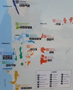
Regional parks in Western Australia are conservation areas with the purpose of serving as urban havens to preserve and restore cultural heritage and valuable ecosystems as well as to encourage sustainable nature-based recreation activities.

<span class="mw-page-title-main">Wooroloo Regional Park</span> Conservation area in Western Australia

Wooroloo Regional Park, formerly Chidlow Regional Park, is a conservation park near Chidlow in the Perth Hills, 40 kilometres north-east of Perth, Western Australia, located within the Shire of Mundaring.

<span class="mw-page-title-main">Wungong Regional Park</span> Regional park in Perth, Western Australia

Wungong Regional Park is a conservation park near Bedfordale in the Perth Hills, 20 kilometres south-east of Perth, Western Australia, located within the City of Armadale.

<span class="mw-page-title-main">Yangebup Lake</span> Lake in Perth, Western Australia

Yangebup Lake is a freshwater lake in the suburb of Yangebup, 18 kilometres (11 mi) south-west of the central business district of Perth, the capital of Western Australia. It is part of Beeliar Regional Park.

Midgegooroo National Park, formerly the Canning National Park, is a national park in the Perth metropolitan region of Western Australia, 43 km (27 mi) south-east of Perth. It is located in the City of Armadale, and part of the Jarrah Forest bioregion.

Theophilus Tighe Ellis was a British colonial administrator who became the first person to become a police officer in Western Australia, and its first police officer to be killed in the line of duty. He was speared by an Aboriginal while participating in the Pinjara massacre.

References

  1. "National, marine and regional parks in Western Australia" (PDF). Department of Parks and Wildlife. June 2017. Archived from the original (PDF) on 2 June 2021. Retrieved 28 May 2021.
  2. 1 2 Rockingham Lakes Regional Park Management Plan 2010 (PDF) (Report). Conservation Commission of Western Australia, Department of Environment and Conservation & City of Rockingham. 2010. Retrieved 28 May 2021.
  3. "New names for hills parks reflect Aboriginal heritage". Government of Western Australia. 7 August 2008. Archived from the original on 31 January 2019. Retrieved 29 May 2021.
  4. "Perth Hills bushfire February 2011 review" (PDF). Government of Western Australia. 15 April 2011. Retrieved 29 May 2021.
  5. "About Ellis Brook Valley" (PDF). bushlandperth.org.au. Retrieved 29 May 2021.
  6. "Ellis Brook Valley Reserve". inherit.stateheritage.wa.gov.au/. Retrieved 29 May 2021.
  7. 1 2 "Banyowla Regional Park". roleybushcare.com.au. Retrieved 29 May 2021.