Regional parks in Western Australia

Last updated

The regional parks of Perth, Western Australia Regional parks in Perth, Western Australia.jpg
The regional parks of Perth, Western Australia

Regional parks in Western Australia are conservation areas with the purpose of serving as urban havens to preserve and restore cultural heritage and valuable ecosystems as well as to encourage sustainable nature-based recreation activities. [1]

Contents

As of 2021, there are eleven regional parks in the Perth region of Western Australia, [1] as well as regional parks outside the metropolitan area.

Apart from the already existing regional parks, future proposals exist, like the recently approved Kalgulup Regional Park, located within the City of Bunbury, Shire of Capel, Shire of Dardanup and Shire of Harvey, [2] which encompass the former Preston River to Ocean Regional Park proposal, proposed for almost 40 years, [3] and the Leschenault Regional Park along the Collie and Brunswick Rivers. [4]

Another one, the Darling Range Regional Park in the Darling Scarp, was proposed as the largest regional park in Australia, with 11,703 hectares, but never fully realised and eventually replaced by a number of smaller national and regional parks. [5] [6]

History

The concept of regional spaces in Western Australia open to the public was first proposed in 1955, when the Stephenson-Hepburn Report recommended preserving private land for future public use in what would become the Perth Metropolitan Region in 1963. The Environmental Protection Authority (EPA) identified areas of significant conservation, landscape and recreation value in a report in 1983. In 1989, the state Government allocated the responsibility of managing regional parks to the Department of Conservation and Land Management. [7]

A Regional Parks Taskforce was established in 1990 but the EPA reported in 1993 that the establishment of these parks encountered difficulties but, from the mid-1990s, a number of regional parks were established in Western Australia. [7]

List of Western Australian regional parks

The list of regional parks in Western Australia:

Map all coordinates using: OpenStreetMap
Name LGA SizeCo-ordinatesImageSource
Banyowla Regional Park City of Gosnells 2,607 ha (6,440 acres) 32°03′15″S116°02′27″E / 32.05417°S 116.04083°E / -32.05417; 116.04083 (Banyowla Regional Park) Old Barrington Quarry, December 2020.jpg [8]
Beeliar Regional Park City of Cockburn 3,171 ha (7,840 acres) 32°10′03″S115°49′57″E / 32.16750°S 115.83250°E / -32.16750; 115.83250 (Beeliar Regional Park) Bibra Lake, June 2020 04.jpg [9]
Canning River Regional Park City of Canning 266 ha (660 acres) 32°01′41″S115°54′58″E / 32.02806°S 115.91611°E / -32.02806; 115.91611 (Canning River Regional Park) Kent st weir.jpg [10]
Chapman River Regional Park City of Greater Geraldton 300 ha (740 acres) 28°43′35″S114°37′16″E / 28.72639°S 114.62111°E / -28.72639; 114.62111 (Chapman River Regional Park) OIC geraldton chapman river mouth 2.jpg [11]
Herdsman Lake Regional Park City of Stirling 400 ha (990 acres) 31°55′12″S115°48′25″E / 31.92000°S 115.80694°E / -31.92000; 115.80694 (Herdsman Lake Regional Park) Herdsman lake gnangarra.jpg [12]
Jandakot Regional Park City of Armadale 2,362 ha (5,840 acres) 32°12′20″S115°52′41″E / 32.20556°S 115.87806°E / -32.20556; 115.87806 (Jandakot Regional Park) Wandi Nature Reserve, Western Australia, March 2020 02.jpg [13]
Kalgulup Regional Park City of Bunbury 3,100 ha (7,700 acres) 33°13′40″S115°41′23″E / 33.22778°S 115.68972°E / -33.22778; 115.68972 (Kalgulup Regional Park) [2]
Meelup Regional Park City of Busselton 577 ha (1,430 acres) 33°33′00″S115°04′00″E / 33.55000°S 115.06667°E / -33.55000; 115.06667 (Meelup Regional Park) Meelup beach gnangarra 10.JPG [14]
Mundy Regional Park City of Kalamunda 31°59′47″S116°1′49″E / 31.99639°S 116.03028°E / -31.99639; 116.03028 (Mundy Regional Park) Foot of Lesmurdie Falls.jpg [15]
Rockingham Lakes Regional Park City of Rockingham 4,270 ha (10,600 acres) 32°17′44″S115°47′26″E / 32.29556°S 115.79056°E / -32.29556; 115.79056 (Rockingham Lakes Regional Park) Lake Cooloongup seen from Mandurah Road, August 2019 01.jpg [16]
Woodman Point Regional Park City of Cockburn 54 ha (130 acres) 32°08′06″S115°44′31″E / 32.13500°S 115.74194°E / -32.13500; 115.74194 (Woodman Point Regional Park) Woodman pt QS gnangarra-2001.jpg [17]
Wooroloo Regional Park Shire of Mundaring 31°50′06″S116°17′00″E / 31.83500°S 116.28333°E / -31.83500; 116.28333 (Wooroloo Regional Park) Lake Leschenaultia SMC.jpg [18]
Wungong Regional Park City of Armadale 32°11′59″S116°03′46″E / 32.19972°S 116.06278°E / -32.19972; 116.06278 (Wungong Regional Park) Wungong Regional Park, Western Australia.jpg [19]
Yellagonga Regional Park City of Joondalup 1,400 ha (3,500 acres) 32°44′42″S115°47′06″E / 32.74500°S 115.78500°E / -32.74500; 115.78500 (Yellagonga Regional Park) Yellagonga Studmaster Park Lookout.jpg [20]

See also

Related Research Articles

<span class="mw-page-title-main">Greenmount National Park</span> Protected area in Western Australia

Greenmount National Park is a national park in the locality of Greenmount, Western Australia, 22 km east of Perth.

<span class="mw-page-title-main">Serpentine National Park</span> Protected area in Western Australia

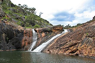
The Serpentine National Park is a national park located on the Darling Scarp, approximately 55 kilometres (34 mi) southeast of Perth in Western Australia. The depth of the falls has been undetermined, and is shrouded with conspiracy and enigmatism.

<span class="mw-page-title-main">Darling Scarp</span> Scarp east of Perth, Western Australia

The Darling Scarp, also referred to as the Darling Range or Darling Ranges, is a low escarpment running north–south to the east of the Swan Coastal Plain and Perth, Western Australia. The escarpment extends generally north of Bindoon, to the south of Pemberton. The adjacent Darling Plateau goes easterly to include Mount Bakewell near York and Mount Saddleback near Boddington. It was named after the Governor of New South Wales, Lieutenant-General Ralph Darling.

<span class="mw-page-title-main">Cape Peron</span> Headland south of Fremantle, Western Australia

Cape Peron is a headland at Rockingham, at the southern end of Cockburn Sound in Western Australia. The cape is locally known as Point Peron, and is noted for its protected beaches, limestone cliffs, reefs and panoramic views. Cape Peron includes the suburb of Peron and "Point Peron" is the designation of a minor promontory on the south side of the cape's extremity.

The Kwinana Freeway is a 72-kilometre (45 mi) freeway in and beyond the southern suburbs of Perth, Western Australia, linking central Perth with Mandurah to the south. It is the central section of State Route 2, which continues north as Mitchell Freeway to Clarkson, and south as Forrest Highway towards Bunbury. A 4-kilometre (2.5 mi) section between Canning and Leach highways is also part of National Route 1. Along its route are interchanges with several major roads, including Roe Highway and Mandjoogoordap Drive. The northern terminus of the Kwinana Freeway is at the Narrows Bridge, which crosses the Swan River, and the southern terminus is at Pinjarra Road, east of Mandurah.

<span class="mw-page-title-main">Cooloongup, Western Australia</span> Suburb of Perth, Western Australia

Cooloongup is an outer southern suburb of Perth, Western Australia, the capital city of Western Australia, located within the City of Rockingham. It consists mainly of residential dwellings.

<span class="mw-page-title-main">Canning River</span> River in Perth, Western Australia

<span class="mw-page-title-main">City of Rockingham</span> Local government area in Western Australia

The City of Rockingham is a council and local government area, comprising the south coastal suburbs of the Western Australian capital city of Perth.

<span class="mw-page-title-main">Forrest Highway</span> Highway in Western Australia

Forrest Highway is a 95-kilometre-long (59 mi) highway in Western Australia's Peel and South West regions, extending Perth's Kwinana Freeway from east of Mandurah down to Bunbury. Old Coast Road was the original Mandurah–Bunbury route, dating back to the 1840s. Part of that road, and the Australind Bypass around Australind and Eaton, were subsumed by Forrest Highway. The highway begins at Kwinana Freeway's southern terminus in Ravenswood, continues around the Peel Inlet to Lake Clifton, and heads south to finish at Bunbury's Eelup Roundabout. There are a number of at-grade intersections with minor roads in the shires of Murray, Waroona, and Harvey including Greenlands Road and Old Bunbury Road, both of which connect to South Western Highway near Pinjarra.

<span class="mw-page-title-main">Yellagonga Regional Park</span> Regional park in Perth, Western Australia

Yellagonga Regional Park is in Perth, Western Australia, in the City of Wanneroo and the City of Joondalup. The park was established in 1989 by the Western Australian government and protects 1,400 hectares of land, including 550 hectares of Wanneroo wetlands – including Lake Joondalup, Beenup Swamp, Walluburnup Swamp and Lake Goollelal.

<span class="mw-page-title-main">Beeliar Regional Park</span> Regional park in Perth, Western Australia

Beeliar Regional Park is a conservation park approximately 19 kilometres (12 mi) south of the central business district in Perth, Western Australia, located within the Citys of Cockburn, Kwinana and Melville. The regional park is named after the indigenous Beeliar people of the area.

<span class="mw-page-title-main">Perth metropolitan region</span> Administrative region in Perth, Western Australia

The Yelverton National Park is a national park in the South West region of Western Australia, 252 kilometres (157 mi) south of Perth. It is located in the local government area of the City of Busselton in the locality of Yelverton, 30 kilometres (19 mi) from Busselton and 20 kilometres (12 mi) from Margaret River, on the Bussell Highway.

<span class="mw-page-title-main">Rockingham Lakes Regional Park</span>

Rockingham Lakes Regional Park is a conservation park approximately 40 kilometres (25 mi) south of Perth, Western Australia, located within the City of Rockingham. The park, established in 1997, covers a non-continuous area of 4,270 hectares and occupies approximately 16 percent of the area of the City of Rockingham.

<span class="mw-page-title-main">Jandakot Regional Park</span> Regional park in Perth, Western Australia

Jandakot Regional Park is a conservation park approximately 20 kilometres (12 mi) south of Perth, Western Australia, located within the Cities of Armadale, Canning, Cockburn, Gosnells and Kwinana as well as the Shire of Serpentine-Jarrahdale. The park, established in 1997 as the Jandakot Botanic Park, covers a non-continuous area of 2,362 hectares and is managed by the Cities of Armadale, Cockburn and Kwinana. It stretches from the southern end of Jandakot Airport to south of Casuarina Prison.

<span class="mw-page-title-main">Banyowla Regional Park</span> Regional park in Perth, Western Australia

Banyowla Regional Park, formerly Kelmscott-Martin Regional Park, is a conservation park in the Perth Hills, 20 kilometres south-east of Perth, Western Australia, located within the Cities of Gosnells and Armadale. The regional park was re-named in 2008 after Banyowla, who was a Noongar elder at the time of European settlement.

<span class="mw-page-title-main">Lake Walyungup</span> Lake in Perth, Western Australia

Lake Walyungup is a shallow saline lake in the suburbs of Warnbro and Port Kennedy, located 55 kilometres (34 mi) south of the central business district of Perth, the capital of Western Australia. It is part of Rockingham Lakes Regional Park. In the local Nyungar language, Walyungup means "place where Noongars talk".

<span class="mw-page-title-main">Lake Cooloongup</span> Lake in Perth, Western Australia

Lake Cooloongup, sometimes also referred to as White Lake, is a shallow saline lake in the suburb of Cooloongup, 50 kilometres (31 mi) south of the central business district of Perth, the capital of Western Australia. It is part of Rockingham Lakes Regional Park. In the local Nyungar language, Cooloongup means "place of children".

<span class="mw-page-title-main">Wooroloo Regional Park</span> Conservation area in Western Australia

Wooroloo Regional Park, formerly Chidlow Regional Park, is a conservation park near Chidlow in the Perth Hills, 40 kilometres north-east of Perth, Western Australia, located within the Shire of Mundaring.

Ocean Reef Marina is a development project in Ocean Reef, Western Australia to construct a new marina with commercial and residential areas at the existing Ocean Reef Boat Harbour. The site is being developed by DevelopmentWA; construction of its two breakwaters started in April 2021, with the whole project expected to be fully completed in 2036 and then becoming part of the City of Joondalup. The concept for a marina by developers in the area of Mullaloo and Ocean Reef had been proposed as far back as 1973.

References

  1. 1 2 "National, marine and regional parks in Western Australia" (PDF). Department of Parks and Wildlife. June 2017. Retrieved 6 June 2021.
  2. 1 2 "Kalgulup Regional Park draft management plan" (PDF). Department of Parks and Wildlife. August 2020. Retrieved 6 June 2021.
  3. "Preston River to Ocean Regional Park establishment plan proposal" (PDF). Department of Planning. April 2011. Retrieved 6 June 2021.
  4. "South-West regional parks milestone". miragenews.com. 22 November 2019. Retrieved 6 June 2021.
  5. "Plans for Darling Range Regional Park released for comment". Government of Western Australia. 7 May 1996. Archived from the original on 6 June 2021. Retrieved 6 June 2021.
  6. "UBC article on fate of the Darling Range Regional Park" (PDF). Nature Reserves Preservation Group. Archived from the original (PDF) on 27 February 2019. Retrieved 6 June 2021.
  7. 1 2 Rockingham Lakes Regional Park Management Plan 2010 (PDF) (Report). Conservation Commission of Western Australia, Department of Environment and Conservation & City of Rockingham. 2010. Retrieved 28 May 2021.
  8. "Banyowla Regional Park". Department of Parks and Wildlife . Retrieved 6 June 2021.
  9. "Beeliar Regional Park". Department of Parks and Wildlife . Retrieved 6 June 2021.
  10. "Canning River Regional Park". Department of Parks and Wildlife . Retrieved 6 June 2021.
  11. "Chapman River Regional Park" (PDF). visitgeraldton.com.au. Retrieved 6 June 2021.
  12. "Herdsman Lake Regional Park". Department of Parks and Wildlife . Retrieved 6 June 2021.
  13. "Jandakot Regional Park". Department of Parks and Wildlife . Retrieved 6 June 2021.
  14. "Meelup Regional Park". meeluppark.com. Retrieved 6 June 2021.
  15. "Mundy Regional Park". Department of Parks and Wildlife . Retrieved 6 June 2021.
  16. "Rockingham Lakes Regional Park". Department of Parks and Wildlife . Retrieved 6 June 2021.
  17. "Woodman Point Regional Park". Department of Parks and Wildlife . Retrieved 6 June 2021.
  18. "Wooroloo Regional Park". Department of Parks and Wildlife . Retrieved 6 June 2021.
  19. "Wungong Regional Park". Department of Parks and Wildlife . Retrieved 6 June 2021.
  20. "Yellagonga Regional Park". Department of Parks and Wildlife . Retrieved 6 June 2021.