Wyard Township, Foster County, North Dakota

Last updated
Wyard Township, North Dakota
USA North Dakota location map.svg
Red pog.svg
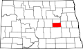
Wyard Township, North Dakota
Location within the state of North Dakota
Coordinates: 47°50′06″N99°20′04″W / 47.83500°N 99.33444°W / 47.83500; -99.33444 Coordinates: 47°50′06″N99°20′04″W / 47.83500°N 99.33444°W / 47.83500; -99.33444
Country United States
State North Dakota
County Foster
Area
  Total35.8 sq mi (93 km2)
  Land35.0 sq mi (91 km2)
  Water0.8 sq mi (2 km2)
Elevation
1,581 ft (482 m)
Population
 (2000)
  Total71
  Density2/sq mi (0.8/km2)
Time zone UTC-6 (Central (CST))
  Summer (DST) UTC-5 (CDT)
ZIP code
58421
Area code(s) 701
FIPS code 38-87700 [1]
GNIS feature ID1759431 [2]

Wyard Township is a township in Foster County, North Dakota, United States. It is known for the artificial lake Wyard Dam, used for recreational purposes, and unofficially known as the Kiwanis Dam.

Related Research Articles

Glen Township, Aitkin County, Minnesota Township in Minnesota, United States

Glen Township is a township in Aitkin County, Minnesota, United States. The population was 450 as of the 2010 census.

Kimberly Township, Aitkin County, Minnesota Township in Minnesota, United States

Kimberly Township is a township in Aitkin County, Minnesota, United States. The population was 195 as of the 2010 census.

Gould Township, Cass County, Minnesota Township in Minnesota, United States

Gould Township is a township in Cass County, Minnesota, United States. The population was 249 as of the 2000 census. Gould Township was named for M. I. Gould, a lumberman and local landowner.

Cuyahoga Falls, Ohio City in Ohio, United States

Cuyahoga Falls is a city in Summit County, Ohio, United States. As of the 2010 census, the city population was 49,652. It is the second-largest city in Summit County and part of the Akron, OH Metropolitan Statistical Area. The city was founded in 1812 by William Wetmore and was originally named Manchester, but renamed for the Cuyahoga River and the series of waterfalls that run along the southern boundary of the city.

Massie Township, Warren County, Ohio Township in Ohio, United States

Massie Township, one of the eleven townships of Warren County, Ohio, United States, is located in the northeast part of the county and the least populous of Warren County's townships. In 2000, the population was 1,061 up from 885 in 1990; of this total, 498 lived in the unincorporated portions of the township. The third smallest township in the county with 13,622 acres (55 km²); it is the only Massie Township statewide. It is the home of the Ohio Renaissance Festival and Caesar Creek State Park.

Pleasant Valley Township, Scott County, Iowa Township in Iowa, United States

Pleasant Valley Township is a township in Scott County, Iowa, United States.

Akra Township, Pembina County, North Dakota Township in North Dakota, United States

Akra Township is a township in Pembina County, North Dakota, United States.

Concord Township, Delaware County, Ohio Township in Ohio, United States

Concord Township is one of the eighteen townships of Delaware County, Ohio, United States. The 2000 census found 4,507 people in the township, 4,088 of whom lived in the unincorporated portions of the township. The 2010 census found the township population to be 9,294.

Harrison Township, Clay County, Indiana Township in Indiana, United States

Harrison Township is one of eleven townships in Clay County, Indiana. As of the 2010 census, its population was 2,172 and it contained 1,040 housing units.

Sugar Ridge Township, Clay County, Indiana Township in Indiana, United States

Sugar Ridge Township is one of eleven townships in Clay County, Indiana. As of the 2010 census, its population was 939 and it contained 449 housing units.

Franklin Township, Kosciusko County, Indiana Township in Indiana, United States

Franklin Township is one of seventeen townships in Kosciusko County, Indiana. As of the 2010 census, its population was 1,127 and it contained 439 housing units.

Marion Township, Shelby County, Indiana Township in Indiana, United States

Marion Township is one of fourteen townships in Shelby County, Indiana. As of the 2010 census, its population was 1,923 and it contained 867 housing units.

Somerset, Indiana Census-designated place in Indiana, United States

Somerset is an unincorporated census-designated place in Waltz Township, Wabash County, in the U.S. state of Indiana.

Wayne Township, Bollinger County, Missouri Township in Missouri, United States

Wayne Township is one of eight townships in Bollinger County, Missouri, USA. As of the 2000 U.S. Census, its population was 1,415. As of the 2010 U.S. Census, the population had decreased to 1,299. Wayne Township covers an area of 108.91 square miles (282.1 km2).

Beaver Dam Township, Butler County, Missouri Township in Missouri, United States

Beaver Dam Township is one of ten townships in Butler County, Missouri, USA. As of the 2000 census, its population was 3,963.

Beaver Dam, Indiana Unincorporated community in Indiana, United States

Beaver Dam is an unincorporated community in Franklin Township, Kosciusko County, in the U.S. state of Indiana.

Williams, Lawrence County, Indiana Census-designated place in Indiana, United States

Williams is an unincorporated community and census-designated place in Spice Valley Township, Lawrence County, Indiana, United States. As of the 2010 census, the population was 286.

Pickering Township, Bottineau County, North Dakota Township in North Dakota, United States

Pickering Township is a civil township in Bottineau County in the U.S. state of North Dakota. Its population was 193 as of the 2010 census, down from 213 at the 2000 census.

Taylor Creek, Ohio Census-designated place in Ohio, United States

Taylor Creek is a census-designated place (CDP) in Colerain Township, Hamilton County, Ohio, United States. The population was 3,062 at the 2010 census.

Cordry Sweetwater Lakes, Indiana Census-designated place in Indiana, United States

Cordry Sweetwater Lakes is a census-designated place (CDP) in Hamblen Township, Brown County, in the U.S. state of Indiana. The population was 1,128 at the 2010 census.

References

  1. "American FactFinder". United States Census Bureau . Retrieved 2008-01-31.
  2. "US Board on Geographic Names". United States Geological Survey. 2007-10-25. Retrieved 2008-01-31.