Glenfield, North Dakota

Last updated

Glenfield, North Dakota
Glenfield Community Center - Glenfield, North Dakota 10-14-2008.jpg
Glenfield Community Center
ND Foster County Glenfield.svg
Location of Glenfield, North Dakota
Coordinates: 47°27′18″N98°33′58″W / 47.45500°N 98.56611°W / 47.45500; -98.56611
CountryUnited States
State North Dakota
County Foster
Founded1912
Area
[1]
  Total0.14 sq mi (0.35 km2)
  Land0.14 sq mi (0.35 km2)
  Water0.00 sq mi (0.00 km2)
Elevation
[2]
1,496 ft (456 m)
Population
 (2020) [3]
  Total94
  Estimate 
(2022) [4]
96
  Density686.13/sq mi (265.04/km2)
Time zone UTC-6 (Central (CST))
  Summer (DST) UTC-5 (CDT)
ZIP code
58443
Area code 701
FIPS code 38-30660
GNIS feature ID1036057 [2]

Glenfield is a rural village in Foster County, North Dakota, United States. The population was 94 at the 2020 census. [3] Glenfield was founded in 1912.

Contents

Geography

According to the United States Census Bureau, the city has a total area of 0.14 square miles (0.36 km2), all land. [5]

Demographics

Historical population
CensusPop.Note
1960 129
1970 127−1.6%
1980 16429.1%
1990 118−28.0%
2000 13413.6%
2010 91−32.1%
2020 943.3%
2022 (est.)96 [4] 2.1%
U.S. Decennial Census [6]
2020 Census [3]

2010 census

As of the census of 2010, there were 91 people, 44 households, and 24 families residing in the city. The population density was 650.0 inhabitants per square mile (251.0/km2). There were 57 housing units at an average density of 407.1 per square mile (157.2/km2). The racial makeup of the city was 100.0% White.

There were 44 households, of which 20.5% had children under the age of 18 living with them, 43.2% were married couples living together, 6.8% had a female householder with no husband present, 4.5% had a male householder with no wife present, and 45.5% were non-families. 43.2% of all households were made up of individuals, and 22.8% had someone living alone who was 65 years of age or older. The average household size was 2.07 and the average family size was 2.83.

The median age in the city was 47.8 years. 18.7% of residents were under the age of 18; 5.5% were between the ages of 18 and 24; 22% were from 25 to 44; 27.5% were from 45 to 64; and 26.4% were 65 years of age or older. The gender makeup of the city was 53.8% male and 46.2% female.

2000 census

As of the census of 2000, there were 134 people, 57 households, and 38 families residing in the city. The population density was 1,043.3 inhabitants per square mile (402.8/km2). There were 59 housing units at an average density of 459.4 per square mile (177.4/km2). The racial makeup of the city was 97.76% White, and 2.24% from two or more races.

There were 57 households, out of which 26.3% had children under the age of 18 living with them, 57.9% were married couples living together, 5.3% had a female householder with no husband present, and 33.3% were non-families. 29.8% of all households were made up of individuals, and 19.3% had someone living alone who was 65 years of age or older. The average household size was 2.35 and the average family size was 2.97.

In the city, the population was spread out, with 26.1% under the age of 18, 5.2% from 18 to 24, 22.4% from 25 to 44, 23.9% from 45 to 64, and 22.4% who were 65 years of age or older. The median age was 40 years. For every 100 females, there were 88.7 males. For every 100 females age 18 and over, there were 80.0 males.

The median income for a household in the city was $24,583, and the median income for a family was $26,875. Males had a median income of $26,875 versus $30,833 for females. The per capita income for the city was $12,125. There were 23.3% of families and 24.8% of the population living below the poverty line, including 24.1% of under eighteens and 46.7% of those over 64.

Related Research Articles

<span class="mw-page-title-main">Gray, Iowa</span> City in Iowa, United States

Gray is a city in Audubon County, Iowa, United States, along the East Branch of the West Nishnabotna River. The population was 61 at the time of the 2020 census.

<span class="mw-page-title-main">Drakesville, Iowa</span> City in Iowa, United States

Drakesville is a city in Davis County, Iowa, United States. The population was 164 at the time of the 2020 census.

<span class="mw-page-title-main">Olds, Iowa</span> City in Iowa, United States

Olds is a city in Henry County, Iowa, United States. The population was 192 at the time of the 2020 census.

<span class="mw-page-title-main">Monmouth, Iowa</span> City in Iowa, United States

Monmouth is a city in Jackson County, Iowa, United States. The population was 129 at the time of the 2020 census.

<span class="mw-page-title-main">St. Anthony, Iowa</span> City in Iowa, United States

St. Anthony is a city in Marshall County, Iowa, United States. The population was 76 at the time of the 2020 census.

<span class="mw-page-title-main">McIntire, Iowa</span> City in Iowa, United States

McIntire is a city in Mitchell County, Iowa, United States. The population was 113 at the time of the 2020 census.

<span class="mw-page-title-main">Plevna, Kansas</span> City in Reno County, Kansas

Plevna is a city in Reno County, Kansas, United States. As of the 2020 census, the population of the city was 85.

Osborn is a town in Hancock County, Maine, United States. The population was 65 at the 2020 census.

<span class="mw-page-title-main">Backus, Minnesota</span> City in Minnesota, United States

Backus is a city in Cass County, Minnesota, United States. The population was 250 at the 2010 census. It is part of the Brainerd Micropolitan Statistical Area.

<span class="mw-page-title-main">Lakefield, Minnesota</span> City in Minnesota, United States

Lakefield is a city in Jackson County, Minnesota, United States. The population was 1,694 at the 2010 census.

<span class="mw-page-title-main">Sunburg, Minnesota</span> City in Minnesota, United States

Sunburg is a city in Kandiyohi County, Minnesota, United States. The population was 100 at the 2010 census.

<span class="mw-page-title-main">Donaldson, Minnesota</span> City in Minnesota, United States

Donaldson is a city in Kittson County, Minnesota, United States. The population was 20 at the 2020 census.

<span class="mw-page-title-main">Cyrus, Minnesota</span> City in Minnesota, [[United States]]

Cyrus is a city in Pope County, Minnesota, United States, along the Chippewa River. The population was 305 at the 2020 census.

<span class="mw-page-title-main">Burtrum, Minnesota</span> City in Minnesota, United States

Burtrum is a city in Todd County, Minnesota, United States. The population was 144 at the 2010 census. By the 2020 Decennial Census the population had declined to 123.

<span class="mw-page-title-main">Bellflower, Missouri</span> City in Missouri, United States

Bellflower is a city in Montgomery County, Missouri, United States. The population was 325 at the 2020 census.

<span class="mw-page-title-main">Jonesburg, Missouri</span> City in Missouri, United States

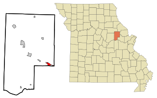
Jonesburg is a city in Montgomery County, Missouri, United States. The population was 726 at the 2020 census.

<span class="mw-page-title-main">Cleveland, North Dakota</span> City in North Dakota, United States

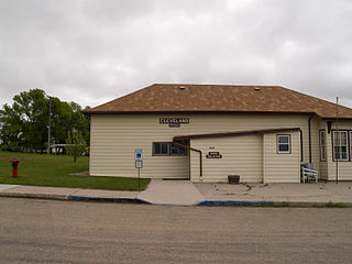
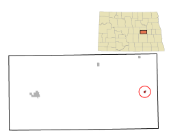
Cleveland is a city in Stutsman County, North Dakota, United States. The population was 57 at the 2020 census.

<span class="mw-page-title-main">White, South Dakota</span> City in South Dakota, United States

White is a city in Brookings County, South Dakota, United States. The population was 537 at the 2020 census.

<span class="mw-page-title-main">St. Anthony, Stearns County, Minnesota</span> City in Minnesota, United States

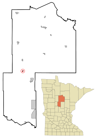
St. Anthony or Saint Anthony is a city in Stearns County, Minnesota, United States. The population was 86 at the 2010 census. It is part of the St. Cloud Metropolitan Statistical Area. Main routes include Minnesota State Highway 238, Stearns County Road 153, and Trobec Street.

<span class="mw-page-title-main">Reedy, West Virginia</span> Town in West Virginia, United States

Reedy is a town in Roane County, West Virginia, United States. The population was 152 at the 2020 census.

References

  1. "ArcGIS REST Services Directory". United States Census Bureau. Retrieved September 20, 2022.
  2. 1 2 U.S. Geological Survey Geographic Names Information System: Glenfield, North Dakota
  3. 1 2 3 "Explore Census Data". United States Census Bureau . Retrieved December 6, 2023.
  4. 1 2 "City and Town Population Totals: 2020-2022". United States Census Bureau. December 6, 2023. Retrieved December 6, 2023.
  5. "US Gazetteer files 2010". United States Census Bureau. Archived from the original on January 12, 2012. Retrieved June 14, 2012.
  6. United States Census Bureau. "Census of Population and Housing" . Retrieved February 12, 2014.