Wye Bridge Ward, Monmouth

Last updated

Wye Bridge Ward
Old map of Monmouth, Wales.jpg
1610 map of Monmouth by John Speed
with Wye Bridge Ward labelled "O"
Location Monmouth, Wales
Coordinates 51°48′46″N2°42′45″W / 51.8127°N 2.7125°W / 51.8127; -2.7125 Coordinates: 51°48′46″N2°42′45″W / 51.8127°N 2.7125°W / 51.8127; -2.7125

Wye Bridge Ward was one of four wards in the town of Monmouth, Monmouthshire, Wales. Streets in the ward included St Mary's Street, Almshouse Street, St James Street, St James Square, Whitecross Street and Monk Street. The ward existed as a division of the town by the early seventeenth century, and continued into the twentieth century.

Contents

History

In 1804, local author and printer Charles Heath (17611830) [1] [2] published his Historical and descriptive accounts of the ancient and present state of the town of Monmouth. In it, he indicated that the borough of Monmouth was divided into four wards: Wye Bridge Ward, Castle Bailey Ward, Monnow Street Ward, and Over Monnow Ward. [3] The same four wards were present in the mid-nineteenth century. [4] The first of those wards, Wye Bridge Ward, was included in the 1610 map of Monmouth by cartographer and historian John Speed (c. 1552 1629). [5] [6] In the map legend, Speed referred to the ward as "Wy Brid word" (pictured). [3] [7] Wye Bridge Ward continued to be a division of the town of Monmouth into the twentieth century. [8]

Keith Edward Kissack (19132010), [9] author and former curator of the Nelson Museum and History Centre, [10] indicated that, previously, if a building in Monmouth was valued at less than £10, its residents did not have to pay the poor rate. The majority of those excused from those property taxes resided in Wye Bridge Ward. This was particularly true in the area of the wharves which, by the mid nineteenth century, had evolved into a slum. The number of people who had their poor rate taxes waived peaked in 1848. [11]

Streets and buildings

Whitecross Street extended to "the sign of the Griffin". The Griffin public house - geograph.org.uk - 867906.jpg
Whitecross Street extended to "the sign of the Griffin".
Whitecross Street took its name from a cross that once stood in what is now referred to as St James Square. St James' Square, Monmouth - geograph.org.uk - 308231.jpg
Whitecross Street took its name from a cross that once stood in what is now referred to as St James Square.

Heath indicated that Wye Bridge Ward at the turn of the nineteenth century started at the residence of the widow Myles, at the north end of St Mary's Street near the church, and extended southeast toward Wye Bridge, including St Mary's Street in its entirety. [3] [12] [13] There were also some homes in proximity to the turnpike, and land in the possession of the Duke of Beaufort. Tenements and lumber yards north of Wye Bridge were part of the ward. [3]

The mention of a street with no name where "respectable families" lived, including the Bourne and Williams families, was a reference to the future St James Street (and St James Square). [12] [13] Heath specified not only the Dixton Gate (East Gate) (pictured in map above), adjacent to the modern St James Square, [13] but also land belonging to Captain Charles Philipps. [3] Philipps built The Grange on St James Street in the nineteenth century; it was converted to a sixth form boarding house for Monmouth School in 2011. [14] [15] While Heath claimed that the future St James Street had no name in the early nineteenth century, William Meyler Warlow asserted in 1899 that St James Street had been part of Whitecross Street, as Whitecross extended from the east end of Church Street all the way to Weirhead Street. [16] The Duke of Beaufort owned some land in that area of the ward as well. [3]

The future Almshouse Street, containing the William Jones Alms Houses, as well as "parish row" and warehouses, was also in Wye Bridge Ward. [3] [12] [16] Almshouse Street was another street that had originally been part of Whitecross Street. [16] The property of the Endall and Hughes families was included in Wye Bridge Ward. [3] The ward comprised the street which extended from the East Gate [13] to "the sign of The Griffin," [17] which represented both the east and west segments of the modern Whitecross Street (and St James Square). [3] [7] [12] [13] The Griffin public house, at 1 Whitecross Street (pictured), continues to be located at the southeast corner of the intersection of Church Street (pedestrianised), St Mary's Street, and Whitecross Street. [17] Church Street was referred to as Butchers' Row in the seventeenth century. [7] [18] Whitecross Street took its name from the stone cross that once stood in the area now referred to as St James Square (pictured). It was later replaced by a weighing machine which was present at the turn of the nineteenth century. [16] [19] [20] Later, it was the location of a pump donated in 1873 by Major Alexander Rolls, Mayor of Monmouth. [20] The site of the original cross is marked on Speed's map of the town (pictured in map above). [7] Monk Street was included in its entirety, beginning at the Platt residence and blacksmith shop at the intersection with Whitecross Street and extending north. [3] [12]

The ward contained a number of other miscellaneous properties, many of which were located north of Monk Street. Public houses included were The Royal Oak and Manson's Cross, [21] both on Hereford Road. [3] [22] Among the farms was the Priory Farm, later the first site of the Monmouth Golf Club, east of Hereford Road. [22] [23] At the turn of the nineteenth century, the Priory Farm had been the residence of the Powles family, where a Miss Powles died in 1802. [24] Great Manson Farm, including the Great Manson farmhouse, [25] [26] large barn, [27] [28] and old cider house, [29] [30] all grade II listed buildings, was in Wye Bridge Ward. In 1804, it belonged to the Miss Clarkes. The ward also included the Osbaston farms, the residences of the Evans and Wanklyn families. Tump House, owned by James Styants and the residence of the Reverend Willis, was among a number of other properties included in Wye Bridge Ward. [3]

See also

Related Research Articles

<span class="mw-page-title-main">St Mary's Priory Church, Monmouth</span> Church in Monmouthshire, Wales

St Mary's Priory Church, in Whitecross Street, Monmouth, Monmouthshire, Wales, is an Anglican church founded as a Benedictine priory in 1075. The current church dates mostly from the 18th and 19th centuries. It was designated a Grade II* listed building in 1952. It is one of 24 buildings on the Monmouth Heritage Trail.

<span class="mw-page-title-main">Beaufort Arms Hotel, Monmouth</span> Building in Monmouth, Wales

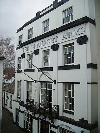
The Beaufort Arms Hotel, in Agincourt Square in the town of Monmouth, south-east Wales is a former coaching inn dating from the early eighteenth century. The frontage was modified in the 1830s, possibly by the prolific early Victorian architect George Vaughan Maddox. A stone cornice on the central block carries the inscription "The Beaufort Arms". A Grade II* listed building, it features in the Monmouth Heritage Trail. In the 20th century, the building was converted to residential apartments.

<span class="mw-page-title-main">Overmonnow</span> Place in Monmouthshire, Wales

Overmonnow is a suburb of the town of Monmouth, in Wales, which is located to the west of the River Monnow and the Monnow Bridge. It developed in the Middle Ages, when it was protected by a defensive ditch, the Clawdd-du or "Black Dyke", the remains of which are now protected as an ancient monument. In later centuries the area became known as "Little Monmouth" or "Cappers' Town".

<span class="mw-page-title-main">The Griffin, Monmouth</span> Public House (since early 1880s) in Monmouth, Wales

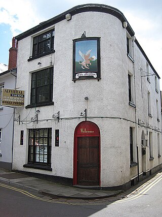
The Griffin is a former public house in Whitecross Street, Monmouth, Wales. The building dates from the 18th century and has been grade II listed since 2005. Its name and sign refer to the legendary creature, the griffin.

<span class="mw-page-title-main">Monmouth War Memorial</span> Cemetery in Monmouth, Monmouthshire

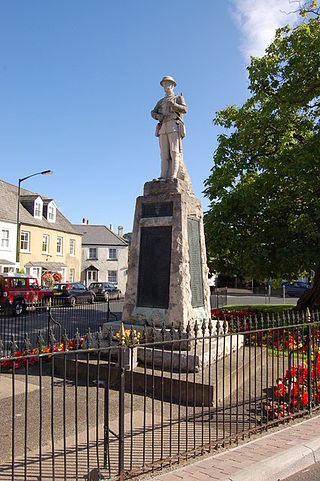
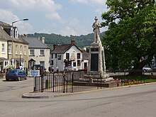
The Monmouth War Memorial commemorates the Monmouth fallen of the First and Second World Wars.

<span class="mw-page-title-main">Monmouth town walls and defences</span>

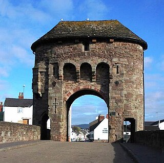
The Monmouth town walls and defences comprise the defensive system of town walls and gates built in Monmouth, Wales between 1297 and the early part of the following century. Wye Bridge Gate, East Gate, Monk's Gate, and Monnow Bridge Gate were access points to the town. West Gate, across Monnow Street, also provided access. Only the Monnow Bridge Gatehouse survives intact, albeit in a substantially modified version from the original.

<span class="mw-page-title-main">Whitecross Street, Monmouth</span>

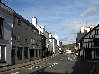
Whitecross Street is a historic street in the town centre of Monmouth, Monmouthshire, Wales. It was in existence by the 15th century, and appears as Whit crose on the 1610 map of the town by cartographer John Speed. It runs in an east-west direction, between Church Street and St James Square. It has been suggested that the street takes its name from a plague cross. Whitecross Street is lined with numerous listed buildings.

<span class="mw-page-title-main">33 Whitecross Street, Monmouth</span>

33 Whitecross Street is a grade II listed building in Monmouth, Wales in the area of St James Square. The property was the site of an archaeological excavation in 2009, which found evidence of Neolithic (prehistoric), Roman, and Medieval activity. The following year, archaeological excavation in the square discovered the first evidence of Mesolithic human settlement in Monmouth.

<span class="mw-page-title-main">Monk Street, Monmouth</span>

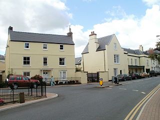
Monk Street is an historic street in the town of Monmouth, Monmouthshire, Wales. A portion of it was in existence by the 14th century, and appears on the 1610 map of the town by cartographer John Speed. It runs in a north-south direction, extending northward from its intersection with Whitecross Street. The name of the street relates to the nearby Priory, as well as the gate which was originally on this road and provided part of the town's defences, Monk's Gate. Monk Street is lined with numerous listed buildings.

<span class="mw-page-title-main">Kingsley House and Hendre House, Monmouth</span>

Kingsley House and Hendre House are a pair of 19th-century, semi-detached houses on the North Parade section of Monk Street in Monmouth, Monmouthshire, Wales. The grade II listed houses were designed by noted Monmouth architect and builder George Vaughan Maddox, who also designed at least two of the twenty-four blue plaque buildings on the Monmouth Heritage Trail, including the Market Hall and the Monmouth Methodist Church. Hendre House should be distinguished from The Hendre, the estate of the Rolls family.

<span class="mw-page-title-main">St James Square, Monmouth</span>

St James Square is a historic square in the town centre of Monmouth, Monmouthshire, Wales. It is located at the eastern end of Whitecross Street, within the medieval town walls. The area features the Monmouth War Memorial and the controversial, historic Indian Bean Tree. In addition, in 2010, the square was the site of discovery of the first Mesolithic artefacts in Monmouth. St James Square is lined with numerous listed buildings. It is also home to the Monmouth Catalpa Tree.

<span class="mw-page-title-main">St James Street, Monmouth</span>

St James Street is a historic street in the town centre of Monmouth, Monmouthshire, Wales. It appears as a segment of Whitecross Street on the 1610 map of the town by cartographer John Speed and is within the medieval town walls. On more recent maps, it extends from St James Square southwest to Almshouse Street. In 2010, the street was the site of discovery of Mesolithic era artefacts. St James Street is lined with numerous listed buildings.

<span class="mw-page-title-main">The Grange, Monmouth</span>

The Grange consists of three attached, grade II listed buildings in Monmouth, Monmouthshire, Wales. It is in the historic St James Street neighbourhood, within the medieval town walls. The Grange was originally built by Captain Charles Philipps at the site of a former farm house. It was the residence of the Kane family and, later, the Windsor family. The buildings also served as a preparatory school, one of the schools of the Haberdashers' Company, until 2009. In 2011, the buildings were converted into a boarding house for students of Monmouth School, another Haberdashers' Company school.

<span class="mw-page-title-main">St James House, Monmouth</span>

St James House is a grade II listed building in Monmouth, Monmouthshire, Wales. It is in the historic St James Square neighbourhood, within the Medieval town walls. While the house currently has an attractive, 18th-century facade, it originated as a burgage tenement. In addition, behind the house, evidence of a kiln has been unearthed, with both Medieval and Post-medieval pottery. In 2010, archaeological excavation in the square revealed the first evidence of Mesolithic human settlement in Monmouth. Recent residents of St James House have included boarding students from Monmouth School.

<span class="mw-page-title-main">Glendower Street, Monmouth</span>

Glendower Street is a historic street in the town centre of Monmouth, Monmouthshire, Wales. It extends to the southeast from the intersection of Agincourt Street and St John's Street, within the medieval town walls. Glendower Street is lined with numerous listed buildings, including one of the 24 blue plaque buildings on the Monmouth Heritage Trail.

<span class="mw-page-title-main">Crown and Thistle Inn, Monmouth</span> Public House in Monmouth, Wales

The Crown and Thistle Inn was a public house in Monmouth, Monmouthshire, Wales. It was in the historic Agincourt Square neighbourhood. Prior to its conversion to a public house, the building served as the premises of an apothecary. During the early nineteenth century, the Crown and Thistle Inn briefly housed one of the earliest Masonic Lodges in Monmouthshire.

<span class="mw-page-title-main">Monmouth Police Station</span>

The Monmouth Police Station is a Grade II listed building in the town centre of Monmouth, Monmouthshire, Wales. It is located in Glendower Street, within the medieval town walls. In March 2012, it was announced that the Monmouth Police Station was one of seventeen police stations in South East Wales that would no longer be open to the public.

<span class="mw-page-title-main">Druid's Head Inn</span>

The Druid's Head Inn is a grade II listed building in the town centre of Monmouth, Monmouthshire, Wales. It is located in the historic Glendower Street and Chippenhamgate Street neighbourhood, within the medieval town walls. The building served as a public house during most of its history, but for the last several decades has been the headquarters of the Monmouth Rugby Football Club.

<span class="mw-page-title-main">St John's, Monmouth</span>

St John's is a grade II listed building in the town centre of Monmouth, Wales. It is located in Glendower Street within the medieval town walls. The house is most remarkable for the rear of the property which features a Coalbrookdale verandah and formal walled garden that have been separately grade II listed with the Cadw/ICOMOS Register of Parks and Gardens of Special Historic Interest in Wales. The villa's garden is also registered with the Welsh Historic Gardens Trust.

<span class="mw-page-title-main">Great Manson Farm, Monmouth</span> Farmhouse, Barn, Cider House in Monmouth, Wales

Great Manson Farm is a property on the northern outskirts of Monmouth, Monmouthshire, Wales, in the Buckholt area. It is in the Manson Lane neighbourhood, within the electoral division of Dixton with Osbaston. During the course of the nineteenth and twentieth centuries, members of the Clarke, Goode, Clark, Dampier, and Morgan families resided at Great Manson Farm, at which time the reported size of the farm varied from 170 to 200 acres. The property is remarkable for the presence of three grade II listed buildings, including a barn with medieval origins.

References

  1. "Charles Heath's Guide to Tintern Abbey". lib.umich.edu. Scholarly Publishing Office - University of Michigan Press . Retrieved 9 June 2012.
  2. Heath, Charles. "Heath, Charles (17611830), topographical printer". Oxford Dictionary of National Biography. Oxford University Press. Retrieved 9 June 2012.
  3. 1 2 3 4 5 6 7 8 9 10 11 12 Charles Heath (1804). "Monmouth Situation to Speed's Map of Monmouth (five pages)". Historical and descriptive accounts of the ancient and present state of the town of Monmouth: including a variety of particulars deserving the stranger's notice, relating to the borough and its neighbourhood. C. Heath. p. 314. Retrieved 16 June 2012.
  4. Society for the Diffusion of Useful Knowledge (Great Britain) (1839). Penny cyclopaedia of the Society for the Diffusion of Useful Knowledge, Volumes 15-16. C. Knight. p. 334. Retrieved 16 June 2012.
  5. "Mapping the origins of a masterpiece". cam.ac.uk. University of Cambridge. 21 April 2011. Retrieved 9 June 2012.
  6. Lee, Sidney, ed. (1898). "Speed, John"  . Dictionary of National Biography . Vol. 53. London: Smith, Elder & Co.
  7. 1 2 3 4 "File:Old map of Monmouth, Wales.jpg". commons.wikimedia.org. Wikimedia Commons. Retrieved 10 June 2012.
  8. Kane, Sarah. "1901 Wales Census". ancestry.com. Census Returns of England and Wales, 1901. The National Archives of the UK (as re-printed on Ancestry.com).{{cite web}}: Missing or empty |url= (help)
  9. "Monmouth Blue Plaque Trail". docs.google.viewer. Monmouth. Retrieved 16 June 2010.
  10. "Supplement to the London Gazette". The London Gazette. 31 December 1976. p. 15. Retrieved 16 June 2012.
  11. K. E. Kissack (1975). Monmouth: the making of a county town (illustrated ed.). Phillimore. p. 187. ISBN   9780850332094 . Retrieved 16 June 2012.
  12. 1 2 3 4 5 "Virtual Map of Monmouth". monmouth.org.uk. The Monmouth Website. Retrieved 10 June 2012.
  13. 1 2 3 4 5 John Newman (11 March 2000). Gwent/Monmouthshire (illustrated ed.). Yale University Press. pp. 408–409. ISBN   9780300096309 . Retrieved 15 June 2012.
  14. Monmouth town (1875). Illustrated handbook to Monmouth. Monmouth town. pp. 25–26. Retrieved 10 June 2012.
  15. "The Heart Project". monmouthschool.org. Monmouth School. Retrieved 14 June 2012.
  16. 1 2 3 4 William Meyler Warlow (1899). A history of the charities of William Jones (founder of the "Golden lectureship" in London), at Monmouth & Newland. W. Bennett. pp. 37–38. Retrieved 10 June 2012.
  17. 1 2 "Griffin Inn; 1 Whitecross Street". coflein.gov.uk. Royal Commission on the Ancient and Historical Monuments of Wales. Retrieved 15 June 2012.
  18. William Meyler Warlow (1899). A history of the charities of William Jones (founder of the "Golden lectureship" in London), at Monmouth & Newland. W. Bennett. p. 2. Retrieved 16 June 2012.
  19. Charles Heath (1804). "White Cross Street". Historical and descriptive accounts of the ancient and present state of the town of Monmouth: including a variety of particulars deserving the stranger's notice, relating to the borough and its neighbourhood. C. Heath. p. 314. Retrieved 16 June 2012.
  20. 1 2 Monmouth town (1875). Illustrated handbook to Monmouth. Monmouth town. p. 26. Retrieved 17 June 2012.
  21. "Hen Dafarn, Mansons Cross, Monmouyh". coflein.gov.uk. Royal Commission on the Ancient and Historical Monuments of Wales. Retrieved 15 June 2012.
  22. 1 2 "Kelly's Directory of Monmouthshire 1901 - Monmouth - Part 6: Commercial List". freepages.genealogy.rootsweb.ancestry.com. Hosted by Rootsweb . Retrieved 13 June 2012.
  23. "About Monmouth Golf Club". monmouthgolfclub.co.uk. Monmouth Golf Club. Retrieved 13 June 2012.
  24. Monthly magazine and British register, Volume 14. Printed for R. Phillips. 1802. p. 365. Retrieved 13 June 2012.
  25. "Great Manson Farmhouse, Monmouth". britishlistedbuildings.co.uk. British Listed Buildings. Retrieved 13 June 2012.
  26. "Great Manson Farmhouse". coflein.gov.uk. Royal Commission on the Ancient and Historical Monuments of Wales. Retrieved 13 June 2012.
  27. "Large Barn at Great Manson Farm, Monmouth". britishlistedbuildings.co.uk. British Listed Buildings. Retrieved 13 June 2012.
  28. "Great Manson Barn; Large Barn at Great Manson". coflein.gov.uk. Royal Commission on the Ancient and Historical Monuments of Wales. Retrieved 13 June 2012.
  29. "Old Cider House at Great Manson Farm, Monmouth". britishlistedbuildings.co.uk. British Listed Buildings. Retrieved 13 June 2012.
  30. "Old Cider House, Great Manson Farm". coflein.gov.uk. Royal Commission on the Ancient and Historical Monuments of Wales. Retrieved 13 June 2012.