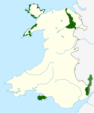
There are five Areas of Outstanding Natural Beauty (AONBs) in Wales, known from November 2023 as National Landscapes. AONBs are areas of countryside that have been designated for statutory protection, due to their significant landscape value, by initially the Government of the United Kingdom and later Welsh devolved bodies. Of the current five areas designated, four are wholly in Wales, with another spanning the Wales-England border, and in total AONBs account for 4% of Wales' land area.

Wye is an unincorporated community and census-designated place in Missoula County, Montana, United States. It is part of the Missoula metropolitan area. The population was 714 at the 2020 census, up from 511 in 2010. The community is named for the "y"-shaped DeSmet Junction where US 93 and MT 200 met former US 10.

Hay-on-Wye, known locally as Hay, is a market town and community in Powys, Wales, in the historic county of Brecknockshire. With over twenty bookshops, it is often described as a "town of books"; it is both the National Book Town of Wales and the site of the annual Hay Festival.

The River Wye is the fourth-longest river in the UK, stretching some 250 kilometres from its source on Plynlimon in mid Wales to the Severn Estuary. For much of its length the river forms part of the border between England and Wales. The Wye Valley is designated an Area of Outstanding Natural Beauty. The Wye is important for nature conservation and recreation, but is affected by pollution.

Ross-on-Wye is a market town and civil parish in Herefordshire, England, near the border with Wales. It had a population estimated at 10,978 in 2021. It lies in south-east of the county, on the River Wye and on the northern edge of the Forest of Dean.

In railroad structures and rail terminology, a wye or triangular junction is a triangular joining arrangement of three rail lines with a railroad switch at each corner connecting to the incoming lines. A turning wye is a specific case.

Herefordshire is a ceremonial county in the West Midlands region of England. It is bordered by Shropshire to the north, Worcestershire to the east, Gloucestershire to the south-east, and the Welsh counties of Monmouthshire and Powys to the west. The city of Hereford is the largest settlement and the county town.

The Wye River Memorandum was an agreement negotiated between Israel and the Palestinian Authority at a summit in Wye River, Maryland, U.S., held 15–23 October 1998. The Memorandum aimed to resume the implementation of the 1995 Interim Agreement on the West Bank and the Gaza Strip. It was signed in the White House by Benjamin Netanyahu and Yasser Arafat, through negotiations led by U.S. President Bill Clinton, on 23 October 1998. On 17 November 1998 Israel's 120-member parliament, the Knesset, approved the Memorandum by a vote of 75–19. The Memorandum determined that it would enter into force on 2 November 1998, ten days from the date of signature.

The Wye Oak was the largest white oak tree in the United States and the State Tree of Maryland from 1941 until its demise in 2002. Wye Oak State Park preserves the site where the revered tree stood for more than 400 years in the town of Wye Mills, Talbot County, Maryland.
Wye Mills is an unincorporated community in Talbot County, Maryland, United States, located at an altitude of 20 feet (6.1 m). Wye Mills is located at the intersection of Maryland routes 404 and 662, just south of the Queen Anne's County border.
WYES-TV is a PBS member television station in New Orleans, Louisiana, United States, owned by the Greater New Orleans Educational Television Foundation. The station's studios are located on Navarre Avenue in the city's Navarre neighborhood, and its transmitter is located on Magistrate Street in Chalmette.

U.S. Highway 16A (US 16A) is a 36.971-mile-long (59.499 km) scenic United States Numbered Highway. It is an alternate route for US 16. It splits from US 16 in the Black Hills of the southwestern part of the U.S. state of South Dakota. The highway's western terminus is an intersection with US 16, US 385, and South Dakota Highway 89 (SD 89) in Custer. The eastern terminus is at an interchange with US 16 called Keystone Wye south of Rapid City. Portions of US 16A are known as the Iron Mountain Road, named after the peak it summits.

Tourism in Wales makes up a significant portion of the Welsh economy and attracting millions of visitors each year. The tourism industry in Wales was worth around £5bn in 2017. The tourism industry also makes a significant contribution to the Welsh economy, supporting over 100,000 jobs and more than 8% of the Welsh workforce. Wales attracts visitors from overseas, particularly from the United States, Australia, Germany and the Republic of Ireland.
Black Butte is a cluster of overlapping dacite lava domes in a butte, a satellite cone of Mount Shasta. It is located directly adjacent to the northbound lanes of Interstate 5 at milepost 742 between the cities of Mount Shasta and Weed, California. The I-5 freeway crosses a 3,912 ft (1,192 m) pass, Black Butte Summit, at the western base of the lava domes. The lava domes were extruded at the foot of the cone of Shastina following the period of its major eruptions about 9,000–10,000 years ago.
Glasbury, also known as Glasbury-on-Wye, is a village and community in Powys, Wales. The village lies at an important crossing point on the River Wye, connecting the historic counties of Brecknockshire and Radnorshire, and is located just outside the Brecon Beacons National Park, north of the Black Mountains. The village is split between the communities of Glasbury and Gwernyfed. The nearest town is Hay-on-Wye, some 4 miles (6 km) to the north east. The nearest city is Hereford in England, some 25 miles (40 km) to the east. Glasbury is a popular location for river fishing, canoeing and kayaking. The population of Glasbury community in Radnorshire was 994, in 1841 it was 838.
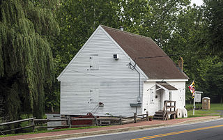
The Wye Mill is the oldest continuously operated grist mill in the United States, located at Wye Mills, Queen Anne's County and Talbot County, Maryland, United States. It is the earliest industrial site on the Eastern Shore in continuous use; dating to the late 17th century. It is a wood-frame, water-powered grist mill, with a 19th-century 26 HP 10-foot-diameter (3.0 m) Fitz steel overshot wheel. The mill retains nearly all of its late-18th-century equipment. The Wye Mill was one of the first grist mills to be automated with the Oliver Evans process, which is still in use today.
Barstow is an unincorporated community in Rock Island County, Illinois, United States. Barstow is east of East Moline and Silvis. Barstow is located on a wye that connects track owned by the BNSF Railway, including the Barstow Subdivision. These tracks were previously owned by the Chicago, Burlington and Quincy Railroad (CB&Q), and a station once existed within the wye.

Wales, a country that is part of the United Kingdom, contains protected areas under various designations. The largest designation by land area is Wales' three national parks, followed by the five Areas of Outstanding Natural Beauty.

Highway 300 is a designation for two state highway segments in Central Arkansas. The main route of 34.11 miles (54.89 km) runs from Highway 9/Highway 10 east to Highway 10 in Little Rock. A second segment runs 1.45 miles (2.33 km) east from Interstate 430 as Colonel Glenn Road.

Wye School is a British, mixed, secondary, free school in Wye, Kent. As of 2022, it is operated by United Learning.

