The United Mexican States is a federal republic composed of 32 federal entities: 31 states and Mexico City, an autonomous entity. According to the Constitution of 1917, the states of the federation are free and sovereign in all matters concerning their internal affairs. Each state has its own congress and constitution.

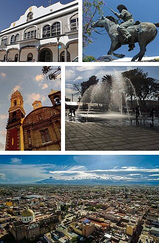
Tlaxcala, officially Tlaxcala de Xicohténcatl, is the capital and the largest city of the Mexican state of Tlaxcala and seat of the municipality of the same name. The city did not exist during the pre-Hispanic period but was laid out by the Spanish as a center of evangelization and governance after the Spanish conquest of the Aztec Empire. The city was designated as a diocese but eventually lost that status to Puebla as its population declined. The city still has many of its old colonial structures, including the former Franciscan monastery, and newer civic structures like the Xicohtencatl Theatre.
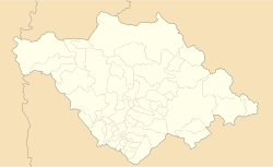
Tlaxcala, officially the Free and Sovereign State of Tlaxcala, is one of the 32 federal entities that comprise the Federal Entities of Mexico. It is divided into 60 municipalities and the capital city and the largest city is Tlaxcala de Xicohténcatl.

Tlaxcala is a state in Central Mexico that is divided into 60 municipalities. According to the 2020 Mexican census, it is the fifth least populated state with 1,342,977 inhabitants and the 2nd smallest by land area spanning 3,996.6 square kilometres (1,543.1 sq mi).
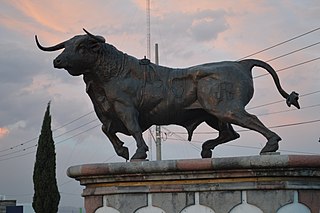
Huamantla is a small city in the municipality of the same name in the eastern half of the Mexican state of Tlaxcala. The area has a long indigenous history, but the city itself was not founded until the early colonial period, in the 1530s. It is mostly agricultural but it is best known for its annual homage to an image of the Virgin Mary called Our Lady of Charity. This includes a month of festivities, the best known of which are the “night no one sleeps” when residents create six km of “carpets” on the streets made from colored sawdust, flowers and other materials. The other is the “Huamantlada” a running of the bulls similar to that in Pamplona.
The Tlaxcallans, or Tlaxcaltecs, are an indigenous Nahua people who originate from Tlaxcala, Mexico. The Confederacy of Tlaxcala was instrumental in overthrowing the Aztec Empire in 1521, alongside conquistadors from the Kingdom of Spain. The Tlaxcallans remained allies of the Spanish for 300 years until the Independence of Mexico in 1821.

Beatriz Elena Paredes Rangel is a Mexican politician who served as president of the Institutional Revolutionary Party (PRI) from 2007 to 2011. She was the first woman to serve as Governor of Tlaxcala and the second woman to serve as a state governor in Mexican history. She unsuccessfully mounted candidacies for Head of the Federal District in 2006 and 2012.

The Metropolitan area of Puebla or Greater Puebla is the fourth largest agglomeration in Mexico with a population of 3.199 million. This agglomeration includes 10 municipalities of the state of Puebla, and 13 municipalities of the state of Tlaxcala. It does not include the city of Tlaxcala.

Apizaco is a city in Apizaco Municipality located near the geographic center of the Mexican state of Tlaxcala, approximately 25 minutes by car from the state's capital city of Tlaxcala. Those seeking to reach the port of Veracruz by railroad from Mexico City must travel through Apizaco. The city began because of its location on this railroad.
Santa Ana Chiautempan is a city in Chiautempan Municipality in the south-central part of the Mexican state of Tlaxcala. The city serves as the municipal seat of the municipality, which covers an area of 66.21 km². At the 2005 census it had a population of 46,776 inhabitants, the fourth-largest community in the state in population. The city lies at the extreme western end of the municipality, which had a census population of 63,300 inhabitants.

Cuautlancingo is a town and municipality in the state of Puebla, south-eastern Mexico. It is part of the Metropolitan area of Puebla. The town is bordered on the north by the state of Tlaxcala, on the east by Tlaxcala and the city of Puebla, on the south by the municipalities of San Pedro Cholula and Puebla, and on the west by the municipality of Coronango.

Ixtenco is a municipality in the Mexican state of Tlaxcala.
Tenancingo is a town and its surrounding municipality in the Mexican state of Tlaxcala.

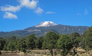
Tzompantepec is a town and its surrounding municipality located in the eastern portion of the Mexican state of Tlaxcala. It is located in the Central Mexican Plateau, almost entirely on the slopes of the La Malinche Volcano. The area was the earliest to be inhabited in Tlaxcala and it was also the site of the defeat of the Tlaxcallans in the early part of the Spanish Conquest. The municipality is mostly farmland but urban sprawl has limited both natural vegetation and wildlife.
Most Mexican states do not have an official flag. For these states, a de facto flag is used for civil and state purposes. State flags of Mexico have a 4:7 ratio and typically consist of a white background charged with the state's coat of arms.
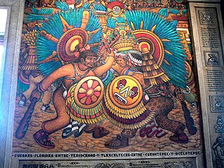
Desiderio Hernández Xochitiotzin was a Mexican artist best known for his large-scale mural work inside the State Government Palace in the state of Tlaxcala, Mexico, the last large scale mural of the Mexican muralism movement.
Zacatelco is a city and municipal seat of the Zacatelco municipality located in the south of the Mexican state of Tlaxcala. According to the 2010 population census conducted by the National Institute of Statistics and Geography, the city has a population of 38,466 people, it is the sixth most populous city in the state and is part of the Metropolitan area of Puebla. The city is also head of the third electoral district of Tlaxcala.
Ixtenco is located in Ixtenco Municipality in the southeast of the Mexican state of Tlaxcala. It is a traditional Otomi community, which has conserved its agricultural economic base and various traditions. However, it is one of the poorest and least populated of the state's municipalities. The town's main landmark is the San Juan Bautista Parish and the municipality contains the remains of colonial era haciendas. The municipality lies on an old lava flow from the nearby La Malinche Volcano, which provides its volcanic soil, but because of the destruction of forests and overgrazing, erosion is a significant problem.

Tlaxco is a town and its surrounding municipality in the Mexican state of Tlaxcala.