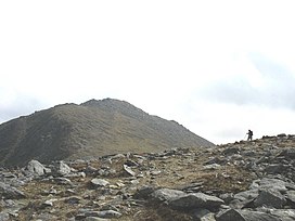
Carnedd Llewelyn, more correctly spelt Carnedd Llywelyn in Welsh, is a mountain massif in the Carneddau range in Snowdonia, north-west Wales. It is the highest point of the Carneddau and the second highest peak by relative height in Wales, 49th in the British Isles and lies on the border between Gwynedd and Conwy.
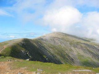
Carnedd Dafydd is a mountain peak in the Carneddau range in Snowdonia, North Wales, and is the third highest peak in Wales, or the fourth if Crib y Ddysgl on the Snowdon ridge is counted. Situated south-west of Carnedd Llewelyn and north of Pen yr Ole Wen, Carnedd Dafydd is on the main ridge of the Carneddau, and on the border between Gwynedd and Conwy. The average annual temperature of the mountain is around 3–4 °C.

Foel-fras (944 m) is a mountain in the Carneddau range, about 10 km east of Bethesda in North Wales. It lies on the border between the counties of Gwynedd and Conwy. With a summit elevation of 944 m it is officially the eleventh-highest summit in Wales. Foel-fras is located at the northern end of the main ridge of the Carneddau, between Drum to the north and Foel Grach to the south, with the subsidiary summit of Garnedd Uchaf (925 m) between it and Foel Grach. Due south and 400 m below lies the reservoir of Llyn Dulyn, while the smaller reservoir of Llyn Anafon lies to the north.

Pen Llithrig y Wrach is a mountain peak in Snowdonia, North Wales. It is one of the four Marilyns that make up the Carneddau range. To the east is Creigiau Gleision, another Marilyn, while to the west is Pen yr Helgi Du and Carnedd Llewelyn. Craig Eigiau and Llyn Eigiau can be seen to the north, while Gallt yr Ogof, Glyder Fach and Tryfan can be viewed to the south.

Foel Grach is a mountain in the Carneddau range. It is the eighth-highest summit in Snowdonia as well as Wales, and is included in the Welsh 3000s.

Carnedd Gwenllian is a minor summit of the Carneddau range in Snowdonia, Wales, and included in the Welsh 3000s. From the summit, distant views to the north can extend as far as Ireland and the Isle of Man, and to the South as far as the Berwyn Ranges.

Tal y Fan is an outlying peak of the Carneddau mountains in North Wales. It is one of the four Marilyns that make up the Carneddau, the others being Carnedd Llywelyn, Pen Llithrig y Wrach and Creigiau Gleision.

Drum is a summit in the Carneddau mountains in north Wales, 2 km north-east of Foel-fras. It is 771 m (2,526 ft) high. It is also known as Carnedd Penyborth-Goch.

Foel Meirch is a top of Carnedd Dafydd in the Carneddau range in Snowdonia, North Wales. It offers commanding views of Carnedd Llewelyn and Yr Elen, and the Ysgolion Duon Cliffs.

Carnedd y Ddelw is a summit in the Carneddau mountains in north Wales, north-east of Foel-fras. It is the Nuttall top of Drum (Wales). Its eastern slopes are drained by the Afon Tafolog, a tributary of Afon Roe that flows through the village of Rowen before joining the River Conwy. It is also the final top on Carnedd Llewelyn's long northern spur. To the north-west is Tal y Fan, the most northerly 2000 foot tall mountain in the Carneddau and Wales. The summit has two large shelter cairns, hollowed out from a large Bronze Age burial cairn.

Y Drosgl is a summit of the Carneddau range in Snowdonia, Wales, and forms a part of the western Carneddau, also known as the Berau, meaning 'stacks' or 'ricks'. It lies on a ridge heading west from Carnedd Gwenllian and Bera Mawr towards Bethesda. A large ancient burial cairn, dating from the Bronze Age, adorns the summit, from where good views of Cwm Caseg and the Menai can be seen.

Bera Mawr is a summit in the Carneddau mountains in north Wales, height 794 metres. It and Bera Bach are together known as the Berau, or northern Carneddau. The summit is a large rock tor, characteristic of the western Carneddau. There are views of Llwytmor and Foel-fras to the north-east, Garnedd Uchaf to the south-east, Bera Bach to the south, Drosgl to the west and the Menai to the north-west.

Castell y Gwynt is a top of Glyder Fach in Snowdonia, north-west Wales. It has the merit of being the only 3000 ft Welsh summit classed as only a Nuttall, hence it is not included in the Welsh 3000s. It has a prominence of 15.7 m (51.5 ft), and was only included on the Nuttall's list after re-surveying in 2007. The top is more famous as a feature than a summit.

Carnedd y Filiast is a mountain in Snowdonia, Wales, forming part of the Glyderau. It, along with its top Y Fronllwyd, forms the most northerly summit in the Glyderau. The average annual temperature on Carnedd y Filiast is estimated to be around 4 Celsius.

Carnedd y Filiast is a mountain near Cerrigydrudion on the border of the Snowdonia National Park, North Wales and is 669 metres (2,195 ft) high.

Arenig Fach is a mountain in southern Snowdonia, north Wales. It is a peak in the Arenig range and lies to the north of its parent peak Arenig Fawr.

Foel Goch is a mountain in north-east Wales, and forms part of the Arenig mountain range. It is the only member of the Arenig group that lies outside of the Snowdonia National Park.

Carnedd Llechwedd-llyfn is a subsidiary summit of Carnedd y Filiast on the border of Snowdonia National Park in Llandderfel, in Gwynedd. The northern slopes of the peak lie in Ysbyty Ifan, in Conwy. It is part of the Arenig mountain range, and rises from the shore of Llyn Celyn.

Waun Garnedd-y-filiast is a top of Carnedd y Filiast on the border of the Snowdonia National park near Cerrigydrudion in North Wales. It is part of the Arenig mountain range. It is also a peak in an area of moorland known as the Migneint.

Y Gamallt is a mountain located in the Migneint in Snowdonia, North Wales. It forms part of the Arenig mountain range being separated from the Moelwynion range at the head of Cwm Teigl.