Yabo, Nigeria

Last updated

Yabo
LGA and town
Nickname: 
Yabo Garin Moyijo
Nigeria location map.svg
Red pog.svg
Yabo
Coordinates: 12°43.15′N5°00.37′E / 12.71917°N 5.00617°E / 12.71917; 5.00617
CountryFlag of Nigeria.svg  Nigeria
State Sokoto State
Government
  Executive ChairmanHaliru Abubakar Kilgori
  Member State House of AssemblyHon. Abubakar Shamaki Yabo
  Sarkin KabiMuhammadu Maiturare II
Area
  Total789 km2 (305 sq mi)
Population
 (2006)
  Total115,011
Time zone UTC+1 (WAT)
3-digit postal code prefix
851
ISO 3166 code NG.SO.YA
Yabo, Nigeria

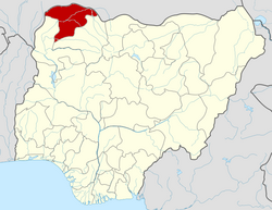
Yabo is a Local Government Area in Sokoto State, Nigeria. Its headquarters is in the town of Yabo, and Yabo local Government is one of the oldest local governments in Sokoto. Since Sokoto, Kebbi and Zamfara are known as Sokoto. by then Yabo, Tambuwal and Shagari are all known as Yabo local government.

Contents

It has an area of 789 km2 (305 sq mi) and a population of 115,011 at the 2006 census. [1]

The postal code of the area is 851. [2]

History

The people of Yabo under the leadership of their king and scholar, Muhammadu Moyijo played a pivotal role towards Islamic teaching, reformation and establishment of Sokoto Caliphate led by Sheik Uthman Bn Fodiyo. Moyijo was a close friend, companion and supporter of Sheik Uthman Bn Fodio. He accompanied Sheik in several of his Islamic outings and spread his teaching around his localities. On his way to Zamfara, Shehu met Moyijo at a village called Magali where they discussed important issues related to Islam and calling people towards Islam. Their meeting point is historically marked and even today the acclaimed Sheik Fodiyo's well and a tree under which Sheik Fodiyo teaches his followers still exist in Magabcci. In view of his vast knowledge in both Islamic teachings, administration and defence, Moyijo was appointed as the leader as well as the Flag bearer in-charge of Kebbi. [3]

Climate

The climate has two distinct seasons: a scorching, oppressive rainy season with predominantly cloudy skies, and a scorching, partly cloudy dry season with temperatures ranging from 62°F to 103°F. [4]

Related Research Articles

<span class="mw-page-title-main">Sokoto</span> Capital city of Sokoto State, Nigeria

Sokoto is a major city located in extreme north-western Nigeria, near the confluence of the Sokoto River and the Rima River. As of 2006, it has a population of over 427,760. Sokoto is the modern-day capital of Sokoto State and was previously the capital of the north-western states. Modern Sokoto is known for trading sheepskins, cattle hides, leather crafts, kola nuts and goatskins.

Kebbe is a Local Government Area in Sokoto State, Nigeria. Its headquarters are in the town of Kebbe. The LGA shares a border with Zamfara State in the east and Kebbi State in the south and west.

<span class="mw-page-title-main">Sokoto State</span> State of Nigeria

SokotoState is one of the 36 states of Nigeria, located in the extreme northwest of the country. Bounded by Republic of the Niger to the north and west for 363 km, and the states of Zamfara to the east, and Kebbi to the south and west, partly across the Ka River. Its capital and largest city is the city of Sokoto. Sokoto is located near to the confluence of the Sokoto River and the Rima River. As of 2022 it has an estimated population of more than 6.3 million.

<span class="mw-page-title-main">Gusau</span> Capital city of Zamfara State, Nigeria

The city of Gusau, located in northwestern Nigeria, is the capital of Zamfara State. It is also the name of the state's Local Government Area (LGA), which has an area of 3,364 km (2,090 mi)² and a population of 383,162 as of the 2006 census.

Gwandu, also called Gando, is a town and emirate in Kebbi State, Nigeria. The seat of government for the emirate and district of this name is in Birnin Kebbi, which is the capital of Kebbi State and was capital of the historical Kingdom of Kebbi. Founded in the sixteenth century by the Kabbawa, a Hausa people Gwandu today acts as one of the four emirates composing Kebbi State.

<span class="mw-page-title-main">Birnin Kebbi</span> Capital city of Kebbi State, Nigeria

Birnin Kebbi is a city located in Northwestern Nigeria It is the capital city of Kebbi State and headquarter of the Gwandu Emirate. As at 2007 the city had an estimated population of 125,594 people. Kebbi is mostly a Hausa and Fulani state, with Islam as the major religion. Formerly it was the capital of the Kebbi Emirate, which relocated to Argungu after the conquest by Gwandu in 1831. The town remained the capital of Kebbi until 1805, when it was burned in the Fulani jihad by Abdullahi dan Fodio, a brother of the jihad leader and later Emir of Gwandu. After Birnin Kebbi was incorporated into the Fulani Emirate of Gwandu, it was eclipsed in political importance by Gwandu (Gando) town, 30 miles (48 km) east, and as a caravan and riverside market centre by Jega, 20 miles (32 km) southeast, which lay at the head of navigation on the Zamfara River, a tributary of the Sokoto. Ironically, while Argungu became the traditional seat of the king of Kebbi in 1827, Birnin Kebbi served as the Gwandu emirate headquarters after Emir Haliru was inaugurated there in 1906. Birnin Kebbi became the capital of the newly created Nigerian state of Kebbi in 1991.

Mallam Abdullahi ɗan Fodio, a prominent Islamic scholar, jurist, poet and theologian, was the first Amir of Gwandu and first Grand Vizier of Sokoto. His brother, Usman dan Fodio (1754–1817) was the founder of the Sokoto Caliphate. Usman, being more of a scholar than politician, delegated the practical regency of the western part of his empire to Abdullahi and the eastern part to his son Muhammed Bello, who later became the Sultan of Sokoto after his father.

Jibia is a town and Local Government Area (LGA) in Katsina State, northern Nigeria. The population of the LGA was approximately 125,000 as of 2003, and the area is 1037 km2.

Kiyawa is a town and local government area in Jigawa State, Nigeria.

Gummi is a Local Government Area in Zamfara State, Nigeria. Its headquarters is in the town of Gummi at12°08′30″N5°07′30″E .

Augie is a Local Government Area in Kebbi State, Nigeria. Its headquarters are in the town of Augie.

Aleiro is a Local Government Area in Kebbi State, Nigeria. Its headquarters are in the town of Aliero.

Anka is a Local Government Area in Zamfara State, Nigeria. Its headquarters is in the town of Anka at 12°06′30″N5°56′00″E.

Shinkafi is a Local Government Area in Zamfara State of Nigeria. Its headquarters is in the town of Shinkafi an area of about 674mk2 and population of 135,649. It shares boundaries with Isa Local Government Area and Niger Republic from the north, Zurmi Local Government Area to the South and South-East, Maradun Local Government Area and Raba Local Government Area by the west. Distance from the State Capital, Gusau is approximately 116 km.

Bakura is a Local Government Area in Zamfara State, Nigeria. Its headquarters are in the town of Bakura at12°42′37″N5°52′23″E in the north-east of the Local government area.Wind

Wurno is a Local Government Area in Sokoto State, Nigeria. Its headquarters is in the town of Wurno, near the Gagere River.

Shagari is a Local Government Area in Sokoto State, Nigeria. Its headquarters are in the town of Shagari on the A1 highway. The local government area (LGA) shares a border with Zamfara State in the south.

Tureta is a Local Government Area in Sokoto State, Nigeria. Its headquarters is in the town of Tureta. It shares a border with Zamfara State in the south and east. They are mainly Hausa people predominantly Burmawa. Islam is there main religion. Fishing and farming are the major occupations. Currently Dr Muhammad Danrabi Tureta is their newly appointed king title as sarkin Burmin tureta.

Binji is a Local Government Area in Sokoto State, Nigeria. Its headquarters are in the town of Binji. It was originally established by the sons of the military commander Ali Jedo as a Ribat.

Ali Jedo, was the first Amir al-jaish al-Islam of the Sokoto Caliphate. Prior to the jihad, he was the leader of the Fulbe of Konni in modern-day Sokoto State.

References

  1. HASC, population, area and Headquarters Statoids
  2. "Post Offices- with map of LGA". NIPOST. Retrieved 2009-10-20.
  3. Smaldone, Joseph P (1977). "Ch 2: The Jihad Period, c. 1790–1817". In John Dunn; J. M. Lonsdale; David M. G. Newbery; A. F. Robertson (eds.). Warfare in the Sokoto Caliphate: Historical and Sociological Perspectives . CAMBRIDGE: Cambridge University Press. p.  26. ISBN   978-0-521-21069-0.{{cite book}}: |work= ignored (help)
  4. "Yabo Climate, Weather By Month, Average Temperature (Nigeria) - Weather Spark". weatherspark.com. Retrieved 2023-09-01.