| Yansa Tsenji | |
|---|---|
| Dhagpache | |
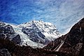
 Southeast aspect | |
| Highest point | |
| Elevation | 6,567 m (21,545 ft) [1] [2] |
| Prominence | 475 m (1,558 ft) [1] |
| Parent peak | Shalbachum [1] |
| Isolation | 2.73 km (1.70 mi) [1] |
| Coordinates | 28°15′23″N85°36′18″E / 28.256516°N 85.605054°E [1] |
| Geography | |
 Yansa Tsenji Location in Nepal 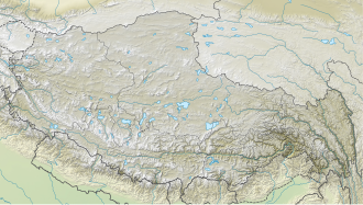 Yansa Tsenji Yansa Tsenji (Tibet)  Yansa Tsenji Yansa Tsenji (China) | |
 | |
| Interactive map of Yansa Tsenji | |
| Location | China–Nepal border |
| Countries | Nepal and China |
| Province | Bagmati |
| District | Rasuwa |
| Protected area | Langtang National Park Qomolangma National Nature Preserve |
| Parent range | Himalayas Langtang Himal [3] |
| Climbing | |
| First ascent | 2023 |
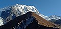
Yansa Tsenji, also known as Dhagpache, [3] is a mountain in Nepal and Tibet.