In the United States, a metropolitan statistical area (MSA) is a geographical region with a relatively high population density at its core and close economic ties throughout the region. Such regions are not legally incorporated as a city or town would be and are not legal administrative divisions like counties or separate entities such as states. As a result, sometimes the precise definition of a given metropolitan area will vary between sources. The statistical criteria for a standard metropolitan area were defined in 1949 and redefined as a metropolitan statistical area in 1983.

Bloomington–Normal, officially known as the Bloomington, Illinois Metropolitan Statistical Area, is a metropolitan statistical area in Central Illinois anchored by the twin municipalities of Bloomington and Normal. At the 2010 census, the municipalities had a combined urban population of 132,600, while the metropolitan area had a population of 169,572.
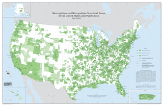
United States micropolitan statistical areas, as defined by the Office of Management and Budget (OMB), are labor market and statistical areas in the United States centered on an urban cluster with a population of at least 10,000 but fewer than 50,000 people. The micropolitan area designation was created in 2003. Like the better-known metropolitan statistical areas, a micropolitan area is a geographic entity used for statistical purposes based on counties and county equivalents. On July 21, 2023, the Office of Management and Budget released revised delineations of the various CBSAs in the United States, which recognized 542 micropolitan areas in the United States, four of which are in Puerto Rico.
Combined statistical area (CSA) is a United States Office of Management and Budget (OMB) term for a combination of adjacent metropolitan (MSA) and micropolitan statistical areas (μSA) across the 50 U.S. states and the territory of Puerto Rico that can demonstrate economic or social linkage. CSAs were first designated in 2003. OMB defines a CSA by various combinations of adjacent metropolitan and micropolitan areas with economic ties measured by commuting patterns. CSAs retain their own designations as metropolitan or micropolitan statistical areas in their respective larger combined statistical areas.

The Sarasota metropolitan area is a metropolitan area located in Southwest Florida. The metropolitan area is defined by the Office of Management and Budget (OMB) as the North Port–Bradenton–Sarasota Metropolitan Statistical Area, a metropolitan statistical area (MSA) consisting of Manatee County and Sarasota County. The principal cities listed by the OMB for the MSA are North Port, Bradenton, Sarasota, Lakewood Ranch, and Venice. At the 2020 census, the MSA had a population of 833,716. The Census Bureau estimates that its population was 891,411 in 2022.
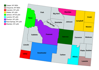
The U.S. State of Wyoming currently has ten statistical areas that have been delineated by the Office of Management and Budget (OMB). On July 21, 2023, the OMB delineated two metropolitan statistical areas and eight micropolitan statistical areas in Wyoming. The most populous of these statistical areas is the Cheyenne, WY Metropolitan Statistical Area with a 2020 Census population of 100,512.
The Commonwealth of Puerto Rico currently has 15 statistical areas that have been delineated by the United States Office of Management and Budget (OMB). On March 6, 2020, the OMB delineated three combined statistical areas, eight metropolitan statistical areas, and four micropolitan statistical areas in Puerto Rico.

The Manhattan–Junction City Combined Statistical Area, as defined by the United States Census Bureau, is an area consisting of three counties in northeastern Kansas, anchored by the city of Manhattan. It was upgraded from a Micropolitan Statistical Area (μSA) to a Metropolitan Statistical Area (MSA) by the Office of Management and Budget on November 20, 2008. It was changed from a Metropolitan Statistical Area (MSA) to a Combined Statistical Area (CSA) by the Office of Management and Budget on February 28, 2013.

The Cape Girardeau–Jackson Metropolitan Statistical Area, as defined by the United States Census Bureau, is an area consisting of two counties in southeastern Missouri and one in southern Illinois with its core in both states. Its largest cities are the cities of Cape Girardeau and Jackson. It was upgraded from a Micropolitan Statistical Area (μSA) to a Metropolitan Statistical Area (MSA) by the Office of Management and Budget on November 20, 2008.
The Jasper micropolitan statistical area, as defined by the United States Census Bureau, is an area consisting of one county in southwestern Indiana, anchored by the city of Jasper. At the 2020 census, the Micropolitan area (μSA) had a population of 43,637 up from a population of 41,889 in the 2010 census. In previous statistical definition updates, the area also included Pike County which was removed in the 2023 updates.

The Aguadilla metropolitan area is a United States Census Bureau defined metropolitan statistical area (MSA) in northwestern Puerto Rico. According to the 2009 Census Bureau estimate, The area has the total population at 342,495, a 9.56% increase over the 2000 census figure of 312,602.
The Fajardo Metropolitan Statistical Area was a United States Census Bureau defined Metropolitan Statistical Area (MSA) in northeastern Puerto Rico. A July 1, 2009 Census Bureau estimate placed the population at 80,707, a 2.77% increase over the 2000 census figure of 78,533.
The Guayama Metropolitan Statistical Area is a United States Census Bureau defined Metropolitan Statistical Area (MSA) in southeastern Puerto Rico. As of the 2023 metropolitan area definitions, the Guayama metropolitan area has been included as a component of the San Juan–Bayamón, PR Combined Statistical Area. 2020 Census results placed the population at 68,442, an 18.73% decrease over the 2010 Census. 2010 Census results placed the population at 84,214, a 0.83% increase over the 2000 census figure of 83,570.
The Mayagüez Metropolitan Statistical Area is a United States Census Bureau defined Metropolitan Statistical Area (MSA) in west central Puerto Rico. A July 1, 2009 Census Bureau estimate placed the population at 109,842, a 4.53% decrease from the 2000 census figure of 115,048.

The San Juan metropolitan area is a United States Census Bureau defined metropolitan statistical area (MSA) in northeastern Puerto Rico centered around the city of San Juan. A July 1, 2009, Census Bureau estimate placed the population at 2,617,089, a 4.31% increase over the 2000 census figure of 2,509,007.
The San Germán–Cabo Rojo Metropolitan Statistical Area was a United States Census Bureau defined Metropolitan Statistical Area (MSA) in southwestern Puerto Rico. A July 1, 2009 Census Bureau estimate placed the population at 148,559, a 9.06% increase over the 2000 census figure of 136,212.
The Ponce Metropolitan Statistical Area is a United States Census Bureau defined Metropolitan Statistical Area (MSA) in south central Puerto Rico. A 1 July 2009 Census Bureau estimate placed the population at 262,414, a 0.95% decrease from the 2000 census figure of 264,919.
The Kokomo Metropolitan Statistical Area, as defined by the United States Census Bureau, is an area consisting of Howard County in Indiana. Howard County had a population estimate of 83,831 in 2023. Kokomo is also the principal city of the area known as North Central Indiana, the area around Kokomo with economic ties. The six county area including Cass, Clinton, Fulton, Howard, Miami, and Tipton counties had population of 228,331 people in 2010.
The United States federal government defines and delineates the nation's metropolitan areas for statistical purposes, using a set of standard statistical area definitions. As of 2023, the U.S. Office of Management and Budget (OMB) defined and delineated 393 metropolitan statistical areas (MSAs) and 542 micropolitan statistical areas (μSAs) in the United States and Puerto Rico. Many of these 935 MSAs and μSAs are, in turn, components of larger combined statistical areas (CSAs) consisting of adjacent MSAs and μSAs that are linked by commuting ties; as of 2023, 582 metropolitan and micropolitan areas are components of the 184 defined CSAs. A collective term for MSAs, μSAs, and CSAs is primary statistical areas (PSAs), though that term is not used by OMB.
