
Kentucky, officially the Commonwealth of Kentucky, is a state in the Southeastern region of the United States and one of the states of the Upper South. It borders Illinois, Indiana, and Ohio to the north, West Virginia to the northeast, Virginia to the east, Tennessee to the south, and Missouri to the west. Its northern border is defined by the Ohio River. Its capital is Frankfort, and its two largest cities are Louisville and Lexington. Its population was approximately 4.5 million in 2020.

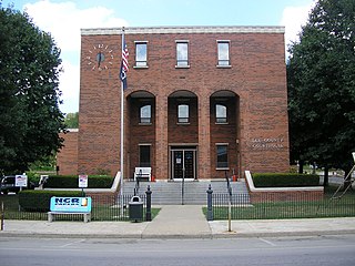
Clay County is a county located in the U.S. state of Kentucky. As of the 2020 census, the county population was 20,345. Its county seat is Manchester. The county was formed in 1807 and named in honor of Green Clay (1757–1826). Clay was a member of the Virginia and Kentucky State legislatures, first cousin once removed of Henry Clay, U.S. Senator from Kentucky and Secretary of State in the 19th century.

A natural arch, natural bridge, or rock arch is a natural landform where an arch has formed with an opening underneath. Natural arches commonly form where inland cliffs, coastal cliffs, fins or stacks are subject to erosion from the sea, rivers or weathering.
Lee County is a county located in the U.S. state of Kentucky. As of the 2020 census, the population was 7,395. Its county seat is Beattyville. The county was formed in 1870 from parts of Breathitt, Estill, Owsley and Wolfe counties. The county was named for Robert E. Lee. The area of Kentucky where Lee County is located was a pro-union region of Kentucky but the legislature that created the county was controlled by former Confederates. The town of Proctor, named for the Rev. Joseph Proctor, was the first county seat. The first court was held on April 25, 1870, in the old Howerton House. The local economy at the time included coal mining, salt gathering, timber operations, and various commercial operations. It had a U.S. post office from 1843 until 1918.
The Music of Kentucky is heavily centered on Appalachian folk music and its descendants, especially in eastern Kentucky. Bluegrass music is of particular regional importance; Bill Monroe, "the father of bluegrass music", was born in the Ohio County community of Rosine, and he named his band, the Blue Grass Boys, after the bluegrass state, i.e., Kentucky. Travis picking, the influential guitar style, is named after Merle Travis, born and raised in Muhlenberg County. Kentucky is home to the Country Music Highway, which extends from Portsmouth, Ohio, to the Virginia border in Pike County.

The Falls of the Ohio National Wildlife Conservation Area is a national, bi-state area on the Ohio River near Louisville, Kentucky in the United States, administered by the U.S. Army Corps of Engineers. Federal status was awarded in 1981. The falls were designated a National Natural Landmark in 1966.
The Middlesboro crater is a meteorite crater in Kentucky, United States. It is named after the city of Middlesborough, which today occupies much of the crater.

Luke Pryor Blackburn was an American physician, philanthropist, and politician from Kentucky. He was elected the 28th governor of Kentucky, serving from 1879 to 1883. Until the election of Ernie Fletcher in 2003, Blackburn was the only physician to serve as governor of Kentucky.

The Kentucky warbler is a small species of New World warbler. It is a sluggish and heavy warbler with a short tail, preferring to spend most of its time on or near the ground, except when singing.

The Big South Fork National River and Recreation Area, commonly known as Big South Fork, preserves the Big South Fork of the Cumberland River and its tributaries in northeastern Tennessee and southeastern Kentucky.

Natural Bridge State Resort Park is a Kentucky state park located in Powell and Wolfe Counties along the Middle Fork of the Red River, adjacent to the Red River Gorge Geologic Area and surrounded by the Daniel Boone National Forest. Its namesake natural bridge is the centerpiece of the park. The natural sandstone arch spans 78 ft (24 m) and is 65 ft (20 m) high. The natural process of weathering formed the arch over millions of years. The park is approximately 2,300 acres (9 km2) of which approximately 1,200 acres (5 km2) is dedicated by the Office of Kentucky Nature Preserves as a nature preserve. In 1981 this land was dedicated into the nature preserves system to protect the ecological communities and rare species habitat. The first federally endangered Virginia big eared bats, Corynorhinus townsendii virginianus, recorded in Kentucky were found at Natural Bridge State Resort Park in the 1950s.
Kingdom Come State Park is a part of Kentucky's state park system in Harlan County atop Pine Mountain near the city of Cumberland. It was named after the 1903 best-selling novel The Little Shepherd of Kingdom Come by native Kentuckian John Fox, Jr. Features of the park include Raven Rock, Log Rock, and a 3.5-acre (1.4 ha) mountain lake. The section of the park is also a legally dedicated state nature preserve by the Office of Kentucky Nature Preserves.
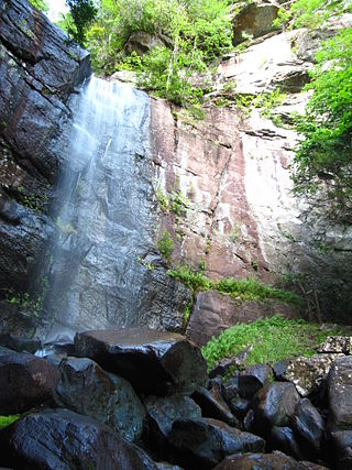
Bad Branch Falls State Nature Preserve is a forested gorge covering 2,639 acres near Whitesburg, KY in Letcher County, Kentucky. The deep and narrow gorge, adjacent to the Jefferson National Forest is carved into the face of Pine Mountain. Sandstone boulders and cliffs along with riglines and knobs provide views into the Appalachia area. The terrain is landscaped with streams, rivers, and a 60-foot waterfall. With a variety of habitat types, this nature preserve is home to many unique and unknown species of flora and fauna.
Black and White Taxicab and Transfer Company v. Brown and Yellow Taxicab and Transfer Company, 276 U.S. 518 (1928), was a United States Supreme Court case in which the Court refused to hold that federal courts sitting in diversity jurisdiction must apply state common law. Ten years later, in Erie Railroad Co. v. Tompkins, the Court reversed course, and overturned Swift v. Tyson.
The Huntington–Ashland metropolitan area is a metropolitan area in the Appalachian Plateau region of the United States. Referred to locally as the “Tri-State area”, and colloquially as "Kyova", the region spans seven counties in the three states of Kentucky, Ohio, and West Virginia. With a population of 361,580, the Tri-State area is nestled along the banks of the Ohio River. The region offers a diverse range of outdoor activities.
Yellow Rock may refer to:
Yelvington is a small unincorporated community in the U.S. state of Kentucky, located approximately 12 miles east of Owensboro along U.S. Route 60 east and near the Daviess-Hancock county line.
The 1891 Kentucky State College Blue and Yellow football team represented Kentucky State College—now known as the University of Kentucky—as an independent during the 1891 college football season. The 1891 team's colors were blue and light yellow, decided before the Centre–Kentucky game on December 19. A student asked "What color blue?" and varsity letterman Richard C. Stoll pulled off his necktie, and held it up. This is still held as the origin of Kentucky's shade of blue. The next year light yellow was dropped and changed to white.
The 2016 TaxSlayer Bowl was a post-season American college football bowl game played on December 31, 2016, at EverBank Field in Jacksonville, Florida. The 72nd edition of the Gator Bowl featured the Georgia Tech Yellow Jackets of the Atlantic Coast Conference against the Kentucky Wildcats of the Southeastern Conference. It began at 11 AM EST and aired on ESPN. It was one of the 2016–17 bowl games concluding the 2016 FBS football season. The game's naming rights sponsor was tax preparation software company TaxSlayer.com, and for sponsorship reasons was officially known as the TaxSlayer Bowl.


