
The Tungabhadra River starts and flows through the state of Karnataka, India, during most of its course, then through Andhra Pradesh, and ultimately joins the Krishna River near Murvakonda in Andhra Pradesh.

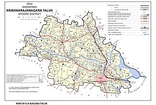
Tirumakudalu Narasipura the temple city of Karnataka, commonly known as T. Narasipura or T.N. Pura, is a town in Mysore district in the Indian state of Karnataka. The first name refers to the land at the confluence, (trimakuta in Sanskrit at the confluence of the Kaveri, Kabini and Spatika Sarovara. The city is a Taluk of Mysore district and 32 km south-east of the district headquarters and has five Hobli centers. This taluk is bordered by Chamarajanagar district to the south and Mandya districts to the north with an area of 598 sq km. Agriculture is the main occupation of the people here. Rice is the main food crop and silk is the main commercial crop. Fossils of Neolithic age have been found by excavation in some lands of this Taluk. Vyasatirtha, the guru of Purandara Dasa, and T Chowdiah, the unique violinist, were born in this Taluk. Talakad, the capital of the Western Ganga dynasty, is in this Taluk.

Ganagapura is a village in Karnataka, India, in the Afzalpur taluk of Kalaburagi district in Karnataka. It has a temple to Lord Dattatreya.
Bandri is a village in the southern state of Karnataka, India. It is located in the Sandur taluk of Bellary district in Karnataka.
Chornur is a village in the southern state of Karnataka, India. It is located in the Sandur taluk of Bellary district in Karnataka.
Daroji is a village in the southern state of Karnataka, India. It is located in the Sandur taluk of Bellary district in Karnataka.
Kurekuppa is a village in the southern state of Karnataka, India. It is located in the Sandur taluk of Bellary district in Karnataka.

Kurugodu is a town in the southern state of Karnataka, India. It is headquarters of Kurugodu taluk in Bellary district of Karnataka. The Sri Dodda Basaveshwara Temple is located here. Every year Ratha Mahothsava of the Swamy Dodda Basaveshwara held on holy Poornima.
Moregeri is a village in the southern state of Karnataka, India. It is located in the Hagaribommanahalli taluk of Vijayanagara district in Karnataka.
Siddammanahalli is a village in the southern state of Karnataka, India. It is located in the Ballari taluk of the Ballari district.
Toranagallu, or Torangal, is a village in the southern state of Karnataka, India. It is located in the Sandur taluk of Ballari district in Karnataka.
Vaddu is a village in the southern state of Karnataka, India. It is located in the Sandur taluk of Bellary district in Karnataka.
Ramapura is a village in the southern state of Karnataka, India. It is located in the Hanur taluk of Chamarajanagar district in Karnataka.It is surrounded by Ajjipura, Cowdhalli, Martalli, Hoogya, Kudlur, Ponnachi and Male Mahadeshwara Betta. As per Indian Postal Department, the name of this place is Ramapuram Ghat. Ramapura is very close to the border of Tamil Nadu. It was part of erstwhile Tamil Nadu state. Ramapura is closely surrounded by three more villages viz., Poojaribhovidoddi, Gopishettiyur, Gejjalanatta and Muttushettiyur. Chengadarahalli, Puduramapuram, Palanimedu are other small villages. The Postal PIN code is 571444.
Towdur is a village in the southern state of Karnataka, India. It can also be spelt as Thoudur, Tavadur or Thouduru. It is located in the Harapanahalli taluk of Bellary district in Karnataka. It is a Grama Panchayat, consisting of 11 villages. The village has mostly farmers, a few middle-class families, and very few rich people. The village consists of 7 main historical temples. Udisalambika Devi Temple and Veeranjaneya temples are the famous among them. Basavanna Temple is like an assembly for the villagers. Villagers assemble here for Important discussions in the name of Panchayat meet. Thoudur owns 1 Government Higher Primary School and Government High school named Ayyanahalli Matada Kadamma Veerayya High School land donated by AM Ajjaiah & Kotraiah brothers on remembrance of his Parents.

Hedathale is a village in the southern state of Karnataka, India. It is located in the Nanjangud taluk of Mysore district in Karnataka. It is a divine and unique Hindu religious centre.
55 Mallapura is a village in the southern state of Karnataka, India. It is located in the Sandur taluk of Bellary district in Karnataka.
Saligrama is a new sub-district of Mysore district, situated on the northern bank of the river Cauvery [Kaveri]. This place is esteemed as sacred by the Shri Vaishnavas on account of its having been the residence of Sri Ramanujacharya. It is the headquarters of Saligrama Taluk. It was established as a new taluk carving out of K.R.Nagar taluk with effect from 31.12.2020 and become ninth taluk of Mysore district of Karnataka, India.
Kenchanagudda is a village in the southern state of Karnataka, India. The village is located in the Siruguppa taluk of Ballari district.
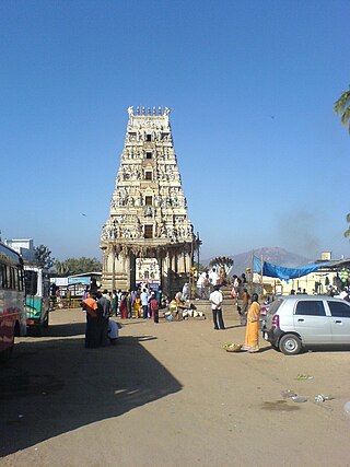
Ghati Subramanya is a Hindu temple, situated in the village of Sri Subamanya Ghati near Tubagere, Doddaballapura, Karnataka, India. It is 60 km from the city of Bangalore and is a popular pilgrimage centre. The uniqueness of this temple is that the prime deity Lord Karthikeya, is found together with Lord Narasimha. According to mythology, both idols are believed to have emerged from the earth. It is also an important centre in South India for worship of the Hindu deity Kethu. Special rituals are performed during Brahmarathotsava on the day of Pushya shudda Shashti. Narasimha Jayanti is the other major festival celebrated here.

Vijayanagara district is a district in the southern Indian state of Karnataka, located in the Kalyana-Karnataka region.

