
Madhya Pradesh is a state in central India. Its capital is Bhopal, and the largest city is Indore, with Gwalior, Jabalpur, Ujjain, Dewas, Sagar, and Rewa being the other major cities. Madhya Pradesh is the second largest Indian state by area and the fifth largest state by population with over 72 million residents. It borders the states of Uttar Pradesh to the northeast, Chhattisgarh to the east, Maharashtra to the south, Gujarat to the west, and Rajasthan to the northwest.

Pachmarhi is a hill station in the Hoshangabad district of Madhya Pradesh state of central India. It has been the location of a cantonment since the British Raj. The municipality is located in a valley of the Satpura Range and is widely known as Satpura ki Rani.
Barwani or Badwani is a municipal town in Barwani district of Madhya Pradesh, India, that is situated near the left bank of the Narmada River. It is the administrative headquarters of Barwani district and has also served as the capital of the former princely state of Barwani. Barwani is only accessible by road.

Hoshangabad, officially Narmadapuram, is a city in the Indian state of Madhya Pradesh. It serves as the headquarters of both Hoshangabad district and Narmadapuram division. It is located in central India, on the south bank of the Narmada River. Hoshangabad is 76.7 km (47.7 mi) from the capital of Madhya Pradesh and the nearest airport Bhopal.
Harda is a city and a municipality in Harda district in the Indian state of Madhya Pradesh. Harda is the administrative headquarters of Harda.
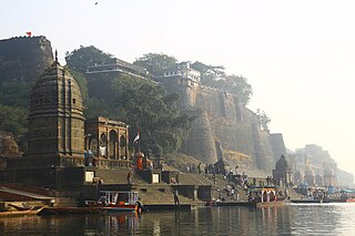
Maheshwar is a town, near Khargone city in Khargone district of Madhya Pradesh state, in central India. It is located on State Highway-38 ,13.5 km east of National Highway 3 and 91 km from Indore, the commercial capital of the state. The Town lies on the north bank of the Narmada River. It was the kingdom of Chaktavartin Samrat Sahastraarjun, Kartavirya Arjuna a Heheya king. Lately, after many years, it was the capital of the Malwa during the Maratha Holkar reign till 6 January 1818, when the capital was shifted to Indore by Malhar Rao Holkar III.

Hoshangabad district, officially Narmadapuram district, is one of the districts of Madhya Pradesh state of India, and Hoshangabad city is the district headquarters.
Surajpur is a Nagar Palika Parishad situated in the bank of Rihand River in Surajpur district of Chhattisgarh state in Central India. It is the administrative headquarters of the Surajpur district, located 334 km away from the state's capital city, Raipur. National Highway 43 passes through Surajpur.

Budhni, also spelled Budni or Budhani, is a town and a Nagar Palika in Sehore district in the state of Madhya Pradesh, India. It is situated on Bhopal to Narmadapuram road at a distance of 7 km from Narmadapuram in north direction on the banks of Narmada River.It is also famous for Tractor testing i.e. CFMTTI (Institute under central government or Tractor Nagar.
Mandi Bamora is a census town in Sagar district in the state of Madhya Pradesh, India. This place has a railway station Mandi Bamora. Mandi Bamora located as half- half way in two different district Bina-etawa and Vidisha. Tehsil is Bina. Mandi Bamora is very famous as a name "Great country" because two different districts boundaries separated two places Bamora and Sihora.
Bareli is a town and a Municipality in Raisen district in the state of Madhya Pradesh, India. It is located in the Bareli tehsil. Bareli is a town in the Raisen district. There is a sub-jail in Bareli. Bareli is located on bank of Barna River. Bareli has National Krishi Upaj Mandi and it produces Wheat, Soyabean, Rice and different vegetable in different seasons. Bareli is connected with National Highway that connects to Bhopal and Jabalpur via NH-12(or NH-45)
Barwaha is a municipality and sub district in Khargone district in the state of Madhya Pradesh, India situated on the banks of Narmada river. Barwaha is second biggest city of District after Khargone city. The Barwaha city is divided into 28 wards for which elections are held every 5 years. The Barwaha Municipality has population of 61,973 of which 32,940 are males while 29,033 are females as per report released by Census India 2011. Literacy rate of Barwaha is 87.27% higher than state average of 69.32%. In Barwaha, Male literacy is around 92.73% while female literacy rate is 81.23%.
Kareli is a city and a Municipality in the Indian state of Madhya Pradesh. Kareli is financial capital of the district Narsinghpur. Kareli is considered as best production town for Jaggery in India. Jaggery produced in Kareli is a single kadhai Jaggery which is highly demanded in many parts of India. It is well connected by transportation. Near Kareli, an ancient fair called Barman Mela is organised every year in the month of January on the bank of the river Narmada. There are many historic and religious places in Kareli like Chougan Quila,Deepeshwar Temple Barman, Deepeshwar temple is dedicated to lord Shiva. It is also taposthali of lord Bramha. India's longest highway NH-44 passes through Kareli and also connected to almost every part of the country by rail network. Before the construction of the Bina-Katni branch of the Indian Midland Railway, the metaled road from Saugor crossing the Nerbudda at Barmhan brought the bulk of the produce of the Sagar District to Kareli station. A mail cart ran from Kareli to Sagar, a distance of 122 km (76 mi). The trade of Kareli has now considerably declined, but it is still the exporting station for the southern parts of the Rehli tahsil of Sagar and the north of Narsinghpur. A cotton-ginning factory, the property of Raja Gokul Das, was opened in 1904. This is the nearest rail station and market for towns of Sagar district. Kareli is also educational hub for nearby area Schools like Govt. C.M.Rise School, Carmel School, Mahatma Gandhi College and many coaching institutes are situated. Agriculture based business are still doing well in the area like Kareli Sugar Mills, Dal Mills, there are many Tuar dal Mills in the city like Chacha Dal Mill, Oil plants like Shubham industries, Flour Mills like Malviya Mills, Jaggery Factories.
Sarangpur is a city and tehsil in Rajgarh district in the Indian state of Madhya Pradesh. It is situated at the bank of the river Kali Sindh.
Satwas is a town and a Nagar Panchayat in Dewas district in the Indian state of Madhya Pradesh. Satwas is around 136.8 km (85.0 mi) from Dewas.
Seoni Malwa is a city and a municipality in Narmadapuram district in the Indian state of Madhya Pradesh.
Timarni is a town and a Nagar panchayat in Harda district in the Indian state of Madhya Pradesh.
Tourism in Madhya Pradesh has been an attraction of India because of its location in the centre of the country. Madhya Pradesh has won Best Tourism State National award for 3 consecutive years i.e. 2017, 2016 and 2015.
Rahatgaon is a small town in Harda District, Madhya Pradesh. It lies about 22 km south of Harda and about 50 km east of Harsud. Bhopal is 178 km away from Rahatgaon. Timarni, Nemawar, Khirkiya and Kesla constitute interesting excursions. Harda Railway Station serves the town. Holy Narmada river is about 40 km from the city.

Nemawar is a small town in Dewas District, Madhya Pradesh, India. Nemawar is located on the left bank of the Narmada river opposite to Handia. However, it belongs to Khategaon block and tehsil of the Dewas district

