
The Atlantic Ocean is the second-largest of the world's oceans, with an area of about 106,460,000 km2 (41,100,000 sq mi). It covers approximately 20 percent of Earth's surface and about 29 percent of its water surface area. It is known to separate the "Old World" from the "New World" in the European perception of the World.

The Gulf Coast of the United States is the coastline along the Southern United States where they meet the Gulf of Mexico. The coastal states that have a shoreline on the Gulf of Mexico are Texas, Louisiana, Mississippi, Alabama, and Florida, and these are known as the Gulf States.

The North Atlantic Current (NAC), also known as North Atlantic Drift and North Atlantic Sea Movement, is a powerful warm western boundary current within the Atlantic Ocean that extends the Gulf Stream northeastward.

The east coast of the United States, also known as the Eastern Seaboard, the Atlantic Coast, and the Atlantic Seaboard, is the coastline along which the eastern United States meets the North Atlantic Ocean. Regionally, the term refers to the coastal states and area east of the Appalachian Mountains that have shoreline on the Atlantic Ocean, from north to south, Maine, New Hampshire, Massachusetts, Rhode Island, Connecticut, New York, New Jersey, Delaware, Maryland, Virginia, North Carolina, South Carolina, Georgia and Florida.

The Intracoastal Waterway (ICW) is a 3,000-mile (4,800 km) inland waterway along the Atlantic and Gulf of Mexico coasts of the United States, running from Boston, Massachusetts, southward along the Atlantic Seaboard and around the southern tip of Florida, then following the Gulf Coast to Brownsville, Texas. Some sections of the waterway consist of natural inlets, saltwater rivers, bays, and sounds, while others are artificial canals. It provides a navigable route along its length without many of the hazards of travel on the open sea.

An ocean current is a continuous, directed movement of sea water generated by a number of forces acting upon the water, including wind, the Coriolis effect, breaking waves, cabbeling, and temperature and salinity differences. Depth contours, shoreline configurations, and interactions with other currents influence a current's direction and strength. Ocean currents are primarily horizontal water movements.

The North American Plate is a tectonic plate covering most of North America, Cuba, the Bahamas, extreme northeastern Asia, and parts of Iceland and the Azores. With an area of 76 million km2 (29 million sq mi), it is the Earth's second largest tectonic plate, behind the Pacific Plate.

A coastal plain is flat, low-lying land adjacent to a sea coast. Some of the largest coastal plains are in Alaska and the southeastern United States. The Gulf Coastal Plain of North America extends northwards from the Gulf of Mexico along the Lower Mississippi River to the Ohio River, which is a distance of about 981 miles (1,579 km).

The Gulf of Maine is a large gulf of the Atlantic Ocean on the east coast of North America. It is bounded by Cape Cod at the eastern tip of Massachusetts in the southwest and by Cape Sable Island at the southern tip of Nova Scotia in the northeast. The gulf includes the entire coastlines of the U.S. states of New Hampshire and Maine, as well as Massachusetts north of Cape Cod, and the southern and western coastlines of the Canadian provinces of New Brunswick and Nova Scotia, respectively.

The Atlantic coastal plain is a physiographic region of low relief along the East Coast of the United States. It extends 2,200 miles (3,500 km) from the New York Bight southward to a Georgia/Florida section of the Eastern Continental Divide, which demarcates the plain from the ACF River Basin in the Gulf Coastal Plain to the west. The province is bordered on the west by the Atlantic Seaboard Fall Line and the Piedmont plateau, to the east by the Atlantic Ocean, and to the south by the Floridian province. The Outer Lands archipelagic region forms the insular northeasternmost extension of the Atlantic coastal plain.

The Seminole Gulf Railway is a short line freight and passenger excursion railroad headquartered in Fort Myers, Florida, that operates two former CSX Transportation railroad lines in Southwest Florida. The company's Fort Myers Line, which was previously the southernmost segment of CSX's former Fort Myers Subdivision, runs from Arcadia south to North Naples via Punta Gorda, Fort Myers, Estero, and Bonita Springs. They also operate another former CSX line that runs from Oneco south through Sarasota. Seminole Gulf acquired the lines in November 1987 and operates its own equipment.

The Labrador Current is a cold current in the North Atlantic Ocean which flows from the Arctic Ocean south along the coast of Labrador and passes around Newfoundland, continuing south along the east coast of Canada near Nova Scotia. Near Nova Scotia, this cold water current meets the warm northward moving Gulf Stream. The combination of these two currents produces heavy fogs and has also created one of the richest fishing grounds in the world.
Yoldia Sea is a name given by geologists to a variable brackish-water stage in the Baltic Sea basin that prevailed after the Baltic ice lake was drained to sea level during the Weichsel glaciation. Dates for the Yoldia sea are obtained mainly by radiocarbon dating material from ancient sediments and shore lines and from clay-varve chronology. They tend to vary by as much as a thousand years, but a good estimate is 10,300 – 9500 radiocarbon years BP, equivalent to ca 11,700-10,700 calendar years BP. The sea ended gradually when isostatic rise of Scandinavia closed or nearly closed its effluents, altering the balance between saline and fresh water. The Yoldia Sea became Ancylus Lake. The Yoldia Sea stage had three phases of which only the middle phase had brackish water.
A Light List is a detailed list of navigational aids including lighthouses and other lighted navigation aids, unlighted buoys, radiobeacons, daybeacons, and racons. Light lists are published by most of the major maritime nations. Some nations, including the United Kingdom and the United States, publish lists that cover the whole world in many volumes. Other nations publish lists that cover only their own coasts.

The Tropical Atlantic realm is one of twelve marine realms that cover the world's coastal seas and continental shelves.

The Gulf of Mexico is an ocean basin and a marginal sea of the Atlantic Ocean, largely surrounded by the North American continent. It is bounded on the northeast, north and northwest by the Gulf Coast of the United States; on the southwest and south by the Mexican states of Tamaulipas, Veracruz, Tabasco, Campeche, Yucatan, and Quintana Roo; and on the southeast by Cuba. The US states of Texas, Louisiana, Mississippi, Alabama, and Florida, which border the Gulf on the north, are often referred to as the "Third Coast" of the United States.
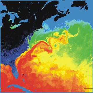
The Gulf Stream, together with its northern extension the North Atlantic Drift, is a warm and swift Atlantic ocean current that originates in the Gulf of Mexico and stretches to the tip of Florida, and follows the eastern coastlines of the United States and Newfoundland before crossing the Atlantic Ocean as the North Atlantic Current. The process of western intensification causes the Gulf Stream to be a northwards accelerating current off the east coast of North America. At about 40°0′N30°0′W, it splits in two, with the northern stream, the North Atlantic Drift, crossing to Northern Europe and the southern stream, the Canary Current, recirculating off West Africa.
Yoldia myalis, or the comb yoldia, is a clam in the family Yoldiidae. It can be found along the Atlantic coast of North America, ranging from Labrador to Massachusetts, as well as along the Alaskan coast.

Yoldia sapotilla, or the short yoldia, is a clam in the family Yoldiidae. It can be found along the Atlantic coast of North America, ranging from Labrador to North Carolina.
Yoldia thraciaeformis, or the broad yoldia, is a clam in the family Yoldiidae. It can be found along the Atlantic coast of North America, from the Arctic Ocean to North Carolina, as well as along the Pacific coast, from the Arctic Ocean to Oregon.
