
Troutdale Airport, also known as Troutdale-Portland Airport, is a corporate, general aviation and flight-training airport serving the city of Troutdale, in Multnomah County, Oregon, United States. It is one of three airports in the Portland metropolitan area owned and operated by the Port of Portland. Troutdale Airport was established in 1920 as a private airfield, then purchased by the Port of Portland in 1942. It serves as a reliever airport for nearby Portland International Airport (PDX).

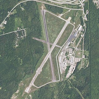
Indiana County–Jimmy Stewart Airport is a county-owned public airport two miles (3 km) east of the borough of Indiana, in Indiana County, Pennsylvania. The airport is about 65 miles (105 km) northeast of Pittsburgh and is in the Pittsburgh Combined Statistical Area. It is classified as a business service airport by the Pennsylvania Bureau of Aviation.

Robert Gray Army Airfield is a military joint-use airport that operates alongside Killeen–Fort Hood Regional Airport. The airport is based inside the south end of the Fort Hood Military Reservation, six nautical miles southwest of the central business district of Killeen, Texas, in unincorporated Bell County.

Winter Haven's Gilbert Airport is a city-owned, public-use airport located three nautical miles (6 km) northwest of the central business district of Winter Haven, a city in Polk County, Florida, United States. It is owned by the City of Winter Haven. It is also known as Winter Haven Regional Airport or Gilbert Field. Jack Browns Seaplane Base is located adjacent to the airport, connected by a taxiway.

Marana Regional Airport, also known as Marana Northwest Regional Airport or Avra Valley Airport, is a non-towered, general aviation airport about 15 miles northwest of Tucson, Arizona in Marana a town in Pima County, Arizona, United States. In 1999, the airport was purchased from Pima County by the town of Marana.

Ryan Airfield, also known as Ryan Field, is a city-owned, public-use airport located 12 miles southwest of the central business district of Tucson, a city in Pima County, Arizona, United States. It is included in the National Plan of Integrated Airport Systems for 2011–2015, which categorized it as a reliever airport. It is mostly used for general aviation but also serves a significant amount of law enforcement and military helicopter activity. Approximately 50% of Ryan's traffic is training-related.

Lake Elmo Airport is a public airport located just outside the city of Lake Elmo in Washington County, Minnesota, United States, about 12 miles east of the central business district of St. Paul. Although most airports in the United States use the same three-letter location identifier for the FAA and International Air Transport Association (IATA), this airport is assigned 21D by the FAA but has no designation from the IATA or ICAO. It is home to the Civil Air Patrol squadron NCR-MN-122.

Riverside Municipal Airport, is four miles (6 km) southwest of downtown Riverside, the county seat of Riverside County, California, United States.

Grayling Army Airfield is a public/military use airport located one nautical mile (1.85 km) northwest of the central business district of Grayling, in Crawford County, Michigan, United States. It is owned by United States Army. The airfield is located 7 miles (11 km) northeast of the main cantonment area of Camp Grayling. It is included in the Federal Aviation Administration (FAA) National Plan of Integrated Airport Systems for 2017–2021, in which it is categorized as a general aviation facility.

Mariposa-Yosemite Airport is a public airport located four miles (6 km) west of the central business district of Mariposa, in Mariposa County, California, United States. It is owned by the County of Mariposa.

Tracy Municipal Airport is three miles (5 km) southwest of Tracy, in San Joaquin County, California. It is owned by the City of Tracy.
Houlton International Airport is a public-use airport located in the town of Houlton in Aroostook County, Maine, United States, near the town border of Hodgdon, Maine, also on the border of New Brunswick, Canada. This general aviation airport is publicly owned by the town of Houlton. It once had scheduled airline service on Northeast Airlines.
Machias Valley Airport is a town owned, public use airport located one nautical mile (2 km) southwest of the central business district of Machias, a town in Washington County, Maine, United States. It is included in the National Plan of Integrated Airport Systems for 2011–2015, which categorized it as a general aviation facility. The airport was once served by commercial airline service on Northeast Airlines.
Cecil Airport is a public airport and commercial spaceport located in Jacksonville, Florida, United States. It is owned by the Jacksonville Aviation Authority and services military aircraft, corporate aircraft, general aviation, and air cargo. The Florida Army National Guard's primary Army Aviation Support Facility and the U.S. Coast Guard's Helicopter Interdiction Tactical Squadron (HITRON) are also located here, the former operating CH-47 Chinook, UH-60 Blackhawk, UH-72 Lakota and C-12 Huron aircraft, and the latter operating the MH-65C Dolphin helicopter.

Perry–Houston County Airport is a public airport located four miles (6 km) northwest of the central business district of Perry, a city in Houston County, Georgia, United States and 10 miles (16 km) south of Warner Robins, Georgia. It is owned by the Perry–Houston County Airport Authority. It is used for general aviation, mainly flight training.

Strother Field is a public airport in Cowley County, Kansas, six miles southwest of Winfield and north of Arkansas City. The airport is jointly owned by the two cities. The National Plan of Integrated Airport Systems for 2011–2015 categorized it as a general aviation facility.

Allen Army Airfield is a public and military use airport serving Fort Greely and located three miles (5 km) south of the central business district of Delta Junction, a city in the Southeast Fairbanks Census Area of the U.S. state of Alaska. It is owned by the United States Army, which has an agreement with the City of Delta Junction for joint use of the airfield by both military and civilian aircraft.

Crystal River Airport – Captain Tom Davis Field is a public airport located three miles (5 km) southeast of the central business district of Crystal River, in Citrus County, Florida, United States. It is owned by Citrus County.
Flagler Executive Airport (ICAO: KFIN, FAA LID: FIN) is a county-owned public-use airport located three miles (5 km) east of the central business district of Bunnell, a city in Flagler County, Florida, United States. The airport's former FAA location identifiers were X47 and XFL. The airfield was originally constructed by the United States Navy during World War II as Naval Outlying Field Bunnell (NOLF Bunnell), an auxiliary airfield for flight training operations originating from nearby Naval Air Station Jacksonville, NAS Daytona Beach and NAS DeLand. Following the end of the war, the airfield was transferred from the Navy to Flagler County for use as a general aviation airport.

Marianna Municipal Airport is an airport in Marianna, Jackson County, Florida, 5 miles (8.0 km) northeast of Downtown Marianna. The Federal Aviation Administration (FAA)'s National Plan of Integrated Airport Systems for 2009–2013 categorized it as a general aviation airport. It was formerly Graham Air Base.


