For the Bhutia community of Sikkim, Yuksom has special religious and cultural significance. It has a number of famous Buddhist monasteries and historical monuments as well as ancient Gurkha villages. Being at the head of the Khangchendzonga National Park and as the base camp for trekking to Mt. Khangchendzonga, it has a large influx of mountaineers from all parts of the world.[5]
Etymology
Yuksom literally means the "meeting place of the three learned monks"[6] as three monks who came from Tibet selected Phuntsog Namgyal as the first King of Sikkim and gave him the title Chogyal. 'Chogyal' means "Religious King" or "the king who rules with righteousness". Yuksom is also one of the sacred landscape "Demazong" (meaning a valley of rice) of four religious sites blessed by Guru Padmasambhava, which are considered to be the four plexuses of the human body, and Yuksom symbolically represents the 'third eye'.[7]
History
Buddhism was introduced to the state from Tibet as early as the 9th century. In Tibet, the struggle for power between the "Yellow hats" and the "Red hats" led to the latter migrating to Sikkim and converting the mild mannered local Lepchas to Buddhism. In the 13th century, relations between Sikkim and Tibet were cemented by a "Brotherhood treaty" signed between the Lepcha chief Thekong Thek and Tibetan prince Khe-Bhumsa at Kavi, in north Sikkim.[8][9][10]
In 1641, Lama Lutsum Chembo ( Lhatsun Chenpo )travelled from Tibet to Drejong (meaning hidden country) now known as Sikkim to propagate the Buddhist religion. He was then joined by two other lamas, Sempa Chembo and Rinzing Chembo. The trinity of Lamas came from the Kham ( Thangut Kingdom) in Tibet. Their primary aim was to perpetuate Tibetan hold on Sikkim and to propagate Buddhism in Sikkim. They assembled from different directions at Norbugang, which later came to be known as Yuksom. The area in the Rathong chu Valley at Narbugong was considered as blessed by the 9th century Guru Padmasambhava (Guru Rinpoche). In 1642 the Lamas went in pursuit of the fourth person, as the current three lamas represented three directions of North, South and West and Padmasambhava's vision had predicted the requirement for a fourth person from the east.
Throne of Norbugang
Near present-day Gangtok, they found a man churning milk. He offered them some refreshments and gave them shelter. So impressed were they by his deeds that they realised that he was a chosen one. They also identified Phunstsog Namgyal's ancestral royal links with Tibet and decided that he was the right person to become the temporal and religious head of the region so brought him to Yuksom. They then crowned him at Norbugang near Yuksom as the temporal and religious king of Sikkim, with the title "Chogyal". The crowning took place at Norbugang on a pedestal set in stones, in a pine-covered hill, and he was anointed by sprinkling water from a sacred urn. At that time he was 38 years of age. He was a fifth generation descendant of Guru Tashi, a 13th-century prince from the Mi-nyak House in Kham in Eastern Tibet.[8][9][10][11][12][13] The stone throne on which the coronation took place still stands and is known as the Throne of Norbugang.[6]
Thereafter, the dynastic rule of Chogyals, propagation of the Buddhist religion and building of monasteries and chortens took firm roots in Sikkim. The Namgyal monarchy of 12 kings lasted from 1642 until 1975 (333 years). Tibetan Mahayana Buddhism known as Vajrayana sect was introduced, which ultimately was recognized as the state religion of Sikkim.[8][9][10][12][13]
Geography and environment
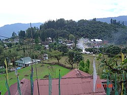
Location map of Yuksom and other religious sites nearby on the Yuksom-Goecha trek routePanoramic view of a village in Yuksom
Yuksom is a large village with a total area of 812.16 hectares (2,006.9 acres) situated at an average altitude of 1,780 metres (5,840ft). It lies in a basin-like valley surrounded by mountain ranges. Located at the head of the Khangchendzonga National Park, it is the gateway to Mt. Kangchenjunga A popular mountaineering trek starts from Yuksom, which is well connected by a road network with Geyzing and Gangtok.[5]
The climate in Yuksom, which is located at a moderate altitude, is pleasant from March to June and September to November, while in the winter season, the coldest months are December and February.[14]
The natural environmental setting of the town, ensconced amidst rich forests is further accentuated by its history, architecture and Buddhist legacy that evolved from the 17th century with Yuksom's establishment as the first capital of Sikkim.[14] Situated at the head of Khangchenjunga National Park, the largest Protected Area in Sikkim, and at starting gate for the trekking trail to Mt. Khangchendzonga, Yuksom and its hills was named in the past as Ney-Pemathang for its beautiful landscape. The forest cover in the hills consist of broad-leaved oak, birch, maple, chestnut, magnolia, rhododendron, silver fir, ash and alder, which complement the epithet of "biodiversity hot-spot" given to Sikkim.[15]
Administration
The main street in Yuksom
The first act that Phuntsog initiated after becoming the King was the conversion of the local Lepcha tribes to Buddhism and set about expanding his kingdom up to the Chumbi Valley in Tibet, parts of modern-day Darjeeling in the south, and parts of eastern Nepal. In this effort the three lamas also lent full support to him.[11]
Phuntsog moved his capital to Yuksom and instituted the first centralised administration. The kingdom was divided into twelve Dzongs or districts under a LepchaDzongpon (governor) who headed a council of twelve ministers. During his reign Buddhism was consolidated as the established religion in Sikkim. He was succeeded by his son, Tensung Namgyal in 1670. However, the importance of Yuksum as capital ended when in 1670, Phuntsok Namgyal's son Tensung Namgyal, shifted the capital to Rabdentse.[11]
At present, Yuksom is a heritage village in the Geyzing subdivision of West District of Sikkim. It is now an important tourist destination. It is also the starting point of the popular trek to Goechala (via Dzongri). It is the base camp of Himalayan Mountaineering Institute for treks to Mt. Khangchendzonga.[13]
Demographics
According to the 2001 census, there are 364 households in the village inhabited by 1,951 persons. However, the visiting population of tourists far exceeds the permanent population as it is on the trekking route and is also as a religious centre for Buddhists. In the village, the Bhutias and the Nepalese constitute major communities, with the Bhutia community being the dominant ethnic group. However, the service and the trading sectors are dominated by people from the plains.[5]
Economy and facilities
Gupta's Restaurant, YuksomHotel Demazong, Yuksom
The village has well established primary and secondary schools. There are three primary schools, one junior school and a senior secondary school. Basic amenities of primary health, potable drinking water, gas and electric supply, post and telegraph office are all well established.[5]
The Yuksom-Dzongri trek is a popular high altitude trek along the Rathong Chu River in West Sikkim. The trek passes through dense forests, alpine lakes and terminates at the Khangchendzonga. An ecotourism impact study of this route has been carried out jointly by the Forest Department, the Mountain Institute and the Khangchendzonga Conservation Committee (KCC), which is based in Yuksom. Considering that this route has recorded large number of visitors (mostly from England, United States, Germany, France, Australia, Netherlands and Switzerland) in the period between 1990 and 2005 (more than doubled in this period of 15 years), two main trekking seasons of March to May and September to November with October being the peak month have been noted. However, the winter months of January and February are the lean months. Based on this study, innovative additional trek routes have been planned to encourage ecotourism all through the year. The additional packages suggested are the "Monsoon Magic" Alpine Treks and Subtropical Winter Treks, which would promote ecotourism economy with due consideration of the carrying capacity of the region.[16][17]
Culture
Biodiversity festival
Dubdi Monastery
As a sequel to the above efforts by the local community, a biodiversity festival was held at Yuksom for one day, the first of its kind to be held in Sikkim, by KCC and the Forest Department of Government of Sikkim. The objective of the festival was to create awareness among the people of the villages to conserve cultural and natural heritage. This festival was attended by 200 villagers and also some foreign tourists. The focus of the festival was on pictorial exhibitions of the natural biodiversity setting and cultural heritage of the Rathong Chuu valley, the steps taken to preserve and conserve the biosphere, interest of ecotourism in the valley along the trek route Yuksom Dzongri through the Khangchendzonga National Park, diverse exhibits relating to medicine, and Khecheopalri Lake pollution and actions for its preservation, effects of deforestation and need to preserve forest wealth.[18]
A Tibetan Buddhist monastery, Dubdi Monastery, is located in the area and with the smaller Mallu Monastery. Established in 1701,the Dubdi Monastery is the oldest monastery in Sikkim and is located at the top of a hill about an hour's walk from Yuksom. It was also known as the Hermit's Cell after its reclusive founder Lhatsun Namkha Jigme.[19]
This page is based on this Wikipedia article Text is available under the CC BY-SA 4.0 license; additional terms may apply. Images, videos and audio are available under their respective licenses.