Zemithang

Last updated
Zemithang
Pangchen
Village
Gorsam Stupa, Zemithang India.jpg
Zemithang.png
Zemithang Circle
India Arunachal Pradesh location map.svg
Red pog.svg
Zemithang
Location in Arunachal Pradesh, India
India location map 3.png
Red pog.svg
Zemithang
Zemithang (India)
Coordinates: 27°42′38″N91°43′48″E / 27.7106891°N 91.7300530°E / 27.7106891; 91.7300530
CountryFlag of India.svg  India
State Arunachal Pradesh
District Tawang
Elevation
2,120 m (6,960 ft)
Population
 (2011)
  Total2,498
Time zone UTC+5:30 (IST)

Zemithang (Tibetan : བྱེ་མ་ཐང།, Wylie : bye ma thang [lower-alpha 1] ) or Pangchen (Tibetan : སྤང་ཆེན, Wylie : spang chen), is a village and the headquarters of an eponymous circle in the Tawang district of Indian state of Arunachal Pradesh. It is on the bank of the Nyamjang Chu river, which originates in Tibet and enters India from the north near the locality called Khinzemane.

Contents

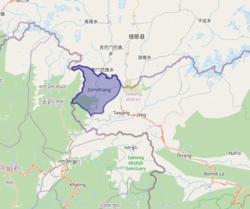
The Zemithang Circle is the last administrative division of India on the border with the Tibet Autonomous Region of China, along the border with Bhutan in the west. [2] [3] [4] It has a population of 2,498 people by the 2011 census, distributed in 18 villages. The Zemithang Circle and the Dudunghar Circle to its south, together make up a community development block. [5] Zemithang's border with Tibet, along the Namka Chu and Sumdorong Chu valleys, is disputed with China. [6]

Zemithang was the first point in India that the 14th Dalai Lama arrived in India as he fled China for India in 1959 following the Chinese occupation of Tibet. [6] He settled at the Tawang Monastery; 70 km southeast, on 30 March before moving on a month later to Uttarakhand to meet then Indian Prime Minister Jawaharlal Nehru. [7] The Dalai Lama has reportedly recalled the area "emotionally" as "a place where I had enjoyed freedom for the first time." [7]

Gorsam Chorten

Gorsam Chorten (Tibetan : གོར་ཟམ་མཆོད་རྟེན།) is a Buddhist stupa (chorten) in Gorsam, 3 km southwest of the Zemithang village. The history of the stupa remained unknown as the only written records of it were either lost or destroyed. [8] Legend has it that it was built sometime between 12-14th century by a local Buddhist monk named Lama Sangye Pradhar to ward off evil spirits in the village. [8] As he travelled to Bhutan and subsequently Kathmandu, Nepal to raise funds for the stupa, he was fascinated by the Boudhanath Stupa [9] (some sources [8] cited the Swayambhunath Stupa) and carved a miniature of it out of a radish. He brought the radish sculpture back to Zemithang, where Gorsam Chorten was built as a replica stupa based on it. It was said that the Zemithang stupa is different from the Kathmandu original owing to the radish miniature that had shrivelled. [8] The stupa is roughly 28 m high and is the site of annual Gorsam Kora festival where reportedly thousands of Buddhists attend. [9]

Notes

  1. also Zimithang or Jemeithang; [1] , also Tibetan: བྱེ་མའི་ཐང།, Wylie: bye ma'i thang

Related Research Articles

<span class="mw-page-title-main">Arunachal Pradesh</span> State in northeast India

Arunachal Pradesh is a state in northeast India. It was formed from the North-East Frontier Agency (NEFA) region, and India declared it as a state on 20 February 1987. Itanagar is its capital and largest town. It borders the Indian states of Assam and Nagaland to the south. It shares international borders with Bhutan in the west, Myanmar in the east, and a disputed 1,129 km border with China's Tibet Autonomous Region in the north at the McMahon Line.

<span class="mw-page-title-main">Monpa people</span> Major tribe of Arunachal Pradesh, India

The Monpa is a major tribe of Arunachal Pradesh in northeastern India. The Tawang Monpas have a migration history from Changrelung. The Monpa are believed to be the only nomadic tribe in Northeast India – they are totally dependent on animals like sheep, cow, yak, goats and horses. The Monpa have a very close affinity with the Sharchops of Bhutan.

<span class="mw-page-title-main">Tawang district</span> District of Arunachal Pradesh in India

Tawang district is the smallest of the 26 administrative districts of Arunachal Pradesh state in northeastern India. With a population of 49,977, it is the eighth least populous district in the country.

<span class="mw-page-title-main">6th Dalai Lama</span> Spiritual leader of Tibet from 1697 to 1706

Tsangyang Gyatso was the 6th Dalai Lama. He was an unconventional Dalai Lama that preferred a libertine lifestyle to that of an ordained monk. His regent was killed before he was kidnapped by Lha-bzang Khan of the Khoshut Khanate and disappeared.

<span class="mw-page-title-main">Tawang</span> Town in Arunachal Pradesh, India

Tawang is a town and administrative headquarter of Tawang district in the Indian state of Arunachal Pradesh. It lies on NH-13 section of Trans-Arunachal Highway. The town was once the capital of the Tawang Tract, which is now divided into the Tawang district and the West Kameng district. Tawang continues as the headquarters of the former. Tawang is the number one tourist destination of Arunachal Pradesh.

<span class="mw-page-title-main">Buddhist pilgrimage sites in India</span>

In religion and spirituality, a pilgrimage is a long journey or search of great moral significance. Sometimes, it is a journey to a sacred place or to a shrine of importance to a person's beliefs and faith. Members of every major religion participate in pilgrimages. A person who makes such a journey is called a pilgrim.

This is a list of topics related to Tibet.

<span class="mw-page-title-main">Tsona</span> County-level city in Tibet, China

Tsona City, formerly Tsona County, is a county-level city in Shannan Prefecture in southern part of the Tibet region of China. Tsona means "The face of the [Nara Yumco] lake" in Tibetan. It lies immediately to the north of the McMahon Line agreed as the mutual border between British India and Tibet in 1914. China has not accepted the 1914 border delineation, but treats it as the Line of Actual Control (LAC). Tsona also borders Bhutan on its southwest.

<span class="mw-page-title-main">Lhatse (town)</span> Place in Tibet, Peoples Republic of China

The new town of Lhatse or Lhatse Xian, also known as Quxar (Tibetan: ཆུ་ཤར་, Quxia, or Chusar, is a small town of a few thousand people in the Tibet Autonomous Region in the valley of the Yarlung Tsangpo River in Lhatse County, 151 kilometres southwest of Shigatse and just west of the mountain pass leading to it. Lhatse is 4,050 metres above sea-level.

<span class="mw-page-title-main">Gaocheng, Sichuan</span> Town in Sichuan, China

Gaocheng Town, also known as Litang, is the administrative centre of Litang County in the southwest of the Garzê Tibetan Autonomous Prefecture in Sichuan Province of China.

Trashi Yangtse is one of the district located in the eastern part of Bhutan and has eight gewogs. It houses the Bumdeling Wildlife Sanctuary on the eastern tri-junction of Bhutan-India-China and to the east lies Tawang in India. The nearest airport is Yongphulla Airport 130 km away.

<span class="mw-page-title-main">Tawang Monastery</span> Tibetan Buddhist monastery in Tawang, Arunachal Pradesh, India

Tawang Monastery, located in Tawang city of Tawang district in the Indian state of Arunachal Pradesh, is the largest monastery in India. It is situated in the valley of the Tawang Chu, near the small town of the same name in the northwestern part of Arunachal Pradesh, in close proximity to the Chinese and Bhutanese border.

<span class="mw-page-title-main">Buddhism in Himachal Pradesh</span>

Buddhism in the Himachal Pradesh state of India of has been a long-recorded practice. The spread of Buddhism in the region has occurred intermediately throughout its history. Starting in the 3rd century BCE, Buddhism was propagated by the Maurya Empire under the reign of Ashoka. The region would remain an important center for Buddhism under the Kushan Empire and its vassals. Over the centuries the following of Buddhism has greatly fluctuated. Yet by experiencing revivals and migrations, Buddhism continued to be rooted in the region, particularly in the Lahaul, Spiti and Kinnaur valleys.

<span class="mw-page-title-main">Yarlung Valley</span> Human settlement in China

The Yarlung Valley is formed by Yarlung Chu, a tributary of the Tsangpo River in the Shannan Prefecture in the Tibet region of China. It refers especially to the district where Yarlung Chu joins with the Chongye River, and broadens out into a large plain about 2 km wide, before it flows into the Tsangpo River. It is situated in Nedong District of the Shannan Prefecture and includes the capital of the prefecture, Tsetang, one of Tibet's largest cities, 183 km southeast of Lhasa.

<span class="mw-page-title-main">Tibetan dual system of government</span> Dual system of a government in Tibet

The Dual System of Government is the traditional diarchal political system of Tibetan peoples whereby the Desi coexists with the spiritual authority of the realm, usually unified under a third single ruler. The actual distribution of power between institutions varied over time and location. The Tibetan term Cho-sid-nyi literally means "both Dharma and temporal," but may also be translated as "dual system of religion and politics."

<span class="mw-page-title-main">Takpa language</span> Bodish language spoken in Tibet and Bhutan

The Takpa or Dakpa language, Dakpakha, known in India as Tawang Monpa, also known as Brami in Bhutan, is an East Bodish language spoken in the Tawang district of Arunachal Pradesh, and in northern Trashigang District in eastern Bhutan, mainly in Kyaleng, Phongmed Gewog, Dangpholeng and Lengkhar near Radi Gewog. Van Driem (2001) describes Takpa as the most divergent of Bhutan's East Bodish languages, though it shares many similarities with Bumthang. SIL reports that Takpa may be a dialect of the Brokpa language and that it been influenced by the Dzala language whereas Brokpa has not.

<span class="mw-page-title-main">India–Tibet relations</span> Relations between Tibet and India

Tibet–India relations are said to have begun during the spread of Buddhism to Tibet from India during the 6th century AD. In 1959, the Dalai Lama fled to India after the failed 1959 Tibetan uprising. Since then, Tibetans-in-exile have been given asylum in India, with the Indian government accommodating them into 45 residential settlements across 10 states in the country. From around 150,000 Tibetan refugees in 2011, the number fell to 85,000 in 2018, according to government data. Many Tibetans are now leaving India to go back to Tibet and other countries such as United States or Germany. The Government of India, soon after India's independence in 1947, treated Tibet as a de facto independent country. However, more recently India's policy on Tibet has been mindful of Chinese sensibilities, and has recognized Tibet as a part of China.

Nyamjang Chu, or Nyashang Chu (Tibetan: ཉ་བཤང་ཆུ, Wylie: nya bshang chu, THL: nya shang chu) is a cross-border perennial river that originates in the Shannan Prefecture of Tibet and flows into the Arunachal Pradesh state of India, joining the Tawang Chu river just before it enters Bhutan. The Nyamjang Chu valley has provided the traditional communication route between Tawang and Tibet. The valley near town of Zemithang in the Tawang district, called the Pangchen Valley, is known for its serene beauty and forms one of the wintering locations for the black-necked crane.

Chumi Gyatse Falls, called Domtsang and Dongzhang waterfalls in Tibetan and Chinese languages respectively, are a collection of waterfalls in the Tawang district in Arunachal Pradesh, India, close to the border with the Tibet region of China. According to the local Buddhist tradition, the 108 holly water falls which originate from in-between the mountains symbolise the blessings of Guru Padmasambhava. The Chumi Gyatse Falls are close to the Line of Actual Control, the de facto border between China and India, just 250 metres away according to one account.

References

  1. Kalita, Kangkan (2023-03-21). "Tree planted by 14th Dalai Lama near LAC in Arunachal a big hit". The Times of India . Retrieved 2023-06-02.
  2. Sang Khandu (APCS, Circle Officer, Bomdila). "Leaves of Pangchen" (PDF). Retrieved 12 July 2021.{{cite web}}: CS1 maint: uses authors parameter (link)
  3. Chowdhary, Charu (2019-07-23). "Zemithang: An Oasis of Calm And Tranquility in Arunachal Pradesh". India.com. Retrieved 2021-07-12.
  4. "Community from Zemithang Valley bags award for forest conservation". www.wwfindia.org. WWF-India. 10 December 2015. Retrieved 2021-07-12.
  5. Tawang District Census Handbook, Part A (PDF), Directorate of Census Operations, Arunachal Pradesh, 2011, pp. 28, 77
  6. 1 2 "Taking the high road: India infrastructure drive counters China". RFI . 2023-05-04. Retrieved 2023-07-07.
  7. 1 2 "How the Dalai Lama escaped to Arunachal Pradesh 58 years back". Indian Express . 2020-07-06. Retrieved 2023-07-07.
  8. 1 2 3 4 S. Banerjee, Partha (2003-03-16). "The solitary splendour of a stupa in the wilderness". The Tribune - Sunday. Retrieved 2023-07-07.
  9. 1 2 "Gorsam Chorten Zemithang, Tawang". Government of Arunachal Pradesh . 2023-06-28. Retrieved 2023-07-07.