
Shravanabelagola is a town located near Channarayapatna of Hassan district in the Indian state of Karnataka and is 144 km (89 mi) from Bengaluru. The Gommateshwara Bahubali statue at Shravanabelagola is one of the most important tirthas in Jainism, one that reached a peak in architectural and sculptural activity under the patronage of Western Ganga dynasty of Talakad. Chandragupta Maurya is said to have died on the hill of Chandragiri, which is located in Shravanabelagola, in 298 BCE after he became a Jain monk and assumed an ascetic life style.

Sanchi is a Buddhist complex, famous for its Great Stupa, on a hilltop at Sanchi Town in Raisen District of the State of Madhya Pradesh, India. It is located, about 23 kilometers from Raisen town, district headquarter and 46 kilometres (29 mi) north-east of Bhopal, capital of Madhya Pradesh.

A milestone is a numbered marker placed on a route such as a road, railway line, canal or boundary. They can indicate the distance to towns, cities, and other places or landmarks like mileage signs; or they can give their position on the route relative to some datum location. On roads they are typically located at the side or in a median or central reservation. They are alternatively known as mile markers, mileposts or mile posts. A "kilometric point" is a term used in metricated areas, where distances are commonly measured in kilometres instead of miles. "Distance marker" is a generic unit-agnostic term.

Ellora Caves are a multi-religious rock-cut cave complex with inscriptions dating from the period 6th century CE onwards, located in the Aurangabad District of Maharashtra, India. They are also called verul caves.

Nagpur is the third-largest city of the Indian state of Maharashtra after Mumbai and Pune. Known as the "Orange City", Nagpur is the 13th largest city in India by population and according to an Oxford's Economics report, Nagpur is projected to be the fifth fastest growing city in the world from 2019 to 2035 with an average growth of 8.41%. It has been proposed as one of the Smart Cities in Maharashtra and is one of the top ten cities in India in Smart City Project execution.

The Archaeological Survey of India (ASI) is an Indian government agency that is responsible for archaeological research and the conservation and preservation of cultural historical monuments in the country. It was founded in 1861 by Alexander Cunningham who also became its first Director-General.

Aihole (ಐಹೊಳೆ), also referred to as Aivalli, Ahivolal or Aryapura, is a historic site of ancient and medieval era Buddhist, Hindu and Jain monuments in Karnataka, India that dates from the sixth century through the twelfth century CE. Most of the surviving monuments at the site date from the 7th to 10th centuries. Located around an eponymous small village surrounded by farmlands and sandstone hills, Aihole is a major archaeological site featuring over one hundred and twenty stone and cave temples spread along the Malaprabha river valley, in Bagalakote district.

Bharhut is a village located in the Satna district of Madhya Pradesh, central India. It is known for its famous relics from a Buddhist stupa. What makes Bharhut panels unique is that each panel is explicitly labelled in Brahmi characters mentioning what the panel depicts. The major donor for the Bharhut stupa was King Dhanabhuti.

Deekshabhoomi is a sacred monument of Navayana Buddhism located in Nagpur city in the state of Maharashtra in India; where B. R. Ambedkar with approximately 400,000 of his followers– mainly Dalits, several thousand of whom had been converted to Christianity– embraced Buddhism on Ashoka Vijaya Dashami on 14 October 1956. Ambedkar played a significant role in the revival of Buddhism in India, and inspired many such mass conversions to Buddhism.

In many countries, kilometre zero or similar terms in other languages denote a particular location from which distances are traditionally measured and some use this as their official country location or coordinates for faster search at space satellites, this is also used for measuring distances between different countries around the world. Historically, they were markers where drivers could set their odometers to follow the directions in early roaming guide books.
Pauni is a town and a Municipal Council in Bhandara district in the Indian state of Maharashtra. Now it has National Highway NH-247. Pauni is also known as Kashi of Vidarbha due to its wide swath of temples.

Hajo is a historic town set in the hills northwest of Guwahati, Assam, India. It is a meeting point of Buddhists, Hindus and Muslims due to the various pilgrimage sites on the different hills of Hajo. To the Hindus, the Manikut Parbat of Hajo is the site of the 10th-century temple ruins and the 11th- to 16th-century temples complex for Vaishnavism as well as shrines of Shaivism and Shaktism. To the Buddhists, particularly from Bhutan and Tibet, Assam is where the Buddha died and the Hayagriva temple in Hajo is a part of the sacred geography of the Buddha. To the regional Muslims, the Mughal era Poa-Mecca shrine on another hill of Hajo has the tomb of Giyasuddin Aulia built in the 17th-century.

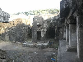
Bhaja Caves are a group of 22 rock-cut caves dating back to the 2nd century BC located off the Mumbai - Pune expressway near the city of Pune, India. The caves are 400 feet above the village of Bhaja, on an important ancient trade route running from the Arabian Sea eastward into the Deccan Plateau. The inscriptions and the cave temple are protected as a Monument of National Importance, by the Archaeological Survey of India per Notification No. 2407-A. It belongs to the Early Buddhist schools in Maharashtra. The caves have a number of stupas, one of their significant features. The most prominent excavation is its chaitya, a good example of the early development of this form from wooden architecture, with a vaulted horseshoe ceiling. Its vihara has a pillared verandah in front and is adorned with unique reliefs. These caves are notable for their indications of the awareness of wooden architecture. The carvings prove that tabla – a percussion instrument – was used in India for at least 2300 years, disproving the centuries-held belief that the tabla was introduced to India by outsiders or from Turko-Arab. The carving shows a woman playing tabla and another woman, performing dance.

The economy of the state of Maharashtra is the largest in India. Mumbai, the capital of Maharashtra is considered the financial capital of India with the headquarters of almost all major banks, financial institutions, insurance companies and mutual funds being based in the city. India's largest stock exchange Bombay Stock Exchange, the oldest in Asia, is also located in the city. More than 41% of the S&P CNX 500 conglomerates have corporate offices in Maharashtra.
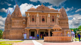
Bhadresar or Bhadreshwar is a village in Mundra Taluka, Kutch district of Gujarat, India. It is about 27 km from Taluka headquarters Mundra and barely a kilometer away from the seashore.

Nagpur Metro is a rapid transit system for the city of Nagpur, Maharashtra, India. Phase I of the metro project cost was estimated to cost ₹8,650 crore but the final project cost incurred was ₹9,279 crore (US$1.2 billion). In February 2014, the Government of Maharashtra gave approval for the Metro project, while the Government of India's Ministry of Urban Development had given "In Principle" approval for the project. On 20 August 2014, Union Cabinet gave approval for the development of the project, and the Prime Minister laid the foundation stone on 21 August. Construction began on 31 May 2015, with trial run beginning on 30 September 2017.

Bhima Ratha is a monument in the Pancha Rathas complex at Mahabalipuram, on the Coromandel Coast of the Bay of Bengal, in the Kancheepuram district of the state of Tamil Nadu, India. It is an example of monolith Indian rock-cut architecture. Dating from the late 7th century, it is attributed to the reign of King Mahendravarman I and his son Narasimhavarman I of the Pallava Kingdom. The entire complex is under the auspices of the Archaeological Survey of India (ASI), and is one of the Group of Monuments at Mahabalipuram designated as a UNESCO World Heritage Site since 1984.
The Shivleni Caves in Ambajogai, Maharashtra, India are rock-cut cave monuments which date in King Udayaditya from Paramara dynasty of Malwa. Total excavations were hewn out of rock cut and carved deep inside the hill. The caves include sculptures of Hindu deities like Shiva, Saptamatrukas and Ganesha.
Zero Mile or variation, may refer to:

Zero Mile Freedom Park is an elevated metro station on the North-South corridor of the Orange Line of Nagpur Metro in the city of Nagpur, Maharashtra. It is named after the nearby Zero Mile Stone which was built in 1907 to mark the Great Trigonometrical Survey of India. The station was opened on 21 August 2021.

