Zielonki | |
|---|---|
Village | |
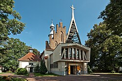 Church of the Nativity of the Virgin Mary | |
 Zielonki | |
| Coordinates: 50°07′N19°55′E / 50.117°N 19.917°E | |
| Country | |
| Voivodeship | Lesser Poland |
| Powiat | Kraków |
| Gmina | Zielonki |
| Government | |
| Area | |
• Total | 6.14 km2 (2.37 sq mi) |
| Time zone | UTC+1 (CET) |
| • Summer (DST) | UTC+2 (CEST) |
| Postal code | 32-087 |
| Car Plates | KRA |
Zielonki [ʑɛˈlɔnki] is a village in southern Poland. It is located in the Lesser Poland Voivodeship and it is also the administrative center of the Gmina Zielonki. [1] It lies approximately 7 kilometres (4 mi) north of the regional capital Kraków.
