
Tybouts Corner is an unincorporated populated place in New Castle County, Delaware, United States. It is located at the intersection of U.S. Route 13 and Hamburg Road/Bear Tybouts Road just north of an interchange with Delaware Route 1 and an intersection with the northern terminus of Delaware Route 71. Tybouts Corner is located at 39°37′12″N75°38′32″W and has an elevation of 52 feet (16 m).

Çifteler is a town and district of Eskişehir Province in the Central Anatolia region of Turkey. According to 2000 census, population of the district is 16,716 of which 11,872 live in the town of Çifteler. The district covers an area of 820 km2 (317 sq mi), and the average elevation is 875 m (2,871 ft).

The Pontchartrain Center is a 4,600-seat multi-purpose arena in Kenner, Louisiana, USA. The facility opened in 1991. It hosts concerts and local sporting events.

Marratxí is a municipality in the Raiguer region of Majorca, one of the Balearic Islands of Spain. As of 2005, it has a population of 28,237 and an area of 54 km². It is also a station on the Majorca rail network. It became a municipality on 9 November 1932.

Bliż is a village in the administrative district of Gmina Kąty Wrocławskie, within Wrocław County, Lower Silesian Voivodeship, in south-western Poland. Prior to 1945 it was in Germany.
Cù Lao Dung is a rural district (huyện) of Sóc Trăng Province in the Mekong River Delta region of Vietnam. As of 2003 the district had a population of 62,025. The district covers an area of 235 km². The district capital lies at Cù Lao Dung.
Mỹ Tú is a rural district (huyện) of Sóc Trăng Province in the Mekong River Delta region of Vietnam. As of 2003 the district had a population of 207,634. The district covers an area of 588 km². The district capital lies at Huỳnh Hữu Nghĩa.
Thạnh Trị is a district (huyện) of Sóc Trăng Province in the Mekong River Delta region of Vietnam. As of 2003 the district had a population of 86,262. The district covers an area of 281 km². The district capital lies at Phú Lộc.
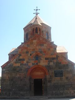
Arevshat is a village in the Ararat province of Armenia.

The Trnovo District, or simply Trnovo, is a district of the City Municipality of Ljubljana, the capital of Slovenia.
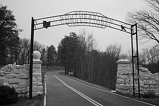
Southeastern Correctional Institution is an Ohio prison located at 5900 Boys Industrial School Road in Hocking Township, Fairfield County, six miles south of Lancaster, Ohio. The facility originally opened as a reform school for male juvenile offenders. It currently houses 2,034 inmates with either minimum or medium security levels.
Bazar Ahmed Khan is a town and union council of Bannu District in Khyber Pakhtunkhwa province of Pakistan. It is located at 32°59'6N 70°38'32E and has an altitude of 344 metres.
Sroków is a village in the administrative district of Gmina Wielgomłyny, within Radomsko County, Łódź Voivodeship, in central Poland. It lies approximately 3 kilometres (2 mi) north of Wielgomłyny, 23 km (14 mi) east of Radomsko, and 86 km (53 mi) south of the regional capital Łódź.
Stróża is a village in the administrative district of Gmina Ożarów, within Opatów County, Świętokrzyskie Voivodeship, in south-central Poland. It lies approximately 2 kilometres (1 mi) west of Ożarów, 19 km (12 mi) north-east of Opatów, and 73 km (45 mi) east of the regional capital Kielce.
Józefosław is a village in the administrative district of Gmina Piaseczno, within Piaseczno County, Masovian Voivodeship, in east-central Poland. It lies approximately 5 kilometres (3 mi) north of Piaseczno and 13 km (8 mi) south of Warsaw.
Racław is a settlement in the administrative district of Gmina Polanów, within Koszalin County, West Pomeranian Voivodeship, in northwestern Poland.

Bare is a village in Požarevac, Serbia.

Trbuk is a village in the municipality of Maglaj, Bosnia and Herzegovina.

State Correctional Institution – Somerset is a Medium-Security, all male correctional facility located outside Somerset, Pennsylvania, about 70 miles southeast of Pittsburgh, and about five miles off the Somerset Interchange of the Pennsylvania Turnpike.
Arfanabad is a village in Katul Rural District, in the Central District of Aliabad County, Golestan Province, Iran. At the 2006 census, its population was 904, in 185 families.


