
Azerbaijan, officially the Republic of Azerbaijan, is a country in the South Caucasus region of Eurasia at the crossroads of Eastern Europe and Western Asia. It is bounded by the Caspian Sea to the east, Russia to the north, Georgia to the northwest, Armenia to the west and Iran to the south. The exclave of Nakhchivan is bounded by Armenia to the north and east, Iran to the south and west, and has an 11 km (6.8 mi) long border with Turkey in the northwest.

Lezgins are a Northeast Caucasian ethnic group native predominantly to southern Dagestan, Russia and northeastern Azerbaijan and who speak the Lezgian language.

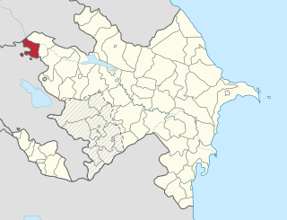
Quba is a rayon in northeastern Azerbaijan. The capital, Quba, is located on the Qudyal River at 41.37°N, 48.50°E.

Lerik Rayon is a rayon located near the Iranian border in southern Azerbaijan, between the tall mountains of the Talysh Mountains and the agricultural plain of the Lankaran Lowland.

Aghstafa is a rayon in the northwestern Azerbaijan.It has two farmland exclaves inside Armenia, Jaradollo both of which came under Armenian control during the Nagorno-Karabakh War.

Astara is the southernmost rayon in southeastern Azerbaijan.
Gazakh is a rayon of Azerbaijan. It has two exclaves inside Armenia, Yukhari Askipara and Barkhudarli, Sofulu both of which came under Armenian control during the Nagorno-Karabakh War.

The District of Qusar is an administrative unit in the northern part of Azerbaijan. Its administrative center is Qusar city.

Shamkir is a region in Azerbaijan. It is located in the northwestern part of the Azerbaijan Republic. The rayon was previously called "Shamkhor" during the Soviet rule and was renamed to Shamkir only in 1991 after restoration of independence of Azerbaijan. The district was established in 1930. The capital of Shamkir Rayon is Shamkir city.

Zaqatala is a rayon of Azerbaijan. The capital and principal town is Zaqatala. The rayon is an appendix of Azerbaijan territory wedged between Kakheti (Georgia) and Dagestan. It is served by the A315 road coming from Mingachevir and leading to the Georgian border at Lagodekhi as well as by a small airfield.

Karki or Tigranashen is a village that is de jure an exclave of the Nakhchivan Autonomous Republic of Azerbaijan. The village is near the border with Armenia, located on the bank of the Arpachay River near the Yerevan-Jermuk highway, which is 15 kilometres (9.3 mi) away from the district center. The area of the village itself is 950 hectares. Karki is de jure within the administrative territory of the Sadarak Rayon of Nakhchivan. It was occupied on January 19, 1990, by Armenian forces.

The Nagorno-Karabakh War was an ethnic and territorial conflict that took place in the late 1980s to May 1994, in the enclave of Nagorno-Karabakh in southwestern Azerbaijan, between the majority ethnic Armenians of Nagorno-Karabakh backed by Armenia, and the Republic of Azerbaijan. As the war progressed, Armenia and Azerbaijan, both former Soviet Republics, entangled themselves in protracted, undeclared mountain warfare in the mountainous heights of Karabakh as Azerbaijan attempted to curb the secessionist movement in Nagorno-Karabakh. The enclave's parliament had voted in favor of uniting itself with Armenia and a referendum, boycotted by the Azerbaijani population of Nagorno-Karabakh, was held, whereby most of the voters voted in favor of independence. The demand to unify with Armenia began in a relatively peaceful manner in 1988; in the following months, as the Soviet Union disintegrated, it gradually grew into an increasingly violent conflict between Armenians and Azerbaijanis, resulting in ethnic cleansing, with Sumgait pogrom (1988), Baku pogrom (1990) and Khojaly Massacre (1992) being notable examples.
Artsakh is located in the southern part of the Lesser Caucasus range, at the eastern edge of the Armenian Highlands, encompassing the highland part of the wider geographical region known as Karabakh. Under Russian and Soviet rule, the region came to be known as Nagorno-Karabakh, meaning "Mountainous Karabakh" in Russian. The name Karabakh itself was first employed in Georgian and Persian sources from the 13th and 14th centuries to refer to an Armenian principality known by modern historians as the Kingdom of Artsakh or Khachen.

Artsvashen, also Romanized as Artzvashen, is an enclave of Armenia's Gegharkunik province which has been occupied by the Azerbaijani army since 1992. The official Azerbaijani name for the village is Başkənd. Its size is about 40 square kilometres, and it is completely surrounded by the territory of Azerbaijan and has been controlled by it since the Nagorno-Karabakh War. Today, the village is mostly inhabited by Azeris as the Azerbaijani army expelled its Armenian population after it seized the territory and is now administered by Azerbaijan as part of Gadabay Rayon.

Motolayataq is a village and municipality in the Astara Rayon of Azerbaijan. It has a population of 1,108. The municipality consists of the villages of Motalayataq, Anbabu, Vələparqo, Əkbərməhlə, and Şıxımpeştə.
Günəşli is a village and municipality in the Lerik Rayon of Azerbaijan. It has a population of 1,022. The municipality consists of the villages of Günəşli and Babagil.
Budenovka is a village in the Saatly Rayon of Azerbaijan.

Zandabad is a village in Owch Hacha Rural District, in the Central District of Ahar County, East Azerbaijan Province, Iran. At the 2006 census, its population was 1,104, in 224 families.
Nakhchivan or Nakhichevan may refer to:

