Related Research Articles
Laich-kwil-tach, is the Anglicization of the Kwak'wala autonomy by the "Southern Kwakiutl" people of Quadra Island and Campbell River in British Columbia, Canada. There are today two main groups : the Wei Wai Kai and Wei Wai Kum just across on the Vancouver Island "mainland" in the town of Campbell River. In addition to these two main groups there are the Kwiakah originally from Phillips Arm and Frederick Arm and the Discovery Islands, the Tlaaluis (Laa'luls) between Bute and Loughborough Inlets—after a great war between the Kwakiutl and the Salish peoples they were so reduced in numbers that they joined the Kwiakah—and the Walitsima / Walitsum Band of Salmon River.

The Gwa'Sala-Nakwaxda'xw Nations are a union of two Kwakwaka'wakw peoples in a band government based on northern Vancouver Island in British Columbia, Canada, whose main reserve community is near the town of Port Hardy in the Queen Charlotte Strait region of the Central Coast region of British Columbia, Canada. The band government is a member of the Kwakiutl District Council and, for treaty negotiation purposes, the Winalagalis Treaty Group which includes three other members of the Kwakiutl District Council.
Ḵwiḵwa̱sut'inux̱w Ha̱xwa'mis, formerly the Kwicksutaineuk-ah-kwa-mish First Nation is a First Nations band government based on northern Vancouver Island in British Columbia, Canada, in the Queen Charlotte Strait region. It is a member of the Musgamagw Tsawataineuk Tribal Council, along with the ‘Namgis First Nation and the Tsawataineuk First Nation. The Kwikwasut'inuxw and Haxwa'mis are two of the many subgroups of the peoples known as Kwakwaka'wakw, which has two meanings: "smoke of the world" or "beach at the north side of the river."
The Tsawataineuk First Nation is a First Nations band government in the Queen Charlotte Strait region north of northern Vancouver Island in the Canadian province of British Columbia. It is a member of the Musgamagw Tsawataineuk Tribal Council, along with the Gwawaenuk and the Kwicksutaineuk-ah-kwa-mish First Nation.
The Wuikinuxv Nation, also known as the Oweekeno Nation, is a First Nations band government whose traditional territory is the shores of Rivers Inlet and Owikeno Lake in the Central Coast region of the Canadian province of British Columbia, in the area south of Bella Bella and north of Queen Charlotte Strait. The Wuikinuxv people a.k.a. the Oweekeno people reside in the area of Rivers Inlet and Owikeno Lake, primarily at a village on the Wannock River. Substantial numbers of Wuikinuxv also reside away from the traditional territory in Port Hardy on Vancouver Island and in larger BC communities such as Campbell River, Vancouver and Victoria. Approximately 80 people reside at the village while overall membership was 283 in 2006, 194 of whom lived off-reserve.

The 'Namgis are an Indigenous nation, a part of the Kwakwaka'wakw, in central British Columbia, on northern Vancouver Island. Their main village is now Yalis, on Cormorant Island adjacent to Alert Bay. The Indian Act First Nations government of this nation is the Namgis First Nation. They were formerly known as the Nimpkish.
The Mamalilikulla Band is a First Nations band government based on northern Vancouver Island in British Columbia, Canada. The home territory of the Mamalilikulla and Qwe-Qwa'Sot'Em groups of Kwakwaka'wakw was in the maze of islands and inlets of the eastern Queen Charlotte Strait region around the opening of Knight Inlet, mainly on Village Island, where their principal village Memkumlis is.

The ƛoʔos Klahoose are one of the three groups comprising the ʔayʔaǰuθəm Tla'Amin or Mainland Comox. The other two divisions of this once-populous group are the χʷɛmaɬku Homalco and Sliammon. The Klahoose, Homalco and Sliammon are, according to oral tradition, the descendants of the survivors of the Great Flood. The three groups were split by colonialism into different band councils but united historically as the Tla A'min, known as the Mainland Comox, and K’ómoks, the larger grouping of the Comox people, also known as the Island Comox and before the merger with the Laich-kwil-tach culture. Historically both groups are a subgroup of the Coast Salish though the K’ómoks name is from, and their language today, is the Lik'wala dialect of Kwak'wala. The ancestral tongue is the Comox language, though the Sahtloot/Island dialect is extinct.
New Vancouver, also known as Tzatsisnukomi, T˜sadzis' nukwame' or t̕sa̱dzis'nukwa̱me'' in the Kwak'wala language, is a Kwakwaka'wakw community on Harbledown Island in the Queen Charlotte Strait region of the Central Coast of British Columbia, near the community of Alert Bay. New Vancouver is the main village of the Da'naxda'xw subgroup of the Kwakwaka'wakw peoples. New Vancouver is at Dead Point on the north end of Harbeldown Island, at the west end of Beware Passage.
Smith Sound is a sound on the Central Coast of British Columbia, Canada, located to the south of Rivers Inlet and between the Queen Charlotte Strait region (S) and Fitz Hugh Sound (N).
The Tlowitsis Nation, formerly the Klowitsis Tribe, the Turnour Island Band and the Tlowitsis-Mumtagila First Nation, is the Indian Act band government of the Ławit'sis (Tlowitsis) tribe of the Kwakwaka'wakw peoples, located in the Queen Charlotte Strait-Johnstone Strait area in the Discovery Islands between Vancouver Island and the British Columbia mainland in Canada. Ławit'sis territory covers parts of northern Vancouver Island, Johnstone Strait, and adjoining inlets of the mainland. Kalugwis, on Turnour Island, was their principal community in times past, but the band's offices are in the city of Campbell River to the southeast. Hanatsa IR No. 6 on Port Neville is the most populated of the band's Indian reserves.
The Gwawaenuk Tribe, or Gwawaʼenux̱w is a First Nations band government of the Kwakwaka'wakw people located in the Queen Charlotte Strait region of the Central Coast region of British Columbia, Canada. The Gwawaenuk Tribe has no year-round road access to a service centre and being about 160 km to 240 km from the nearest service centre.
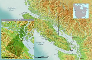
The We Wai Kai Nation, also known as the Wewaikai First Nation, the Cape Mudge First Nation and the Cape Mudge Indian Band, is the band government of the We Wai Kai subgroup of the Laich-kwil-tach group of the Kwakwaka'wakw peoples, based on Quadra Island offshore from Campbell River, British Columbia, Canada, which is on the east coast of Vancouver Island at the northern end of the Strait of Georgia. The Laich-kwil-tach include the Wei Wai Kum, who are organized as the Campbell River First Nation, and the Kwiakah Nation, whose traditional territory is in the Discovery Islands to the northeast of that city and on the adjoining mainland coast. All three are part of the Kwakiutl District Council, a tribal council which includes other Kwakwaka'wakw bands farther northwest in the Queen Charlotte Strait region and on northern Vancouver Island.
Cormorant Island is an island in Queen Charlotte Strait on the Central Coast of British Columbia, Canada. It has a total land area of about 4 square km and is located south of Malcolm Island and east of Port McNeill.

The Nimpkish River is a river in northern Vancouver Island in British Columbia, Canada. It is the longest river on the Island, rising on the west slope of Mount Alston, flowing northwest into Nimpkish Lake and then north into the Broughton Strait at a point 8 km east of Port McNeill, just southwest of the town of Alert Bay on Cormorant Island.
The Pearse Islands are a small group of islands in the Queen Charlotte Strait region of the Central Coast of British Columbia, Canada. They are just east of Cormorant Island, which is the location of the Village of Alert Bay. Cormorant Channel Marine Provincial Park is located in this group of islands.
The Adam River is a river on northern Vancouver Island, British Columbia, Canada, flowing north into the Johnstone Strait northwest of the community of Sayward. The Adam's main tributary is the Eve River. The Kwak'wala name for the river is He-la-de, meaning "land of plenty", a reference to abundant berries, birds, game and salmon. That name is reflected in that of Haylahte Indian Reserve No. 3, which is on the east bank of the Adam's mouth. The former Matilpi village of Klaywatse was located on an island in the river's estuary.
Apsigiyu or Apsigayu or Apsagayu is a village site of the Kwikwasut'inuxw and Mamalilikulla groups of the Kwakwaka'wakw peoples, located at the head of Shoal Harbour on the northwest side of Gilford Island, in the Queen Charlotte Strait-Johnstone Strait region of the Central Coast of British Columbia, Canada. The village, whose name means "otherside forehead" in Kwak'wala, is used for clam and salmon harvesting, and also for timber harvesting. The village's site is an Indian reserve, Apsagayu Indian Reserve No. 1A, 2.2 ha., and is under the administration of the Mamalilikulla-Qwe'Qwa'Sot'Em Band, along with two others, Compton IR No. 6 and Mahmalillikullah Indian Reserve No. 1, which is the site of Memkumlis, the main village site of the Mamalillikula, which is often referred to as Mamalillikulla.
Whulk or xwalkw, meaning "(logs) place crossewise", was a Kwakwaka'wakw village at the mouth of the Nimpkish River on northern Vancouver Island, which was a place of origin for some of the groups comprising today's 'Namgis group of Kwakwaka'wakw, who now reside mostly at Yalis on Cormorant Island.
