Amuru District

Last updated
Amuru District
Amuru District in Uganda.svg
District location in Uganda
Coordinates: 02°50′N33°05′E / 2.833°N 33.083°E / 2.833; 33.083
CountryFlag of Uganda.svg  Uganda
Region Northern Uganda
Sub-region Acholi sub-region
Capital Amuru
Area
  Total3,625.9 km2 (1,400.0 sq mi)
Population
 (2012 Estimate)
  Total178,800
  Density49.3/km2 (128/sq mi)
Time zone UTC+3 (EAT)
Website www.amuru.go.ug

Amuru District is a district in Northern Uganda. Like most Ugandan districts, it is named after its 'chief town', Amuru, where the district headquarters are located.

Contents

Location

Amuru District is bordered by Adjumani District to the north, South Sudan and Lamwo District to the northeast, Gulu District to the east, Nwoya District to the south, Nebbi District to the southwest and Arua District to the west. [1] The administrative headquarters of the district at Amuru lie 60 kilometres (37 mi) northwest of Gulu, the largest city in the sub-region. [2]

Overview

Amuru District was established by the Ugandan Parliament in 2006. Prior to that, the district was part of Gulu District. Amuru District, together with Agago District, Gulu District, Kitgum District, Lamwo District, Nwoya District and Pader District, is part of the larger Acholi sub-region, home to an estimated 1.5 million Acholi, according to the 2002 national census. The district is predominantly a rural district, lacking any tarmac road, despite its size. [3]

Population

The 1991 national population census estimated the district population at about 88,700. The 2002 national census estimated the population of Amuru District at about 135,700. The district population grew an annual rate of 2.8% between 2002 and 2012. It is estimated that the population of the district in 2012 was approximately 178,800. [4]

Economic activities

Subsistence agriculture is the backbone of the district economy, employing 98% of the population. Arable land, which makes up about 90% of the total land area in the district is very fertile. However, during the last twenty years, less than 1% of the land was utilized for agriculture on account of insecurity caused by the Lord's Resistance Army. With the return of security to Northern Uganda in 2006, the situation in the district is expected to improve. Crops raised include:

See also

Related Research Articles

<span class="mw-page-title-main">Gulu District</span> Neucleated District in Northern Region of Uganda, Uganda

Gulu is a district in the Northern Region of Uganda. The regional headquarters are located in the city of Gulu, which is also the administrative capital of Northern Uganda. the district consists of two main divisions, Gulu West and Gulu East.

<span class="mw-page-title-main">Kitgum District</span> District in Northern Uganda, Uganda

Kitgum District is a district in Northern Uganda. It is named after its major town of Kitgum, where the district headquarters is located. It has suffered many deaths and social disruption resulting from the 20-year civil war in the region during the late 20th century. The government moved tens of thousands of residents to internally displaced persons camps for their protection, where they were subject to raids by the rebels and also harsh conditions, including disease.

<span class="mw-page-title-main">Pader District</span> District in Northern Uganda, Uganda

Pader District is a district in Northern Uganda. It is named after Pader, the chief municipal, administrative and commercial town in the district, where the district headquarters are located.

<span class="mw-page-title-main">Nebbi District</span> District in Northern Uganda, Uganda

Nebbi District is a district in Northern Uganda. It is named after its main municipal, commercial and administrative centre, Nebbi, the location of the district headquarters.

<span class="mw-page-title-main">Yumbe District</span> District in Northern Uganda, Uganda

Yumbe District is a district in Northern Region, Uganda. Like most other Ugandan districts, it is named after its 'chief town', Yumbe, where the district headquarters are located.

<span class="mw-page-title-main">Masindi District</span> District in Western Uganda, Uganda

Masindi District is a district in Western Uganda. Like many other Ugandan districts, it is named after its 'chief town' of Masindi, the location of the district headquarters.

<span class="mw-page-title-main">Acholi dialect</span> Southern Luo dialect

Acholi is a Southern Luo dialect spoken by the Acholi people in the districts of Gulu, Kitgum, Amuru, Lamwo, Agago, Nwoya, Omoro and Pader in northern Uganda. It is also spoken in South Sudan in Magwi County, Eastern Equatoria.

Kitgum is a municipality in Kitgum District in the Northern Region of Uganda. The town is administered by Kitgum Municipality Council, an urban local government. It is the largest metropolitan area in the district and the site of the district headquarters.

<span class="mw-page-title-main">Oyam District</span> District in Northern Uganda, Uganda

Oyam District is a district in Northern Uganda. Like most Ugandan districts, it is named after its 'chief town', Oyam, where the district headquarters are located.

Anaka is a town in the Northern Region of Uganda. It is the site of the Nwoya District headquarters.

Paranga is a town in Gulu District, in Northern Uganda.

<span class="mw-page-title-main">Nwoya District</span> District in Northern Uganda, Uganda

Nwoya District is a district in Northern Uganda. Like most districts in Uganda, it is named after its main municipal, administrative and commercial center, Nwoya, the location of the district headquarters.

Nwoya is a town in Nwoya District in the Acholi sub-region, in the Northern Region of Uganda. It is the main municipal, administrative, and commercial centre of the district. Nwoya Town Council is classified as a municipality.

<span class="mw-page-title-main">Lamwo District</span> District in Northern Region of Uganda, Uganda

Lamwo District is a district in the Northern Region of Uganda. The town of Lamwo is the site of the district headquarters.

<span class="mw-page-title-main">Agago District</span> District in Northern Uganda, Uganda

The Agago District is a Ugandan district located in the Northen Region of Uganda.

<span class="mw-page-title-main">Kiryandongo District</span> District in Western Uganda, Uganda

Kiryandongo District is a district in Western Uganda. Like many other Ugandan districts, it is named after its 'chief town', Kiryandongo, where the district headquarters are located.
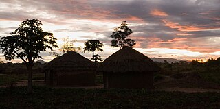
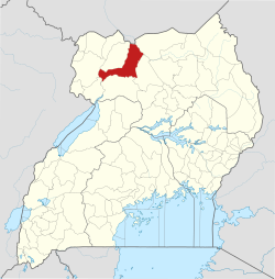
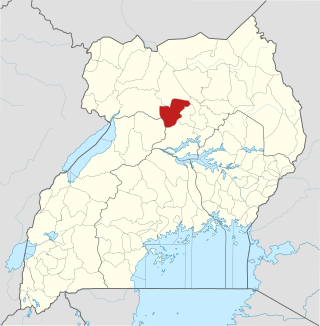
Amuru is a town in the Northern Region of Uganda. It is the main municipal, administrative, and commercial centre of Amuru District.

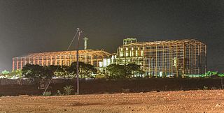
Amuru Sugar Works Limited (ASWL) is a proposed sugar manufacturing company in the Northern Region of Uganda.

<span class="mw-page-title-main">Acholi people</span> Ethnic group of South Sudan and Northern Uganda

The Acholi people are a Nilotic ethnic group of Luo peoples, found in Magwi County in South Sudan and Northern Uganda, including the districts of Agago, Amuru, Gulu, Kitgum, Nwoya, Lamwo, Pader and Omoro District. The Acholi were estimated to number 2.3 million people and over 45,000 more were living in South Sudan in 2000.

Koch-Goma, also Koch Goma, is a human settlement in Nwoya District, in the Northern Region of Uganda.

References

  1. Uganda District Map
  2. "Map Showing Gulu And Amuru With Distance Marker". Globefeed.com. Retrieved 25 May 2014.
  3. Ojok, James Onono (4 March 2014). "Amuru Leaders Concerned With Slow Pace Of Development in The Town Centre". Acholitimes.com. Archived from the original on 25 May 2014. Retrieved 25 May 2014.
  4. "Estimated Population of Amuru District In 1991, 2002 & 2012". Citypopulation.de. Retrieved 24 May 2014.