Kaabong District

Last updated

Kaabong District
Kaabong landscape.jpg
Kaabong District in Uganda.svg
District location in Uganda
Coordinates(Kaabong): 03°32′24″N34°07′30″E / 3.54000°N 34.12500°E / 3.54000; 34.12500
CountryFlag of Uganda.svg  Uganda
Region Northern Region of Uganda
Sub-region Karamoja sub-region
Split from Kotido District 2005
Capital Kaabong
Area
  Land7,223.7 km2 (2,789.1 sq mi)
Highest elevation2,749 m (9,019 ft)
Population
 (2012 Est.)
  Total395,200
  Density54.7/km2 (142/sq mi)
Time zone UTC+3 (EAT)

Kaabong District is a district in the Northern Region of Uganda. The district headquarters are in the similarly named town of Kaabong.

Contents

Location

Kaabong District is bordered by South Sudan to the northwest, Kenya to the northeast and the east, Moroto District to the southeast, Kotido District to the south, and Karenga District to the west. The district headquarters at Kaabong, are approximately 155 kilometres (96 mi), by road, northwest of Moroto, the largest town in the sub-region. [1] In July 2019, the newly formed Karenga District was split off from Kaabong District. [2]

Overview

Kaabong District became functional on 1 July 2005. Prior to that, it was known as Dodoth County in Kotido District. The district is part of the Karamoja sub-region, home to an estimated 1.2 million Karimojong.

Kaabong has two counties: Dodoth East County and Dodoth West County. [3] [4] This is divided into one town council, Kaabong, and thirteen sub-counties: Karenga, Lobalangit, Kawalakol, Kapedo, Lolelia, Lodiko, Kathile, Sidok, Kalapata, Kamion, Kaabong East, Kaabong West and Loyoro. [5]

Geography

Kaabong District has a rocky landscape with hills and valleys. The vegetation is primarily bushes and shrubs. The climatic/weather conditions of Kaabong District are more diverse with various soil types, vegetation and altitudes. There are some areas that contain savannah vegetation, but most of the district is semi-arid with thorny shrubs. There is only one annual season of cultivation. Kidepo Valley National Park is located in the district, 66 kilometres (41 mi), by road, north of the district headquarters at Kaabong. [6]

Population

In 1991, the national population census estimated the population of the district at around 91,200. The 2002 census estimated the population of the district at approximately 202,800. The annual population growth rate in the district, between 2002 and 2012, was 7%. In 2012, it is the population of Kaabong District was estimated at 395,200. [7]

Notable people

See also

Related Research Articles

The Oropom were the aboriginal inhabitants of much of Karamoja in Uganda, Mt. Elgon area and West Pokot, Trans Nzoia and Turkana regions in Kenya. Their descendants were largely assimilated into various communities present in their former territories, including the Iteso, Karamojong, Pokot, Turkana and Bukusu. They are or were found in scattered pockets between the Turkwel River, Chemorongit Mountains and Mt. Elgon. One report indicates that they formerly spoke the unclassified Oropom language.

<span class="mw-page-title-main">Kotido District</span> District in Northern Uganda, Uganda

Kotido District is a district in Northern Uganda. It is named after its 'chief town', Kotido, where the district headquarters are located.

<span class="mw-page-title-main">Moroto District</span> District in Northern Region of Uganda, Uganda

Moroto District is a district in the Northern Region of Uganda. The town of Moroto is the site of the district headquarters.

<span class="mw-page-title-main">Karamojong people</span> Nilotic ethnic group native to northeastern Uganda

The Karamojong or Karimojong are a Nilotic ethnic group. They are agro-pastoral herders living mainly in the north-east of Uganda. Their language is also known as ngaKarimojong and is part of the Nilotic language family. Their population is estimated at 475,000 people.

<span class="mw-page-title-main">Kidepo Valley National Park</span> National park in Uganda

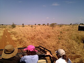
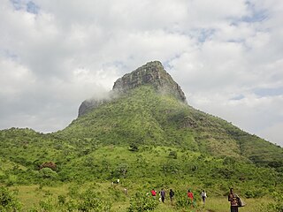
Kidepo Valley National Park is a 1,442 square kilometres (557 sq mi) national park in the Karamoja region in northeast Uganda. Kidepo is rugged savannah, dominated by the 2,750 metres (9,020 ft) Mount Morungole and transected by the Kidepo and Narus rivers.

<span class="mw-page-title-main">Karamoja</span> Sub Region of Uganda

The Karamoja sub-region, commonly known as Karamoja, is a region in Uganda. It covers an area of 27,528km and comprises the Kotido District, Kaabong District, Karenga District, Nabilatuk District, Abim District, Moroto District, Napak District, Amudat District and Nakapiripirit District. The region is projected to have a population of 1.4 millions in 2022 by UBOS.

Kotido is a town in the Northern Region of Uganda. It is the chief municipal, administrative, and commercial center of the Kotido District and the site of the district headquarters.

Nakapiripirit is a town in the Nakapiripirit District of the Northern Region of Uganda. It is the seat of the district headquarters. As an administrative unit of the district, it is one of the eight sub-counties in the district.

<span class="mw-page-title-main">Abim District</span> District in Uganda

Abim District is a district in Northern Uganda. It is named after its 'chief town', Abim, where the district headquarters are located.

Abim is a town in the Northern Region of Uganda. It is the chief municipal, administrative, and commercial center of Abim District. The district is named after the town.

<span class="mw-page-title-main">Kaabong</span> Ugandan town

Kaabong is a town in the Northern Region of Uganda. It is the chief municipal, administrative and commercial center of the eponymous Kaabong District, and the district headquarters are located in the town.

<span class="mw-page-title-main">Alebtong District</span> District in Northern Region of Uganda, Uganda

Alebtong District is a district in the Northern Region of Uganda. The town of Alebtong serves as the district headquarters.

<span class="mw-page-title-main">Amudat District</span> District in Northern Uganda, Uganda

Amudat District is a district in Northern Uganda. Like most Ugandan districts, it is named after its 'chief town', Amudat, where the district headquarters are located.

<span class="mw-page-title-main">Napak District</span> District in Northern Uganda, Uganda

Napak District is a district in Northern Uganda. It is named after Mount Napak, and its headquarters is at Lokitede.

<span class="mw-page-title-main">Jie (Uganda)</span> Ethnic group of Uganda

The Jie are an ethnic group in Uganda. They belong to the Karamojong Cluster, which also includes the Karamojong and Dodoth people. Their country in northeast Uganda lies between the Dodoth to the north and the Karamojong to the south.

Karenga sub-county is a subdivision of Dodoth County in Kaabong District of northern Uganda. Kidepo Valley National Park forms the northern half of the sub-county.

Lorengecora is a settlement in the Northern Region of Uganda. It is the headquarters of Lorengecora Parish, in Iriri sub-county, in Bokora County, in Napak District, in the Karamoja sub-region.

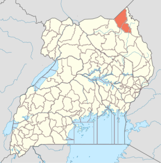
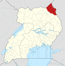
Karenga District is a district in Northern Uganda, in the Karamoja sub-region. The district headquarter is located in Karenga town. It was carved out of Kaabong District and became operational on July 1, 2019. The district has two constituencies: Dodoth West and Napore West. It borders South Sudan and Kaabong District. The population is 84,100, divided over 7 sub-counties and 3 town councils.

Rose Lilly Akello is a Ugandan politician and social worker representing Karenga District as the district woman member of parliament in the eleventh parliament of Uganda. In the ninth and tenth parliament, she served as the district woman member of parliament representing Kaabong District. Rose opted to represent Karenga District instead of Kaabong district because Karenga was carved out of Kaabong on 1 July 2019. She became the Kaabong District Woman MP after winning a by-election in 2017 against Ms Christine Tubo Nakwang. She is affiliated to the ruling political party, NRM.

Kitgum–Kidepo Road is a road in the Northern Region of Uganda, connecting the town of Kitgum in Kitgum District and the town of Apoka, in Kaabong District, inside Kidepo Valley National Park.

References

  1. "Road Distance Between Moroto And Kaabong With Map". Globefeed.com. Retrieved 25 May 2014.
  2. "Preparations in High Gear for New Karenga District". Uganda Radio Network (URN). Retrieved 30 April 2020.
  3. Districts of Uganda, Statoids, accessed 3 August 2015
  4. Counties of Uganda, Statoids, accessed 3 August 2015
  5. "Subcounties in Kaabong District, Uganda". www.lcmt.org. Retrieved 13 February 2022.
  6. "Map Showing Kaabong And Kidepo With Distance Marker". Globefeed.com. Retrieved 25 May 2014.
  7. "Estimated Population of Kaabong District In 1991, 2002 & 2012". Citypopulation.de. Retrieved 25 May 2014.