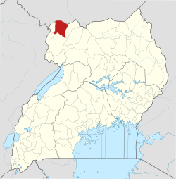
Yumbe District

Last updated
Yumbe District
Yumbe District in Uganda.svg
District location in Uganda
Coordinates: 03°28′N31°15′E / 3.467°N 31.250°E / 3.467; 31.250
CountryFlag of Uganda.svg  Uganda
Region Northern Uganda
Sub-region West Nile sub-region
Capital Yumbe
Area
  Total2,393 km2 (924 sq mi)
Population
 (2012 Estimate)
  Total545,500
  Density228/km2 (590/sq mi)
Time zone UTC+3 (EAT)
Website web.archive.org/web/20090411041051/http://www.yumbe.go.ug:80/

Yumbe District is a district in Northern Region, Uganda. Like most other Ugandan districts, it is named after its 'chief town', Yumbe, where the district headquarters are located.

Contents

Location

Yumbe District is one of Uganda's most northern districts. The district is bordered by South Sudan to the north, Moyo District to the east, Adjumani District to the southeast, Arua District to the south, Maracha District to the southwest and Koboko District to the west. [1] The district headquarters at Yumbe are located approximately 75 kilometres (47 mi), by road, north of Arua, the largest town in the sub-region. [2] The coordinates of the district are:03 28N, 31 15E.

Overview

Yumbe District was established in 2006 when Aringa County was split off Arua District and renamed Yumbe District.The people in the district are still suffering from the effects of the civil war, which lasted about twenty years (1980–2000). The peace agreement between UNRF2 and the Government of Uganda was signed in the year 2000 in Yumbe.

The majority (89%) ethnicity in the district are the Aringa people. Other ethnicities include the Kakwa, Madi and the Alur. The Acholi are scattered along River Nile and mainly engage in fishing and hunting, along the river. They account for about 2% of the district's population.

The languages spoken in the district include: the Aringa language (majority), Kakwa language, Madi language and the Alur language. The second most-spoken language however is Kiswahili. In the urban areas, one might encounter individuals who can understand Arabic or English.

Population

Yumbe is the only district in the country with a mainly Muslim majority population (76%), [3] which is a big exception for Uganda, where 85% of the population is Christians. [4] The fertility rate in the district is high (7.5). [5]

In 1991, the national population census estimated the district population at about 99,800. The 2002 national census estimated the population of the district at about 251,800 inhabitants. The annual population growth rate in Yumbe District was calculated at 8.2%. It was estimated that the population of Yumbe District in 2012 was approximately 545,500. [6]

Means of transport used in yumbe district.

Road transport.

River in yumbe district.

River Kochi.

A river that supplies water for irrigation and household use in Yumbe District. The Kochi River originates in Koboko District, flows through Yumbe District, and enters the Albert Nile in Moyo District. The Kochi River catchment area is one of 12 sub-catchments that make up the Albert Nile Catchment. The catchment area has been degraded by charcoal burning, brick making, and vegetation clearing for agriculture and house construction. The Ministry of Water and Environment is implementing a project to restore 264 kilometers of the Kochi River with funding from the World Bank.

SCHOOLS IN YUMBE DISTRICT

SECONDARY SCHOOLS.

Apo Seed Secondary School
Aringa Secondary School
Ayivu Secondary School
Barakala Secondary School
Bright Star Secondary School Yumbe
Dranjini Hill
Green Valley College
Highland Secondary School
Immaculate Heart College
Kei Seed Secondary School
Kings Modern College,yumbe
Kuru Secondary School
Limidia High School
Lodonga Public Secondary School
Lodonga Seed Secondary School
Loili Secondary School
Lomunga Secondary School
Merwa Progressive College
Midigo Secondary School
Nipata Academy Secondary School
Odravu Secondary School
Romogi Seed Secondary School
St.clare’s Lodonga Girls Ss
Valley View Secondary School
Yoyo Secondary School
Yumbe Secondary School

PRIMARIY SCHOOLS IN YUMBE DISTRSCT

Abiriamajo Primary School
Achilaka Primary School
Acholi Primary School
Adranga Primary School
Agonga Primary School
Akande primary School
Akia Primary School
Alaba Islamic Primary School
Alaba Primary School
Aliapi Primary School
Aliba Primary School
Alinga Primary School
Alligo Primary School
Amaguru Primary School
Ambiya Primary School
Anshwari Primary School
Ariju Model Primary School
Aringa Islamic Primary School
Ariwa Primary School
Awinga Primary School
Awoba Primary School
Ayago Primary School
Ayivu Primary School
Ayivu Ref Settlement Primary School
Banika Islamic Primary School
Barakala Primary School
Bilijia Primary School
Binagoro Primary School
Christ The King Primary School Ariwa
Dondi Primary School
Dracia Hill Islamic Primary School
Dradranga Islamic primary School
Dramba P.7 School
East Alipi Primary School
East Koka Primary School
Eleke Primary School
Fataha Primary School
Galaba P.7 School
Geya Primary School
Gichara Primary School
Goboro Primary School
Gojuru Primary School
Govule Islamic Primary School
Highland Primary School
Hilalitopio Primary School
Hillttop Primary School Limu
Hope Primary School
Imvenga Primary School
Inia Primary School
Iyete Primary School
Jalata Primary School
Kado Primary School
Kanabu Hill Primary School
Kechuru Primary School
Kejebere Primary School
Kenga Valley Primary School
Kenyanga Primary School
Kerwa Primary School
Keyi P.7 School
Kilaji Primary School
Kisimunga Primary School
Knowledge Land Primary School
Kochi Bridge Primary School
Kodejje Primary School
Koka Primary School
Komgbe Primary School
Koro Highland Primary School
Kubali Primary School
Kulikulinga Islamic primary School
Kulinga Primary School
Kululu Primary School
Kumia Primary School
Kumuna Primary School
Kuru Islamic Primary School
Kuru Primary School
Lamgba Primary School
Langi Primary School
Legu primary School
Limidia Primary School
Lobe P.7 School
Locomgbo Primary School
Lodenga Primary School
Lodonga Black Primary School
Lodonga Demo. School
Lodonga Girls’ Primary School
Logoa Primary School
Lokopio Primary School
Lombe Primary School
Lomorojo Primary School
Lomunga Primary School
Lukutua Primary School
Luzira Bright View Primary School
Manibe Islamic Primary School
Matu Primary School
Matuma Primary School
Mengo Primary School
Menzere Primary School
Mgbilinji Primary School
Midigo Calvary Primary School
Midigo Primary School
Mijale Primary School
Mijikita Primary School
Moli Primary School
Molondo Bright Primary School
Mongoyo Primary School
Mulumbe Primary School
Munir Primary School
Naku Primary School
Nipata Valley Primary School
Nyoko Kobo Primary School
Nyoko Primary School
Nyori P.7 School
Obero Primary School
Obero West Primary School
Odravu Primary School
Odropi Primary School
Ofonze Primary School
Ojinga Primary School
Okoi Primary School
Okuvuru Primary School
Okuyo Primary School
Olivu primary School
Oluba Primary School
Omba Primary School
Ombechi Primary School
Ombetiku Cope
Omgbokolo Primary School
Oniku P.7 School
Oria Primary School
Osubira Village Primary School
Paduru Primary School
Pajama P.7 School
Pakayo Primary School
Para Primary School
Peace Primary School
Rembeta Primary School
Rimbe Primary School
Rock City Primary School
Rockland Primary School
Salam Primary School
St. Catherine Primary School
St. Daniel Comboni Primary School
Swinga Primary School
Takwa Primary School
Tokuro Primary School
Tuliki Primary School
Twajiji Hope Primary School
Twajiji Primary School
Universal Primary School
Urungu Primary School
Wetikoro Primary School
Wolo Primary School
Yangani Progrssive Primary School
Yiba Parents Primary School
Yoyo Central Primary School
Yoyo Primary School
Yumbe Calvary Primary School
Yumbe Primary School

NURSERY SCHOOLS IN YUMBE DISTRICT

ECONOMIC ACTIVITIES

Subsistence agriculture is the main economic activity in the district, as is the case with most Ugandan districts. Crops grown include the following: [7]

See also

Related Research Articles

<span class="mw-page-title-main">Arua District</span> District in Northern Uganda, Uganda

Arua District is a district in the Northern Region of Uganda. Like many Ugandan districts, it too shares its name with its administrative center of Arua. The name Arua is said to be derived from the Lugbara name for prison (Arujo) and prisoner (Aru), since the white settlers had a detention center at Arua Hill.

<span class="mw-page-title-main">Moyo District</span> District in Northern Uganda, Uganda

Moyo District is a district in Northern Region of Uganda. Like many other Ugandan districts, it is named after its "chief town", Moyo, where the district headquarters are located.

<span class="mw-page-title-main">Nebbi District</span> District in Northern Uganda, Uganda

Nebbi District is a district in Northern Uganda. It is named after its main municipal, commercial and administrative centre, Nebbi, the location of the district headquarters.

<span class="mw-page-title-main">Arua</span> Place in Northern Region, Uganda

Arua is a city and commercial centre within the Arua District in the Northern Region of Uganda.

<span class="mw-page-title-main">Koboko District</span> District in Northern Region of Uganda, Uganda

Koboko District is a district in the Northern Region of Uganda. The town of Koboko is the site of the district headquarters.

<span class="mw-page-title-main">West Nile sub-region</span>

West Nile sub-region, previously known as West Nile Province and West Nile District, is a sub-region in north-western Uganda, in the Northern Region of Uganda.

<span class="mw-page-title-main">Lugbara people</span> Central Sudanic ethnic group

The Lugbara are a Central Sudanic ethnic group who live primarily in the West Nile region of Uganda, in the adjoining area of the Democratic Republic of the Congo (DRC) with a few living in South Sudan. They speak the Lugbara language, a Central Sudanic language similar to the language spoken by the Madi, with whom they also share many cultural similarities.

Yumbe is a town in the Northern Region of Uganda. It is the district headquarters of Yumbe District.

Moyo, is the main municipal, administrative, and commercial center of Moyo District in the Northern Region of Uganda. The district headquarters are located here.

Koboko is a town in Northern Region of Uganda. It is the main municipal, administrative, and commercial centre of Koboko District. Koboko is also the hometown of former dictator Idi Amin who ruled Uganda from 1971 to 1979.

The Aringa are a Central Sudanic ethnic group primarily residing in the rural areas of Yumbe District, located in the northwestern corner of Uganda. They are also found in other regions of the West Nile sub-region. The Aringa people are considered the indigenous inhabitants of their lands, which were later settled by a group known as the "Nubians." Their language, also called Aringa, belongs to the Central Sudanic language family. According to the 2014 Census of Uganda the Aringa numbered 494,626 people.

The Moru–Madi languages of the Central Sudanic language family are a cluster of closely related languages spoken in South Sudan, the Democratic Republic of Congo, and Uganda. Moru is spoken by 100,000 people, and Ma'di is spoken by twice that number. The most populous languages are Aringa of Uganda, with close to a million speakers, and Lugbara, with 1.6 million.

<span class="mw-page-title-main">Maracha District</span> District in Northern Region, Uganda

Maracha District is a district in the West Nile sub-region, in the Northern Region of Uganda. It was formed in 2006 from Arua District.

Agofe is the noble title for the chief cultural leader among all the Lugbara people or King of Lado Kingdom which covers the regions of West Nile, Ituri, Torit, Uele and Yei. The term means 'Pillar' or 'Paramount Chief' but a king is also called opi in Lugbara; an opi is usually the clan leader of a lineage. Around 1967, President Milton Obote abolished kingdoms, then the 1995 Constitution reinstated cultural institutions but the Lugbara only chose county chiefs. In 2012, the Government of Uganda finally recognised this revised Agofe institution. The Agofe's duty will be to preserve Lugbara culture through literature and other assignments.

West Nile Cup is the annual football tournament contested by the political districts in the West Nile sub-region of Uganda. The tournament was started in 2012 by Lawrence Mulindwa, a year before he ceased to be the president of the Federation of Uganda Football Associations, Uganda's football-governing body. The first edition was hosted by Arua and it was organised to bring West Nile together. The other mission is to identify talent for inter-region tournaments like Airtel Under 17, which can also be a backup wellspring for the Uganda Cranes, the nickname for the national team.

The Koboko–Yumbe–Moyo Road is a road in the Northern Region of Uganda, connecting the towns of Koboko, Yumbe, and Moyo.

<span class="mw-page-title-main">Bidibidi Refugee Settlement</span> Place in Yumbe, Uganda

Bidibidi Refugee Settlement is a refugee camp in the Yumbe District of northwestern Uganda. Home to over 270,000 South Sudanese refugees fleeing the ongoing civil war in mid 2016, it was among the largest refugee settlements in the world at the time, and may have been the largest. As of 2018, that distinction was claimed by Kutupalong refugee camp for displaced Rohingya in Bangladesh.

Lodonga is a town in the Northern Region of Uganda. It is one of the municipalities in Yumbe District.

Charles Collins Andaku is an Anglican bishop in Uganda: he has been the Bishop of Madi and West Nile since 2017.

<span class="mw-page-title-main">Terego District</span> District in Northern, Uganda

Terego is a district in Uganda's Northern Region. It is located approximately 360 kilometres (220 mi) northwest of Uganda's capital Kampala. The administrative centre of the district is the trading centre of Leju in Aii-Vu Sub-County. Terego District covers an area of 1,102 square kilometres (425 sq mi) and the areas now making up the district recorded a non-refugee population of 199,303 in the 2014 Ugandan census. Terego District also hosts an estimated 168,000 refugees, mostly from South Sudan, in the Imvepi Refugee Settlement and the western zones of the Rhino Camp Refugee Settlement in the district.

References

  1. Uganda District Map
  2. "Map Showing Arua And Yumbe With Distance Marker". Globefeed.com. Retrieved 22 May 2014.
  3. "Self-Reported Religious Affiliations of Ugandans In 2002, By District" (PDF). Uganda Bureau of Statistics. 2002. Retrieved 22 May 2014.
  4. Census 2014 Final Results
  5. "Population Dynamics of Ugandans In 2002, By District" (PDF). Uganda Bureau of Statistics. Retrieved 22 May 2014.
  6. "Estimated Population of Yumbe District In 1991, 2002 & 2012". Citypopulation.de. Retrieved 22 May 2014.
  7. "Profile of Yumbe District". Uganda Travel Guide. Retrieved 22 May 2014.