Kitagwenda District

Last updated

Kitagwenda District
Kamwenge District in Uganda.svg
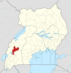
District location in Uganda
Coordinates: 00°01′43″S30°20′10″E / 0.02861°S 30.33611°E / -0.02861; 30.33611
CountryFlag of Uganda.svg  Uganda
Region Western Uganda
Sub-region Toro sub-region
Capital Ntara
Government
  LCV ChairmanRobert Mugabe [1]
Population
 (2014 Census)
  Total165,354
Time zone UTC+3 (EAT)
Website www.kitagwenda.go.ug

Kitagwenda District is a district in Western Uganda. The district is named after Kitagwenda County, which is coterminous with the district. [2]

Contents

Kitagwenda District is part of the Kingdom of Toro, one of the ancient traditional monarchies in Uganda. The kingdom is coterminous with the Toro sub-region, home to an estimated 1 million inhabitants in 2002, according to the national population and housing census conducted that year. The districts that constitute the sub-region are: (a) Bunyangabu District (b) Kabarole District (c) Kamwenge District (d) Kyegegwa District (e) Kyenjojo District and (f) Kitagwenda District. [3]

Location

Kitagwenda District is bordered by Kabarole District to the northwest and north, Kamwenge District to the northeast, Ibanda District to the east and southeast, Rubirizi District to the southwest and Kasese District to the west. [4]

Ntara, the district headquarters lies approximately 100 kilometres (62 mi), by road, south of Fort Portal, the largest city in Toro sub-region. [5] This is 340 kilometres (211 mi), by road, west of Uganda's capital city, Kampala. [6] The coordinates of Kitagwenda District are: 0°01'43.0"S, 30°20'10.0"E (Latitude:-0.028611; Longitude:30.336111). [7]

Overview

The district was created in 2019 by an Act of Parliament. Prior to then, it was part of Kamwenge District. The district is coterminous with Kitagwenda County, after which it is named. [1] It is predominantly a rural area district. [8]

Kitagwenda is made up of one county, two town councils and five sub-counties. The town councils are Ntara and Kabujogera. The sub-counties are Nyabbani, Ntara, Kanara, Kicheche and Mashyoro. [1]

There are numerous aquatic systems in the district including:

Population

The 2011, the population of Kitagwenda County was estimated at 129,600 inhabitants. [9] The national population census and household survey held on 27 August 2014, enumerated the population of Kitagwenda at 165,354 people. [1] The predominant ethnic group in the district are Batagwenda and the language spoken is Rutagwenda.

See also

Related Research Articles

<span class="mw-page-title-main">Kabarole District</span> District in Western Uganda, Uganda

Kabarole District is a district in Western Uganda. Kabarole District is part of the Tooro Kingdom. Its main town was Fort Portal before 1 July 2020 when it was elevated to a city, separating it from Kabarole district. The new Kabarole district seat is proporsed in Busoro Town Council. Kabarole remains with only one county (Burahya). Bunyangabu county was curved out to form Bunyangabu district in 2017. Fort Portal Municipality constituency became Fort Portal City in 2020 with an independent local Government.

<span class="mw-page-title-main">Kamwenge District</span> District in Western Uganda, Uganda

Kamwenge District is a district in Western Uganda. It is named after its 'chief town', Kamwenge, where the district headquarters are located. Kamwenge District is part of the Kingdom of Toro, one of the ancient traditional monarchies in Uganda. The kingdom is coterminous with Toro sub-region. The districts that constitute the sub-region are: (a) Bunyangabu District (b) Kabarole District (c) Kamwenge District (d) Kyegegwa District (e) Kitagwenda District and (f) Kyenjojo District.

<span class="mw-page-title-main">Kasese District</span> District in Western Uganda, Uganda

Kasese District is a district in Western Uganda. Like most other Ugandan districts, it is named after its chief town and district headquarters, the town of Kasese.

<span class="mw-page-title-main">Kibaale District</span> District in Western Region, Uganda

Kibaale District, is a district in the Western Region of Uganda. The district headquarters are in the town of Kibaale.

<span class="mw-page-title-main">Kyenjojo District</span> District in Western Region of Uganda, Uganda

Kyenjojo District is a district in the Western Region of Uganda. Kyenjojo town is the site of the district headquarters.

<span class="mw-page-title-main">Fort Portal</span> Place in Western Region, Uganda

Fort Portal or Kabarole is a city located in the Western Region of Uganda. It is the seat of both Kabarole District and historically of the Tooro Kingdom.

Kamwenge is a town in the Western Region of Uganda. It is the site of the Kamwenge District headquarters.

<span class="mw-page-title-main">Kiruhura District</span> District in Western Region, Uganda

Kiruhura District is a district in the Western Region of Uganda. The town of Rushere is the site of the district headquarters.

Kijura is a town in Kabarole District, in the Western Region of Uganda.

<span class="mw-page-title-main">Kyegegwa District</span> District in Western Region, Uganda

Kyegegwa District is a district in Western Region of Uganda. The town of Kyegegwa hosts the district headquarters.

Mpanga is a location on River Mpanga in Kitagwenda county, Kitagwenda District in Western Uganda.

The Nyakahita–Kazo–Kamwenge–Fort Portal Road is a road in the Western Region of Uganda, connecting the towns of Nyakahita and Kazo in Kiruhura District, Ibanda in Ibanda District, Kamwenge in Kamwenge District, and Fort Portal in Kabarole District.

Nyakahita is a sparsely populated settlement in the Western Region of Uganda.

Kazo is a town in the Western Region of Uganda. It is the capital of Kazo District.

Bunyangabu District is a district in the Western Region of Uganda. The town of Kibiito is the political and administrative center of the district. However, the town of Rwimi, is the largest and main commercial center of Bunyangabu.

Kibiito is a town in the Western Region of Uganda. It is the chief administrative center of Bunyangabu District, and the district headquarters are located there.

Rubona is a town in the Western Region of Uganda.

Bihanga is a settlement in Ibanda District in the Western Region of Uganda. It is the location of the headquarters of Bihanga Parish, Nyamarebe sub-county.

Ntara is a settlement in Kitagwenda District, in Western Uganda. It is the political, administrative and commercial headquarters of the district. Ntara is one of the two municipalities in the newly-created Kitagwenda District, the other being Kabujogera Town Council.

Kabujogera is a settlement in Kitagwenda District, in Western Uganda. It is one of the two municipalities in the newly created Kitagwenda District, the other being Ntara Town Council, where the district headquarters are located.

References

  1. 1 2 3 4 Lawrence Mucunguzi (25 July 2019). "Robert Mugabe elected Kitagwenda Interim District Chairperson". New Vision . Kampala. Retrieved 28 November 2019.
  2. The Edge Reporter (29 June 2019). "Kamwenge Finally Lets Go of New Kitagwenda District". Kampala: The Edge Uganda. Retrieved 28 November 2019.
  3. Uganda Farmers Guide (2019). "View Farmers Groups in Toro Sub Region". Uganda Farmers Guide. Retrieved 28 November 2019.
  4. Uganda District Map
  5. Globefeed.com (28 November 2019). "Distance between Fort Portal, Kabarole, Uganda and Ntara, Kitagwenda, Uganda". Globefeed.com. Retrieved 28 November 2019.
  6. Globefeed.com (28 November 2019). "Distance between Kampala, Uganda and Ntara, Kitagwenda, Uganda". Globefeed.com. Retrieved 28 November 2019.
  7. Google (28 November 2019). "Location of Kitagwenda District, Western Region, Uganda" (Map). Google Maps . Google. Retrieved 28 November 2019.
  8. Uganda Travel Guide (2014). "Profile of Kamwenge District". Kampala: Uganda Travel Guide. Retrieved 28 November 2019.
  9. Joshua Nahamya (22 January 2019). "Kamwenge LCV Chairman Calls For Cohesion As District Split Nears Fruition". Kampala: SoftPower Uganda. Retrieved 28 November 2019.