Bartlett, Ohio

Last updated

Location of Bartlett, Ohio OHMap-doton-Bartlett.png
Location of Bartlett, Ohio
Houses along State Route 550 Bartlett houses on 550.jpg
Houses along State Route 550

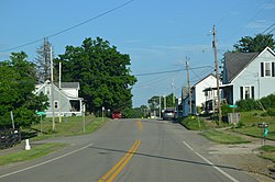
Bartlett is an unincorporated community in southwestern Wesley Township, Washington County, Ohio, United States. [1] It has a post office with the ZIP code 45713. [2] It sits at the intersection of State Routes 550 and 555 near Coal Run, a subsidiary of Wolf Creek, which meets the Muskingum River at Waterford to the north. [3] Near Bartlett is located the Shinn Covered Bridge, which spans Wolf Creek. [4]

History

Bartlett was laid out in 1832. [5] A post office called Bartlett has been in operation since 1834. [6] Amos Bartlett, the first postmaster, gave the community his name. [7]

Related Research Articles

Fleming is a small unincorporated community in rural eastern Barlow Township, Washington County, Ohio, United States.

<span class="mw-page-title-main">Lees Creek, Ohio</span> Unincorporated community in Ohio, U.S.

Lees Creek, also known as Centerville, is an unincorporated community in central Wayne Township, Clinton County, Ohio, United States. It lies at the intersection of State Route 729 with Cox Road, 6 miles south of Sabina and 12 miles (19 km) southeast of Wilmington, the county seat of Clinton County. It lies between the headwaters of the Middle Fork of Lees Creek, to the southeast, and the Anderson Fork of Caesar Creek. it had a post office, with the ZIP code 45138. The Post Office closed in 2012 and the town, including East Clinton High School, now carries a Sabina mailing address.

<span class="mw-page-title-main">Decatur, Ohio</span> Unincorporated community in Ohio, U.S.

Decatur is an unincorporated community in eastern Byrd Township, Brown County, Ohio, United States. It has a post office with the ZIP code 45115. It is located along State Route 125, an east-west highway.

<span class="mw-page-title-main">Cuba, Clinton County, Ohio</span> Unincorporated community in Ohio, US

Cuba is an unincorporated community in western Washington Township, Clinton County, Ohio, United States. It has a post office with the ZIP code 45114. It lies at the intersection of U.S. Route 68 with State Route 350. In addition to the post office, the community is home to the Cuba Friends Meeting, a part of the Wilmington Yearly Meeting of the Society of Friends.

<span class="mw-page-title-main">Wolf Run, Ohio</span> Unincorporated community in Ohio, U.S.

Wolf Run is an unincorporated community in eastern Springfield Township, Jefferson County, Ohio, United States. It has a post office with the ZIP code 43970. The stream of Wolf Run, which flows northward past the community, is a tributary of Goose Creek, which in turn flows southward to meet Cross Creek in Harrison County's German Township, which in turn flows eastward to meet the Ohio River at Mingo Junction.

<span class="mw-page-title-main">Stewart, Ohio</span> Census-designated place in Ohio, United States

Stewart is an unincorporated community and census-designated place in central Rome Township, Athens County, Ohio, United States. The population was 221 at the 2020 census. It has a post office with the ZIP code 45778.

<span class="mw-page-title-main">Guysville, Ohio</span> Unincorporated community in Ohio, U.S.

Guysville is an unincorporated community in southern Rome Township, Athens County, Ohio, United States. It has a post office with the ZIP code 45735.

<span class="mw-page-title-main">Wingett Run, Ohio</span> Unincorporated community in Ohio, U.S.

Wingett Run is an unincorporated community in western Ludlow Township, Washington County, Ohio, United States. It has a post office with the ZIP code 45789. It is located along State Route 26 and the Little Muskingum River.

<span class="mw-page-title-main">Whipple, Ohio</span> Unincorporated community in Ohio, U.S.

Whipple is an unincorporated community in southern Salem Township, Washington County, Ohio, United States. Although it is unincorporated, it once had a post office, with the ZIP code 45788. It lies on State Route 821 south of the village of Lower Salem, at the junction of Whipple Run with Duck Creek. The community took its name from nearby Whipple Run.

<span class="mw-page-title-main">Watertown, Ohio</span> Unincorporated community in Ohio, U.S.

Watertown is an unincorporated community in southwestern Watertown Township, Washington County, Ohio, United States. It has a post office with the ZIP code 45787. It lies near the intersection of State Routes 339 and 676 near Wolf Creek, which meets the Muskingum River at Waterford to the north.

<span class="mw-page-title-main">Cutler, Ohio</span> Unincorporated community in Ohio, U.S.

Cutler is an unincorporated community in southwestern Fairfield Township, Washington County, Ohio, United States. It has a post office with the ZIP code 45724. It lies at the intersection of State Route 555 and County Road 59 near Gilbert Run, a subsidiary of the Little Hocking River, which meets the Ohio River at Little Hocking to the southeast.

<span class="mw-page-title-main">Barlow, Ohio</span> Unincorporated community in Ohio, U.S.

Barlow is an unincorporated community in western Barlow Township, Washington County, Ohio, United States. Although it is unincorporated, it has a ZIP code 45712. It lies at the intersection of State Routes 339 and 550 near the South Fork of Wolf Creek, which meets the Muskingum River at Waterford to the north.

<span class="mw-page-title-main">White Cottage, Ohio</span> Unincorporated community in Ohio, U.S.

White Cottage is an unincorporated community in central Newton Township, Muskingum County, Ohio, United States. It has a post office with the ZIP code 43791. It lies along U.S. Route 22 between Zanesville and Lancaster.

<span class="mw-page-title-main">Chandlersville, Ohio</span> Unincorporated community in Ohio, U.S.

Chandlersville is an unincorporated community in western Salt Creek Township, Muskingum County, Ohio, United States. It has a post office with the ZIP code 43727. It lies along State Route 146 at its intersection with State Routes 284 and 313.

Schwertner is an unincorporated community in Williamson County, Texas, United States. It is approximately 28 miles north-northeast of Round Rock. Schwertner has a post office, with the ZIP code 76573.

<span class="mw-page-title-main">Conotton, Ohio</span> Unincorporated community in Ohio, US

Conotton is an unincorporated community in North Township, Harrison County, Ohio, United States. The community is serviced by the Bowerston post office, ZIP Code 44695. It is located near Conotton Creek, State Route 151 and the Wheeling and Lake Erie Railway. According to the GNIS the community has also been known as Masterville.

Finland is a village and an unincorporated community on the Unami Creek in southern Milford Township, Bucks County, Pennsylvania, United States. It is split between the Green Lane Zip Code of 18054 and the Pennsburg zip code of 18073. The immediate area was known in the 1920s as the "Poconos of Philadelphia" and as "The Fineland," and it is from this latter name that the US post office had put it on the map as Finland in 1886. Multiple summer camps have been located in this area and one of them is still in use. The Unami Creek flows southward to the Perkiomen Creek. The village was established by Finnish immigrants to New Sweden.

Patten Mills is an unincorporated community in Washington County, in the U.S. state of Ohio.

Rainbow is an unincorporated community in Washington County, in the U.S. state of Ohio.

Wolf Creek is an unincorporated community in Washington County, in the U.S. state of Ohio.

References

  1. U.S. Geological Survey Geographic Names Information System: Bartlett, Ohio
  2. Zip Code Lookup Archived September 26, 2007, at the Wayback Machine
  3. DeLorme, Ohio Atlas & Gazetteer, 7th ed., 2004, pp. 71, 80, 81 ISBN   0-89933-281-1
  4. Owen, Lorrie K. ed., Dictionary of Ohio Historic Places, Vol. 2, St. Clair Shores, Somerset, 1999, p.1399
  5. "How communities got their names". Marietta Times. February 19, 2013. Retrieved December 29, 2015.
  6. "Washington County". Jim Forte Postal History. Retrieved December 29, 2015.
  7. History of Washington County, Ohio: With Illustrations and Biographical Sketches. H.Z. Williams. 1881. p. 724.

39°25′10″N81°48′56″W / 39.41944°N 81.81556°W / 39.41944; -81.81556