Devola, Ohio

Last updated
Devola, Ohio
CDP
OHMap-doton-Devola.png
Location of Devola, Ohio
Detailed map of Devola, Ohio.png
Detailed map of Devola
Coordinates: 39°28′35″N81°29′03″W / 39.47639°N 81.48417°W / 39.47639; -81.48417
Country United States
State Ohio
County Washington
Area
[1]
  Total5.40 sq mi (13.98 km2)
  Land5.13 sq mi (13.30 km2)
  Water0.26 sq mi (0.68 km2)
Elevation
[2]
646 ft (197 m)
Population
 (2020)
  Total2,639
  Density513.92/sq mi (198.44/km2)
Time zone UTC-5 (Eastern (EST))
  Summer (DST) UTC-4 (EDT)
FIPS code 39-21868 [3]
GNIS feature ID2393396 [2]

Devola is a census-designated place (CDP) in Washington County, Ohio, United States, along the Muskingum River. It is part of the Parkersburg-Marietta-Vienna, WV-OH Metropolitan Statistical Area. The population was 2,639 at the 2020 census.

Contents

History

The community was named for the local Devol family. [4] Captain Devol built a mill in 1807 at Devol's Dam. [5] A post office called Devols Dam was established in 1881, and remained in operation until 1890. [6]

Geography

According to the United States Census Bureau, the CDP has a total area of 5.4 square miles (14 km2), of which 5.1 square miles (13 km2) is land and 0.2 square miles (0.52 km2) (4.10%) is water.

Education

Devola had one school local to the region, Putnam Elementary School. The school ceased operation in 2020 due to budget cuts of the Marietta City School District. [7] Further education is available in nearby towns, including:

Demographics

Historical population
CensusPop.Note
2020 2,639
U.S. Decennial Census [8]

At the 2000 census there were 2,771 people, 1,065 households, and 803 families living in the CDP. The population density was 539.9 inhabitants per square mile (208.5/km2). There were 1,136 housing units at an average density of 221.4 per square mile (85.5/km2). The racial makeup of the CDP was 97.58% White, 0.07% African American, 1.88% Asian, 0.07% from other races, and 0.40% from two or more races. Hispanic or Latino of any race were 0.11%. [3]

Of the 1,065 households 28.6% had children under the age of 18 living with them, 68.2% were married couples living together, 6.3% had a female householder with no husband present, and 24.6% were non-families. 22.1% of households were one person and 12.2% were one person aged 65 or older. The average household size was 2.46 and the average family size was 2.88.

The age distribution was 22.4% under the age of 18, 6.1% from 18 to 24, 22.4% from 25 to 44, 26.9% from 45 to 64, and 22.2% 65 or older. The median age was 44 years. For every 100 females there were 93.1 males. For every 100 females age 18 and over, there were 88.3 males.

The median household income was $48,558 and the median family income was $58,214. Males had a median income of $39,028 versus $26,833 for females. The per capita income for the CDP was $24,751. About 3.4% of families and 4.5% of the population were below the poverty line, including 7.8% of those under age 18 and 4.8% of those age 65 or over.

Related Research Articles

<span class="mw-page-title-main">Washington County, Ohio</span> County in Ohio, United States

Washington County is a county located in the southeastern part of the U.S. state of Ohio. As of the 2020 census, the population was 59,711. Its county seat is Marietta. The county, the oldest in the state, is named for George Washington. Washington County comprises the Marietta, OH Micropolitan Statistical Area, which is also included in the Parkersburg-Marietta-Vienna, WV-OH Combined Statistical Area.

<span class="mw-page-title-main">Lakewood Shores, Illinois</span> Census-designated place in Illinois, United States

Lakewood Shores is a census-designated place (CDP) in Will County, Illinois, United States. The population was 665 at the 2020 census.

<span class="mw-page-title-main">Massac, Kentucky</span> Census-designated place in Kentucky, United States

Massac is a census-designated place (CDP) in McCracken County, Kentucky, United States. The population was 4,635 at the 2020 census. It is part of the Paducah, KY-IL Metropolitan Statistical Area.

<span class="mw-page-title-main">Glen Head, New York</span> Hamlet and census-designated place in New York, United States

Glen Head is a hamlet and census-designated place (CDP) located within the Town of Oyster Bay in Nassau County, on the North Shore of Long Island, in New York, United States. It is considered part of the greater Glen Cove area, which is anchored by the City of Glen Cove. The population was 4,837 at the 2020 census.

<span class="mw-page-title-main">Forest Oaks, North Carolina</span> Census-designated place in North Carolina, United States

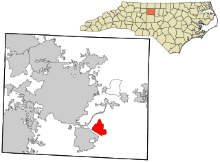
Forest Oaks is a census-designated place (CDP) in Guilford County, North Carolina, United States. The population was 3,890 as of the 2010 census, up from 3,241 in 2000.

<span class="mw-page-title-main">Covedale, Ohio</span> Census-designated place in Ohio, United States

Covedale is a census-designated place (CDP) in Green Township, Hamilton County, Ohio, United States. The population was 6,472 at the 2020 census. The CDP represents the part of the former village of Covedale that was not annexed by the city of Cincinnati in the 1890s.

<span class="mw-page-title-main">Groesbeck, Ohio</span> Census-designated place in Ohio, United States

Groesbeck is a census-designated place (CDP) in Hamilton County, Ohio, United States. The population was 7,365 at the 2020 census. It is a suburb of Cincinnati.

<span class="mw-page-title-main">Northgate, Ohio</span> Census-designated place in Ohio, United States

Northgate is a census-designated place (CDP) in Colerain Township, Hamilton County, Ohio, United States. The population was 7,277 at the 2020 census.

<span class="mw-page-title-main">Pleasant Run, Ohio</span> Census-designated place in Ohio, United States

Pleasant Run is a census-designated place (CDP) in Colerain Township, Hamilton County, Ohio, United States. The population was 4,861 at the 2020 census.

<span class="mw-page-title-main">Sherwood, Hamilton County, Ohio</span> Census-designated place in Ohio, United States

Sherwood is a census-designated place (CDP) in Hamilton County, Ohio, United States. The population was 3,633 at the 2020 census.

<span class="mw-page-title-main">White Oak, Ohio</span> Census-designated place in Ohio, United States

White Oak is a census-designated place (CDP) in Hamilton County, Ohio, United States. It is seven miles northwest of Cincinnati. The population was 19,541 at the 2020 census. White Oak is situated in both Green Township and Colerain Township.

<span class="mw-page-title-main">Gibsonburg, Ohio</span> Village in Ohio, United States

Gibsonburg is a village in Sandusky County, Ohio, United States, about 33 miles (53 km) southeast of Toledo. The population was 2,452 at the 2020 census. The National Arbor Day Foundation has designated Gibsonburg as a Tree City USA.

<span class="mw-page-title-main">Rosemount, Ohio</span> Census-designated place in Ohio, United States

Rosemount is a census-designated place (CDP) in Clay Township, Scioto County, Ohio, United States. The population was 2,117 at the 2020 census.

<span class="mw-page-title-main">West Portsmouth, Ohio</span> Census-designated place in Ohio, United States

West Portsmouth is a census-designated place (CDP) in Scioto County, Ohio, United States. The population was 2,929 at the 2020 census.

<span class="mw-page-title-main">West Hill, Ohio</span> Census-designated place in Ohio, United States

West Hill is an unincorporated community and census-designated place in eastern Brookfield Township, Trumbull County, Ohio, United States. The population was 2,218 at the 2020 census. It is part of the Youngstown–Warren metropolitan area.

<span class="mw-page-title-main">Marietta, Adair County, Oklahoma</span> Census-designated place in Oklahoma, United States

Marietta is a census-designated place (CDP) in Adair County, Oklahoma, United States. The population was 106 at the 2010 census. The community was listed as Maryetta at the 2000 census, at which time it had a population of 138.

<span class="mw-page-title-main">Hudson Bend, Texas</span> CDP in Texas, United States

Hudson Bend is a census-designated place (CDP) in Travis County, Texas, United States. The population was 4,005 at the 2020 census.

<span class="mw-page-title-main">Mount Gay-Shamrock, West Virginia</span> Census-designated place in West Virginia, United States

Mount Gay-Shamrock is a census-designated place (CDP) in Logan County, West Virginia, United States.

<span class="mw-page-title-main">Washington, West Virginia</span> CDP in West Virginia, United States

Washington is a census-designated place (CDP) in Wood County, West Virginia, United States, situated along the Ohio River. It is part of the Parkersburg-Marietta-Vienna, WV-OH Metropolitan Statistical Area. The population was 1,175 at the 2010 census. The community was named after George Washington.

<span class="mw-page-title-main">Potter Lake, Wisconsin</span> CDP in Wisconsin, United States

Potter Lake is a census-designated place (CDP) in the town of East Troy, Walworth County, Wisconsin, United States. The population was 1,117 at the 2020 census.

References

  1. "ArcGIS REST Services Directory". United States Census Bureau. Retrieved September 20, 2022.
  2. 1 2 U.S. Geological Survey Geographic Names Information System: Devola, Ohio
  3. 1 2 "U.S. Census website". United States Census Bureau . Retrieved 2008-01-31.
  4. U.S. Geological Survey Geographic Names Information System: Devola, Ohio
  5. Hathaway, Seymour J. (1902). History of Marietta and Washington County, Ohio, and Representative Citizens. Biographical Publishing Company. p.  316.
  6. "Washington County". Jim Forte Postal History. Archived from the original on 18 January 2016. Retrieved 29 December 2015.
  7. "Explore Putnam Elementary School in Marietta, OH". GreatSchools.org. Retrieved 2020-07-16.
  8. "Census of Population and Housing". Census.gov. Retrieved June 4, 2016.