Beniapukur

Last updated

Beniapukur
Neighbourhood in Kolkata (Calcutta)
Nonapukur depot2.jpg
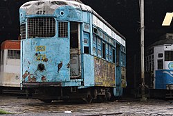
Nonapukur Tram Depot, Beniapukur
Kolkata location map EN.svg
Red pog.svg
Beniapukur
Location in Kolkata
Coordinates: 22°32′47″N88°22′10″E / 22.546333°N 88.369525°E / 22.546333; 88.369525
CountryFlag of India.svg  India
State West Bengal
City Kolkata
District Kolkata
Metro Station Close to Rabindra Sadan, Close to Maidan, Close to Park Street, Close to Sealdah(under construction) and Close to Barun Sengupta(under construction)
Municipal Corporation Kolkata Municipal Corporation
KMC wards 59, 60, 61
Population
  TotalFor population see linked KMC ward page
Time zone UTC+5:30 (IST)
PIN
700014
Area code +91 33
Lok Sabha constituency Kolkata Dakshin
Vidhan Sabha constituency Ballygunge

Beniapukur is a neighbourhood of Central Kolkata in Kolkata district in the Indian state of West Bengal. It is adjacent to Park Circus.

Contents

Etymology

The name of the neighbourhood is derived from two words, benia and pukur. Influential benias or merchants, particularly gandhabaniks, perfume and spice traders, settled here. They had dug a tank or pukur in the area. [1]

History

The East India Company obtained from the Mughal emperor Farrukhsiyar, in 1717, the right to rent from 38 villages surrounding their settlement. Of these 5 lay across the Hooghly in what is now Howrah district. The remaining 33 villages were on the Calcutta side. After the fall of Siraj-ud-daulah, the last independent Nawab of Bengal, it purchased these villages in 1758 from Mir Jafar and reorganised them. These villages were known en-bloc as Dihi Panchannagram and Beniapukur was one of them. [2] [3] [1]

The Maratha Ditch was dug in 1742 and it was partly filled up in 1799 to create the Circular Road (now Acharya Jagaidsh Chandra Bose Road). [1]

Entally, Maniktala, Beliaghata, Ultadanga, Chitpur, Cossipore, parts of Beniapukur, Ballyganj, Watganj and Ekbalpur, and parts of Garden Reach and Tollygunj were added to Kolkata Municipal Corporation in 1888. Garden Reach was later taken out. [4]

In 1888, one of the 25 newly organized police section houses was located in Beniapukur, which is mentioned from the mid-eighteenth century, but the thana dates from the early 19th century. [1]

Geography

Police district

Beniapukur police station is part of the South East division of Kolkata Police. It is located at 48A, Gorachand Road, Kolkata-700014. [5]

Karaya Women police station, has jurisdiction over all police districts under the jurisdiction of the South East Division, i.e. Topsia, Beniapukur, Ballygunge, Gariahat, Lake, Karaya, Rabindra Sarobar and Tiljala. [5]

Education

Healthcare

Academic Section of Calcutta National Medical College and Hospital (Chittaranjan Hospital) Cnmc.JPG
Academic Section of Calcutta National Medical College and Hospital (Chittaranjan Hospital)

Transport

Road

Many buses ply along Acharya Jagadish Chandra Bose Road, Park Street, Suhrawardy Avenue, Darga Road and CIT Road in Beniapukur. Nonapukur tram depot-cum-workshop, where all manufacturing, modernisation and refurbishing of trams are done, is also situated here. Kolkata tram route no. 25 serves Beniapukur (via Nonapukur-AJC Bose Road-Park Street-Park Circus). [12]

Train

Park Circus railway station on Sealdah South Lines is the nearest railway station. Sealdah Station, one of the major railway-terminals of the city, is also located nearby.

Wikivoyage-Logo-v3-icon.svg Kolkata/South travel guide from Wikivoyage

Related Research Articles

<span class="mw-page-title-main">Jadavpur</span> Neighbourhood in Kolkata in West Bengal, India

Jadavpur is a southern neighbourhood of Kolkata in the district of Kolkata of West Bengal, India. Jadavpur is one of the important junctions in South Kolkata. Jadavpur University and a number of research institutes of national and international repute are located in Jadavpur.

<span class="mw-page-title-main">Ballygunge</span> Neighbourhood in Kolkata in West Bengal, India

Ballygunge is a locality of South Kolkata in Kolkata district, West Bengal, India.

<span class="mw-page-title-main">Calcutta National Medical College</span>

The Calcutta National Medical College and Hospital (CNMCH), colloquially known as Chittaranjan Hospital, is a public medical college and hospital located in Kolkata, West Bengal, India. It was established by the amalgamation of the National Medical Institute and Calcutta Medical Institute.

Bhowanipore is a neighbourhood of South Kolkata in Kolkata district of West Bengal, India.

<span class="mw-page-title-main">Park Circus</span> Neighbourhood in Kolkata in West Bengal, India

Park Circus is a neighbourhood of Central-South Kolkata in Kolkata district, West Bengal, India.

<span class="mw-page-title-main">Bowbazar</span> Neighbourhood in Kolkata in West Bengal, India

Bowbazar, also spelt Boubazar; formerly known as Bahubazar) is a neighbourhood of Central Kolkata, in Kolkata district in the Indian state of West Bengal.

<span class="mw-page-title-main">Entally</span> Neighbourhood in Kolkata in West Bengal, India

Entally is a neighbourhood of Central Kolkata, in Kolkata district in the Indian state of West Bengal. It was considered close to the area which was home to the poor and the depressed castes. Mother Teresa started her activities in Entally.

<span class="mw-page-title-main">AJC Bose Road & APC Road</span> Road in Kolkata, India

Acharya Jagadish Chandra Bose Road and its continuation northwards called Acharya Prafulla Chandra Road, are together the longest and the most important north-south thoroughfare in Kolkata, India.

<span class="mw-page-title-main">Sealdah</span> Neighbourhood in Kolkata in West Bengal, India

Sealdah is a neighbourhood of Central Kolkata in Kolkata district in the Indian state of West Bengal.

Tiljala is a neighbourhood of South Kolkata, in West Bengal, India.

<span class="mw-page-title-main">Topsia</span> Neighbourhood in Kolkata, West Bengal, India

Topsia is a neighbourhood of East Kolkata, in West Bengal, India. Topsia falls in Kolkata district situated in West Bengal state, with a population 94809. The male and female populations are 49388 and 45421 respectively. The size of the area is about 2.8 square kilometer.

Ward No. 49, Kolkata Municipal Corporation is an administrative division of Kolkata Municipal Corporation in Borough No. 5, covering parts of Bowbazar and Sealdah (Baithakkhana) neighbourhoods in central Kolkata, in the Indian state of West Bengal.

Ward No. 54, Kolkata Municipal Corporation is an administrative division of Kolkata Municipal Corporation in Borough No. 6, covering parts of Entally neighbourhood in central Kolkata, in the Indian state of West Bengal.

Ward No. 55, Kolkata Municipal Corporation is an administrative division of Kolkata Municipal Corporation in Borough No. 6, covering parts of Sealdah and Entally neighbourhoods in central Kolkata, in the Indian state of West Bengal.

Ward No. 56, Kolkata Municipal Corporation is an administrative division of Kolkata Municipal Corporation in Borough No. 7, covering parts of Entally and Tangra neighbourhoods in central Kolkata, in the Indian state of West Bengal.

Ward No. 59, Kolkata Municipal Corporation is an administrative division of Kolkata Municipal Corporation in Borough No. 7, covering parts of Beniapukur, Gobra and Tangra neighbourhoods in central Kolkata, in the Indian state of West Bengal.

Ward No. 60, Kolkata Municipal Corporation is an administrative division of Kolkata Municipal Corporation in Borough No. 6, covering parts of Park Circus and Beniapukur neighbourhoods in central Kolkata, in the Indian state of West Bengal.

Ward No. 61, Kolkata Municipal Corporation is an administrative division of Kolkata Municipal Corporation in Borough No. 6, covering parts of Park Circus, Beniapukur (Nonapukur), Park Street (Mullickbazar) and Taltala neighbourhoods in central Kolkata, in the Indian state of West Bengal.

Ward No. 67, Kolkata Municipal Corporation is an administrative division of Kolkata Municipal Corporation in Borough No. 7, covering parts of Tiljala and Kasba neighbourhoods in South Kolkata, in the Indian state of West Bengal.

Ward No. 69, Kolkata Municipal Corporation is an administrative division of Kolkata Municipal Corporation in Borough No. 8, covering parts of Ballygunge and Beck Bagan neighbourhoods in South Kolkata, in the Indian state of West Bengal.

References

  1. 1 2 3 4 Nair, P. Thankappan, The Growth and Development of Old Calcutta, in Calcutta, the Living City, Vol. I, edited by Sukanta Chaudhuri, pp. 18-19, Oxford University Press, ISBN   978-0-19-563696-3.
  2. "District Census Handbook Kolkata, Census of India 2011, Series 20, Part XII A" (PDF). Pages 6-10: The History. Directorate of Census Operations, West Bengal. Retrieved 20 February 2018.
  3. Cotton, H.E.A., Calcutta Old and New, first published 1909/reprint 1980, pages 103-4 and 221, General Printers and Publishers Pvt. Ltd.
  4. Bagchi, Amiya Kumar, Wealth and Work in Calcutta, 1860-1921, in Calcutta, the Living City, Vol. I, p. 213.
  5. 1 2 "Kolkata Police". South East Division. KP. Archived from the original on 14 March 2018. Retrieved 21 March 2018.
  6. "Pratt Memorial School". PMC. Retrieved 5 April 2018.
  7. "Pratt Memorial School". ICBSE. Retrieved 5 April 2018.
  8. "Pratt Memorial School, Beniapukur". School Connects. Retrieved 5 April 2018.[ permanent dead link ]
  9. "The Frank Anthony Public School". FAPS. Archived from the original on 7 April 2018. Retrieved 5 April 2018.
  10. "Welcome to Calcutta National Medical College". Calcutta National Medical College and Hospital. Retrieved 5 April 2018.
  11. "Health and Family Welfare Department" (PDF). Health Statistics -> Hospital. Government of West Bengal. Archived from the original (PDF) on 14 September 2020. Retrieved 6 April 2018.
  12. Google maps