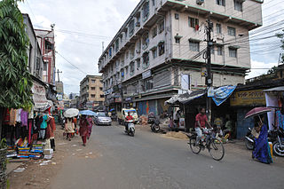
Narendrapur is a neighbourhood in the Rajpur Sonarpur of the South 24 Parganas district in the Indian state of West Bengal. It is a part of the area covered by the Kolkata Metropolitan Development Authority (KMDA).

Khardaha is a city and a municipality of North 24 Parganas district in the Indian state of West Bengal. It is near Kolkata and also a part of the area covered by Kolkata Metropolitan Development Authority (KMDA).

Sodepur or Sodpur is a locality in Panihati Municipality of North 24 Parganas district in the Indian state of West Bengal. It is close to Kolkata and also a part of the area covered by Kolkata Metropolitan Development Authority (KMDA).

North 24 Parganas or sometimes North Twenty Four Parganas is a district in southern West Bengal, of eastern India. North 24 Parganas extends in the tropical zone from latitude 22° 11′ 6″ north to 23° 15′ 2″ north and from longitude 88º20' east to 89º5' east. Barasat is the district headquarters of North 24 Parganas. North 24 Parganas is West Bengal's most populous district and also the most populated district in the whole of India. It is the tenth-largest district in the State by area.

Baranagar or Baranagore is a city and a municipality of North 24 Parganas district in the Indian state of West Bengal. It is close to Kolkata and also a part of the area covered by Kolkata Metropolitan Development Authority (KMDA). Baranagar is the fifth most densely populated city proper in the world.
Duttapukur is a census town in the Barasat I CD block in the Barasat Sadar subdivision in the North 24 Parganas district in the Indian state of West Bengal. It is a part of Kolkata Urban Agglomeration.
Patulia is a census town in Barrackpore II CD Block in Barrackpore subdivision in North 24 Parganas district in the Indian state of West Bengal. It is close to Kolkata and also a part of Kolkata Urban Agglomeration.

South Dum Dum is a city and a municipality of North 24 Parganas district in the Indian state of West Bengal. It is close to Kolkata and also a part of the area covered by Kolkata Metropolitan Development Authority (KMDA).

Belgharia is a locality in Kamarhati Municipality of North 24 Parganas district in the Indian state of West Bengal. It is close to Kolkata and also a part of the area covered by Kolkata Metropolitan Development Authority (KMDA). Belgharia is also known for wholesale market for all types of Bags/Luggages/Purse etc. One must visit and check the Bag Market beside Belgharia Railway Station. Dakshineswar Kali Temple of Kolkata is in approximately three kilometers distance from Belgharia Railway Station. The Vivekananda Setu on the river of Hooghly which is one of the oldest bridge in Calcutta established for the connection between the city of Howrah and Kolkata is also at the adjacent area of Belgharia.
Chandpur is a census town in Barrackpore II CD Block in Barrackpore subdivision in North 24 Parganas district in the state of West Bengal, India. It is close to Kolkata and also a part of Kolkata Urban Agglomeration.

Entally is a neighbourhood of Central Kolkata, in Kolkata district in the Indian state of West Bengal. It was considered close to the area which was home to the poor and the depressed castes. Mother Teresa started her activities in Entally.

Ramakrishna Mission Vivekananda Centenary College, popularly known as Rahara V.C college is one of the best colleges of West Bengal, currently Autonomous and affiliated to the West Bengal State University. It is named after Swami Vivekananda. It was formerly affiliated with the Calcutta University. It is administered by the Ramakrishna Mission Order. The College is situated in Rahara, Khardaha, North 24 Parganas district in the state of West Bengal, India. The college was ranked 15th among other colleges in India by the National Institutional Ranking Framework (NIRF) in 2021.
Barrrackpore subdivision is an administrative subdivision of the North 24 Parganas district in the Indian state of West Bengal.
Ghola is a locality in Panihati Municipality of North 24 Parganas district in the Indian state of West Bengal. It is close to Kolkata and also a part of the area covered by Kolkata Metropolitan Development Authority (KMDA).

Noapara is a locality in Baranagar of North 24 Parganas district in the Indian state of West Bengal. It is close to Kolkata and also a part of the area covered by Kolkata Metropolitan Development Authority (KMDA).
Agarpara is a locality in Panihati Municipality of North 24 Parganas district in the Indian state of West Bengal. It is close to Kolkata and also a part of the area covered by Kolkata Metropolitan Development Authority (KMDA).Agarpara has two pincode area -(a)700058,(b)700109
Bandipur is a census town in Barrackpore II CD Block in Barrackpore subdivision of North 24 Parganas district in the state of West Bengal, India. It is close to Kolkata and also a part of Kolkata Urban Agglomeration.

Khardaha railway station is the railway station in the town of Khardaha. It serves the local areas of Khardaha and as well as Rahara in North 24 Parganas district, West Bengal, India. This railway station is well connected towards south with Sealdah, which is one of India's major railway terminal serving the city of Kolkata. Towards north, it is well connected with some Big Railway Junctions like Barrackpore, Naihati, Bandel and Barddhaman. This station is a part of Kolkata suburban rail system and is under jurisdiction of Eastern Railway zone of Indian Railways. Khardaha Railway Station comes under Seladah-Ranaghat Main line. Only EMU train service is available from here at present.


