
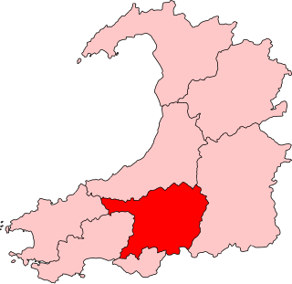
Ceredigion is a principal area of Wales, corresponding to the historic county of Cardiganshire. During the second half of the first millennium Ceredigion was a minor kingdom. It has been administered as a county since 1282. Ceredigion is considered a centre of Welsh culture and more than half the population can speak Welsh. The county is mainly rural with over 50 miles (80 km) of coastline and a mountainous hinterland. The numerous sandy beaches and the long-distance Ceredigion Coast Path provide excellent views of Cardigan Bay.

Borth, is a village and seaside resort in Ceredigion, Mid Wales, 7 miles (11 km) north of Aberystwyth on the Ceredigion Coast Path. The population was 1,399 in 2011. From being largely Welsh-speaking, the village has become anglicised: over 54 per cent of its residents were born in England. The community includes the settlement of Ynyslas.
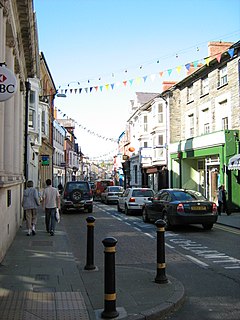
Cardigan is both a town and a community in the county of Ceredigion, Wales. The town lies on the tidal reach of the River Teifi at the point where Ceredigion meets Pembrokeshire. Cardigan was the county town of the historic county of Cardiganshire. Cardigan is the second-largest town in Ceredigion. The largest town, Aberystwyth, is one of the two administrative centres; the other is Aberaeron.

Newcastle Emlyn is a town on the River Teifi, straddling the counties of Ceredigion and Carmarthenshire in West Wales. It is also a community entirely within Carmarthenshire, bordered by those of Llangeler and Cenarth, also in Carmarthenshire, and by Llandyfriog in Ceredigion. Adpar is the part of town on the Ceredigion side of the River Teifi. It was formerly called Trefhedyn and was an ancient Welsh borough in its own right. The area including Adpar had a population of 1,883 according to the 2011 census.

Lampeter is a town, community and electoral ward in Ceredigion, Wales, at the confluence of the Afon Dulas with the River Teifi. It is the third largest urban area in Ceredigion, after Aberystwyth and Cardigan, and has a campus of the University of Wales Trinity Saint David. At the 2011 Census, the population was 2,970. Lampeter is the smallest university town in the United Kingdom. The university adds approximately 1,000 people to the town's population during term time.

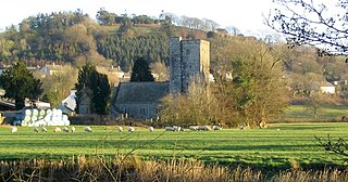
Cenarth is a village, parish and community in Carmarthenshire, on the border between Ceredigion and Carmarthenshire, and close to the border with Pembrokeshire, Wales. It stands on the banks of the River Teifi, 6 miles (9.7 km) east of Cardigan and 4 miles (6.4 km) west of Newcastle Emlyn, and features the Cenarth Falls, a popular visitor attraction, and several other listed structures including an 18th-century corn mill incorporating the National Coracle Centre.

Aberporth is a Welsh coastal village, local-government community and electoral ward in Ceredigion. The population at the 2001 Census, was 2,485, of whom 49 per cent could speak the Welsh language. At the 2011 Census, the population of the community was 2,374 and of the village 1241. Aberporth's beaches have earned Blue Flag status.
Llanybydder is a market town and community straddling the River Teifi in Carmarthenshire, West Wales. At the 2011 Census, the population of the community was 1,638, an increase from 1,423 at the 2001 Census.
Penparcau is both a village and an electoral ward in Ceredigion, Wales, situated to the south of Aberystwyth. The village has the largest number of Welsh language speakers (1095) in the Aberystwyth town area, covering an area from the sea to the Rheidol.
Carmarthen East and Dinefwr is a constituency of the Senedd. It elects one Member of the Senedd by the first past the post method of election. Also, however, it is one of eight constituencies in the Mid and West Wales electoral region, which elects four additional members, in addition to eight constituency members, to produce a degree of proportional representation for the region as a whole.

Llangeler is a hamlet and community located in north Carmarthenshire, Wales. The name is believed to refer to St. Gelert. Llangeler parish covers a wide area including to the west, the textile village of Drefach Felindre, Waungilwen, Cwmpengraig and to the east, Pont Tyweli which adjoins Llandysul on the Carmarthenshire side of the River Teifi. The population of the parish was 3,222 at the Census of 2001, increasing to 3,427 at the 2011 census.

Cyfarthfa is a community and electoral ward in the west of the town of Merthyr Tydfil in Merthyr Tydfil County Borough, Wales.
Cenarth is an electoral ward, representing the communities of Newcastle Emlyn and Cenarth, Carmarthenshire, Wales. It is named Cenarth, rather than Newcastle Emlyn because the rural community of Cenarth has a larger population than the urban settlement of Newcastle Emlyn. A similar ward for local elections prior to 1987 was named Newcastle Emlyn.
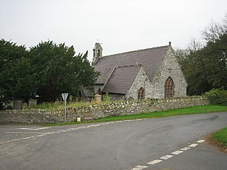
Troedyraur is a small village, wider rural community and electoral ward in Ceredigion, Wales. The community consisting of several small villages, the population as of the 2011 UK Census was 1,310.

Milford Hakin is the name of an electoral ward in Pembrokeshire, Wales. It covers the Hakin area of the Milford Haven community, to the west of Milford Haven Docks. It elects a councillor to Pembrokeshire County Council and three councillors to Milford Haven Town Council.

Pembroke Dock Llanion is the name of an electoral ward in the town of Pembroke Dock, Pembrokeshire, Wales.
Llanwrtyd Wells is the name of an electoral ward in mid Powys, Wales. It covers three local government communities and elects a councillor to Powys County Council.

Aberystwyth Rheidol is the name of a local government electoral ward in the town of Aberystwyth, Ceredigion, Wales. It elects a county councillor to Ceredigion County Council and also elects town councillors to Aberystwyth Town Council.
Pembroke St Michael is the name of an electoral ward in the town of Pembroke, Pembrokeshire, Wales. It covers the east area of the town.

Narberth is the name of an electoral ward in Pembrokeshire, Wales. Since 1995 it has elected one councillor to Pembrokeshire County Council.

